Montgomery County, Georgia facts for kids
Quick facts for kids
Montgomery County
|
|
|---|---|

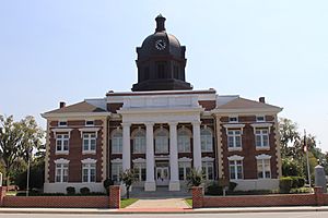
Montgomery County Courthouse (built 1907) in Mount Vernon
|
|

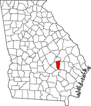
Location within the U.S. state of Georgia
|
|
 Georgia's location within the U.S. |
|
| Country | |
| State | |
| Founded | December 19, 1793 |
| Named for | Richard Montgomery |
| Seat | Mount Vernon |
| Largest city | Mount Vernon |
| Area | |
| • Total | 245 sq mi (630 km2) |
| • Land | 240 sq mi (600 km2) |
| • Water | 5.2 sq mi (13 km2) 2.1%% |
| Population
(2020)
|
|
| • Total | 8,610 |
| • Density | 36/sq mi (14/km2) |
| Time zone | UTC−5 (Eastern) |
| • Summer (DST) | UTC−4 (EDT) |
| Congressional district | 12th |
Montgomery County is a county in the central part of Georgia, USA. In 2020, about 8,610 people lived here. The main town and government center is Mount Vernon. Montgomery County is also part of the larger Vidalia area.
Contents
History of Montgomery County
Montgomery County is named after Richard Montgomery. He was an important general in the American Revolutionary War. He died in 1775 while trying to capture Quebec City, Canada. The county was officially created on December 19, 1793. It was formed from a southern part of Washington County, Georgia.
The first county seat, which is like the main town for the county's government, was Arthur Lott's Plantation in 1797.
In 1801, a new county called Tattnall County, Georgia was made from the southern part of Montgomery County. This changed Montgomery County's borders.
Changes to County Borders
Over the years, the borders of Montgomery County changed several times. On December 11, 1811, some land was moved between Washington, Montgomery, and Laurens counties. The next year, on December 10, 1812, Emanuel County was created. This caused a big change to Montgomery County's shape.
Because of these changes, the old county seat ended up inside Emanuel County. So, in 1812, a group of local leaders was chosen to find a new county seat. In 1813, Mount Vernon was chosen as the new main town for the county.
More border changes happened in 1820 and 1833, mostly with Telfair County. These changes helped to clearly define where Montgomery County ended and other counties began.
During the American Civil War
Before the American Civil War, in 1850, Montgomery County had more white residents than enslaved people. By 1860, there were 2,014 white people and 977 enslaved people. The land here wasn't ideal for large cotton farms that used many enslaved workers. This difference in farming and population meant that Montgomery County had different ideas about leaving the Union compared to other parts of Georgia.
On January 22, 1861, two representatives from Montgomery County, Thomas M. McRae and Solon Homer Latimer, voted against Georgia leaving the United States. They were among the few who disagreed with the decision to secede.
New Counties Formed
Over time, parts of Montgomery County were used to create other new counties.
- On August 18, 1905, Toombs County was formed.
- On August 14, 1912, Wheeler County was created from parts of Montgomery County.
- On August 21, 1917, Treutlen County was also formed using some of Montgomery County's land.
Recent History
For many years, Montgomery County schools held separate proms for different groups of students, even after schools were integrated in the 1970s. However, in 2010, students in Montgomery County decided to change this. They took the lead and organized the first integrated prom, bringing everyone together.
Geography
Montgomery County covers about 245 square miles. Most of this area, about 240 square miles, is land. The remaining 5.2 square miles is water.
The county is located within the larger Altamaha River basin. This means that the rivers and streams in Montgomery County eventually flow into the Altamaha River. Different parts of the county are in smaller river areas, like the Lower Oconee River and the Ohoopee River sub-basins.
Major Highways
Neighboring Counties
Montgomery County shares borders with these counties:
- Treutlen County (to the north)
- Toombs County (to the east)
- Jeff Davis County (to the south)
- Wheeler County (to the west)
Communities
Montgomery County has several towns and cities.
Cities
- Ailey
- Mount Vernon (This is the county seat)
- Uvalda
Towns
Unincorporated Community
- Charlotteville
Population Data
| Historical population | |||
|---|---|---|---|
| Census | Pop. | %± | |
| 1800 | 3,180 | — | |
| 1810 | 2,954 | −7.1% | |
| 1820 | 1,869 | −36.7% | |
| 1830 | 1,269 | −32.1% | |
| 1840 | 1,616 | 27.3% | |
| 1850 | 2,154 | 33.3% | |
| 1860 | 2,997 | 39.1% | |
| 1870 | 3,586 | 19.7% | |
| 1880 | 5,381 | 50.1% | |
| 1890 | 9,248 | 71.9% | |
| 1900 | 16,359 | 76.9% | |
| 1910 | 19,638 | 20.0% | |
| 1920 | 9,167 | −53.3% | |
| 1930 | 10,020 | 9.3% | |
| 1940 | 9,668 | −3.5% | |
| 1950 | 7,901 | −18.3% | |
| 1960 | 6,284 | −20.5% | |
| 1970 | 6,099 | −2.9% | |
| 1980 | 7,011 | 15.0% | |
| 1990 | 7,163 | 2.2% | |
| 2000 | 8,270 | 15.5% | |
| 2010 | 9,123 | 10.3% | |
| 2020 | 8,610 | −5.6% | |
| 2023 (est.) | 8,761 | −4.0% | |
| U.S. Decennial Census 1790-1880 1890-1910 1920-1930 1930-1940 1940-1950 1960-1980 1980-2000 2010 |
|||
This table shows the different groups of people living in Montgomery County in 2020:
| Race | Number of People | Percentage |
|---|---|---|
| White (not Hispanic) | 5,665 | 65.8% |
| Black or African American (not Hispanic) | 2,120 | 24.62% |
| Native American | 11 | 0.13% |
| Asian | 34 | 0.39% |
| Other/Mixed | 209 | 2.43% |
| Hispanic or Latino | 571 | 6.63% |
As of the 2020 census, there were 8,610 people living in the county. These people made up 3,097 households and 2,102 families.
See also
 In Spanish: Condado de Montgomery (Georgia) para niños
 | Delilah Pierce |
 | Gordon Parks |
 | Augusta Savage |
 | Charles Ethan Porter |

