Uvalda, Georgia facts for kids
Quick facts for kids
Uvalda, Georgia
|
|
|---|---|

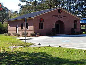
Uvalda City Hall
|
|

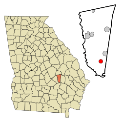
Location in Montgomery County and the state of Georgia
|
|
| Country | United States |
| State | Georgia |
| County | Montgomery |
| Area | |
| • Total | 1.91 sq mi (4.94 km2) |
| • Land | 1.89 sq mi (4.90 km2) |
| • Water | 0.01 sq mi (0.03 km2) |
| Elevation | 177 ft (54 m) |
| Population
(2020)
|
|
| • Total | 439 |
| • Density | 231.91/sq mi (89.56/km2) |
| Time zone | UTC-5 (Eastern (EST)) |
| • Summer (DST) | UTC-4 (EDT) |
| ZIP code |
30473
|
| Area code(s) | 912 |
| FIPS code | 13-78744 |
| GNIS feature ID | 0324646 |
Uvalda is a small city located in Montgomery County, Georgia, in the United States. In 2020, about 439 people lived there. This number was a bit lower than the 598 people who lived there in 2010.
Contents
History of Uvalda
The name "Uvalda" comes from Juan de Ugalde. He was an important person in the history of Texas. The government of Georgia, called the Georgia General Assembly, officially made Uvalda a town in 1910. This meant it could have its own local government.
Geography of Uvalda
Uvalda is located in the southern part of Montgomery County. It is found at coordinates 32°2′16″N 82°30′32″W. A main road, U.S. Route 221, goes right through the middle of the city. This road connects Uvalda to other towns.
If you go north-northwest on US 221, you will reach Mount Vernon. This town is about 11 miles away and is the main city for Montgomery County. If you go south-southwest for about 13 miles, you will get to Hazlehurst.
Another road, Georgia State Route 56, also follows US 221 for a bit. But it then turns east and goes about 25 miles to Reidsville. State Route 135 also passes through Uvalda. It goes south to Hazlehurst with US 221 and north-northeast about 13 miles to Higgston.
The city of Uvalda covers an area of about 1.9 square miles (4.9 square kilometers). Most of this area is land. Only a very small part, about 0.01 square miles (0.03 square kilometers), is water. Milligan Creek flows through the city, just east of its center. This creek eventually flows into the Altamaha River.
Population Changes in Uvalda
| Historical population | |||
|---|---|---|---|
| Census | Pop. | %± | |
| 1920 | 240 | — | |
| 1930 | 513 | 113.8% | |
| 1940 | 592 | 15.4% | |
| 1950 | 511 | −13.7% | |
| 1960 | 589 | 15.3% | |
| 1970 | 663 | 12.6% | |
| 1980 | 646 | −2.6% | |
| 1990 | 561 | −13.2% | |
| 2000 | 530 | −5.5% | |
| 2010 | 598 | 12.8% | |
| 2020 | 439 | −26.6% | |
| U.S. Decennial Census | |||
Every ten years, the United States counts its population. This count is called a census. In the year 2000, the census showed that 530 people lived in Uvalda. There were 201 households, which are like homes or families living together. Out of these, 147 were families. By the time of the 2020 census, the population of Uvalda had gone down to 439 people.
Famous People from Uvalda
- Wally Moses: He was a professional baseball player. He played as an outfielder in Major League Baseball.
See also
 In Spanish: Uvalda para niños
 | Sharif Bey |
 | Hale Woodruff |
 | Richmond Barthé |
 | Purvis Young |

