
Treutlen County, Georgia facts for kids
Quick facts for kids
Treutlen County
|
||
|---|---|---|

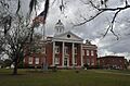
Treutlen County Courthouse in Soperton
|
||
|
||

Location within the U.S. state of Georgia
|
||
 Georgia's location within the U.S. |
||
| Country | ||
| State | ||
| Founded | November 5, 1918 | |
| Named for | John A. Treutlen | |
| Seat | Soperton | |
| Largest city | Soperton | |
| Area | ||
| • Total | 202 sq mi (520 km2) | |
| • Land | 199 sq mi (520 km2) | |
| • Water | 3.0 sq mi (8 km2) 1.5%% | |
| Population
(2020)
|
||
| • Total | 6,406 | |
| • Density | 32/sq mi (12/km2) | |
| Time zone | UTC−5 (Eastern) | |
| • Summer (DST) | UTC−4 (EDT) | |
| Congressional district | 12th | |

Treutlen County is a county located in the east central part of Georgia, a state in the United States. As of the 2020 census, about 6,406 people live here. The main town and county seat is Soperton. Treutlen County is famous for its Million Pines Arts and Crafts Festival. This fun event happens every year during the first weekend of November.
Contents
Discover Treutlen County's Past
Before European settlers arrived, the land that is now Treutlen County was home to the Muscogee people. After the American Revolution, settlers were drawn to the area. They liked the "wiregrass" (a type of tough grass) and the large forests of longleaf pine trees.
Early Industries and Growth
The tall pine forests helped a timber industry grow. People worked in jobs like cabinetmaking, milling wood, and making turpentine. Turpentine and other "naval stores" (products from pine trees) were important for building and maintaining ships.
It was hard to build roads in this area because of the landscape. This meant not many people lived here until after the Civil War. That's when railroads started to arrive. In 1902, the Macon, Dublin and Savannah Railroad built a new line. It connected Macon to Vidalia and included a train station near Lothair. The new town of Soperton quickly grew bigger than Lothair because of this new rail link.
How Treutlen County Was Formed
The idea to create Treutlen County was led by Neil L. Gillis. He is known as the "father of Treutlen County" because he worked so hard to make it happen. The state government of Georgia officially suggested creating the county on August 21, 1917. It was approved on November 5, 1918. This made Treutlen County the 154th county in Georgia.
The county was formed from parts of Emanuel and Montgomery counties. It was named after John A. Treutlen, who was Georgia's first governor after the state's first constitution was written in 1777. Since Soperton had grown so much, it was the clear choice to become the county seat.
Pine Trees and Paper Production
In the 1920s, a local cotton farmer named James Fowler planted over 7 million pine trees. These trees covered about 10,000 acres of land. Fowler worked with a scientist named Charles Herty. Herty found a way to use pine pulp (the soft material from inside pine trees) to make paper. This was a big step for the paper industry.
Geography and Natural Features
Treutlen County covers about 202 square miles. About 199 square miles are land, and 3 square miles (which is 1.5%) are water. A large part of the county, about 90%, is covered by forests.
River Basins and Waterways
The western part of Treutlen County, which is west of Soperton, is in the Lower Oconee River sub-basin. This sub-basin is part of the larger Altamaha River basin. The eastern part of the county is in the Ohoopee River sub-basin, which is also part of the Altamaha River basin. These rivers and their branches are important waterways in the area.
Main Roads and Routes
Treutlen County has several important highways that connect it to other parts of Georgia.
 Interstate 16
 U.S. Route 221
 State Route 15
 State Route 29
 State Route 46
 State Route 56
 State Route 78
 State Route 86
 State Route 171
 State Route 199
 State Route 199 Spur
 State Route 227
 State Route 297
 State Route 298
 State Route 404 (This is another name for I-16)
Neighboring Counties
Treutlen County shares borders with several other counties:
- Emanuel County (to the northeast)
- Montgomery County (to the southeast)
- Wheeler County (to the southwest)
- Laurens County (to the west)
- Johnson County (to the northwest)
Communities in Treutlen County
Treutlen County has one main city and a couple of smaller communities.
City
- Soperton (This is the county seat, where the main government offices are located.)
Unincorporated Communities
These are smaller areas that are not officially cities or towns.
- Gillis Springs
- Lothair
Population and People
The population of Treutlen County has changed over the years. Here's a look at how many people have lived there during different census counts.
| Historical population | |||
|---|---|---|---|
| Census | Pop. | %± | |
| 1920 | 7,664 | — | |
| 1930 | 7,488 | −2.3% | |
| 1940 | 7,632 | 1.9% | |
| 1950 | 6,522 | −14.5% | |
| 1960 | 5,874 | −9.9% | |
| 1970 | 5,647 | −3.9% | |
| 1980 | 6,087 | 7.8% | |
| 1990 | 5,994 | −1.5% | |
| 2000 | 6,854 | 14.3% | |
| 2010 | 6,885 | 0.5% | |
| 2020 | 6,406 | −7.0% | |
| 2023 (est.) | 6,341 | −7.9% | |
| U.S. Decennial Census 1790-1880 1890-1910 1920-1930 1930-1940 1940-1950 1960-1980 1980-2000 2010 |
|||
Who Lives in Treutlen County?
The table below shows the different groups of people living in Treutlen County as of 2020. This information comes from the U.S. Census.
| Race | Num. | Perc. |
|---|---|---|
| White (non-Hispanic) | 4,065 | 63.46% |
| Black or African American (non-Hispanic) | 1,999 | 31.21% |
| Native American | 19 | 0.3% |
| Asian | 7 | 0.11% |
| Other/Mixed | 146 | 2.28% |
| Hispanic or Latino | 170 | 2.65% |
In 2020, there were 6,406 people living in the county. These people lived in 2,490 households, and 1,654 of those households were families.
Images for kids
-
Treutlen County Courthouse in Soperton
See also
 In Spanish: Condado de Treutlen para niños
