Johnson County, Georgia facts for kids
Quick facts for kids
Johnson County
|
|
|---|---|

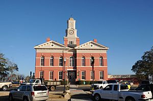
Johnson County Courthouse in Wrightsville
|
|

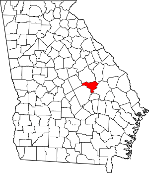
Location within the U.S. state of Georgia
|
|
 Georgia's location within the U.S. |
|
| Country | |
| State | |
| Founded | December 11, 1858 |
| Named for | Herschel Vespasian Johnson |
| Seat | Wrightsville |
| Largest city | Wrightsville |
| Area | |
| • Total | 307 sq mi (800 km2) |
| • Land | 303 sq mi (780 km2) |
| • Water | 3.6 sq mi (9 km2) 1.2%% |
| Population
(2020)
|
|
| • Total | 9,189 |
| • Estimate
(2023)
|
9,282 |
| • Density | 29.93/sq mi (11.557/km2) |
| Time zone | UTC−5 (Eastern) |
| • Summer (DST) | UTC−4 (EDT) |
| Congressional district | 12th |
Johnson County is a county located in the state of Georgia, along the Oconee River. In 2020, about 9,189 people lived here. The main town and county seat is Wrightsville. Johnson County is also part of the Dublin area.
Contents
History of Johnson County
Johnson County was created on December 11, 1858. It was formed from parts of three other counties: Emanuel, Laurens, and Washington. The county was named after Herschel Vespasian Johnson. He was a very important person in Georgia. He served as the state's governor and also as a senator. He even ran for U.S. vice-president once!
Exploring Johnson County's Geography
Johnson County covers a total area of about 307 square miles. Most of this area, around 303 square miles, is land. The remaining 3.6 square miles, which is about 1.2%, is water.
Most of the county is located within the Ohoopee River sub-basin. This sub-basin is part of the larger Altamaha River basin. Small parts of the county's northeastern side are in the Ogeechee River basin. The western corner of Johnson County is in the Lower Oconee River sub-basin, which is also part of the Altamaha River basin.
Main Roads in Johnson County
Many important roads pass through Johnson County. These highways help people travel around the county and to other parts of Georgia.
Neighboring Counties
Johnson County shares its borders with several other counties in Georgia.
- Washington County - to the north
- Jefferson County - to the northeast
- Emanuel County - to the east
- Treutlen County - to the south
- Laurens County - to the southwest
- Wilkinson County - to the west
Towns and Communities
Johnson County has a few towns where people live and work.
Population Changes Over Time
| Historical population | |||
|---|---|---|---|
| Census | Pop. | %± | |
| 1860 | 2,919 | — | |
| 1870 | 2,964 | 1.5% | |
| 1880 | 4,800 | 61.9% | |
| 1890 | 6,129 | 27.7% | |
| 1900 | 11,409 | 86.1% | |
| 1910 | 12,897 | 13.0% | |
| 1920 | 13,546 | 5.0% | |
| 1930 | 12,681 | −6.4% | |
| 1940 | 12,953 | 2.1% | |
| 1950 | 9,893 | −23.6% | |
| 1960 | 8,048 | −18.6% | |
| 1970 | 7,727 | −4.0% | |
| 1980 | 8,660 | 12.1% | |
| 1990 | 8,329 | −3.8% | |
| 2000 | 8,560 | 2.8% | |
| 2010 | 9,980 | 16.6% | |
| 2020 | 9,189 | −7.9% | |
| 2023 (est.) | 9,282 | −7.0% | |
| U.S. Decennial Census 1790-1880 1890-1910 1920-1930 1930-1940 1940-1950 1960-1980 1980-2000 2010 2020 |
|||
Who Lives in Johnson County?
The 2020 United States census counted 9,189 people living in Johnson County. These people lived in 3,393 households, with 2,208 of those being families.
Here's a look at the different groups of people who live in Johnson County:
| Race | Number of People | Percentage |
|---|---|---|
| White (not Hispanic) | 5,800 | 63.12% |
| Black or African American (not Hispanic) | 3,017 | 32.83% |
| Native American | 23 | 0.25% |
| Asian | 28 | 0.3% |
| Pacific Islander | 15 | 0.16% |
| Other/Mixed | 189 | 2.06% |
| Hispanic or Latino | 117 | 1.27% |
Education in Johnson County
The public schools in Johnson County are located in Wrightsville. In 1970, the schools in Johnson County became integrated peacefully. This happened because the county's board of education planned carefully. The superintendent, Buren Claxton, also managed the process very well.
The school mascot for Johnson County schools is the Trojan. The school colors are blue and white. The school's fight song is the theme music from the movie Hang 'Em High.
Sports and Local Heroes
Johnson County has a strong connection to sports history. Herschel Walker, a famous athlete, grew up in Johnson County. He was part of the county's only state championship football team in 1979.
After high school, Walker went on to play football for the University of Georgia. He even won the Heisman Trophy, which is a huge award for college football players. In 2004, Johnson County High School honored him by naming its football field after him.
See also
 In Spanish: Condado de Johnson (Georgia) para niños
 | Madam C. J. Walker |
 | Janet Emerson Bashen |
 | Annie Turnbo Malone |
 | Maggie L. Walker |

