Wilkinson County, Georgia facts for kids
Quick facts for kids
Wilkinson County
|
|
|---|---|

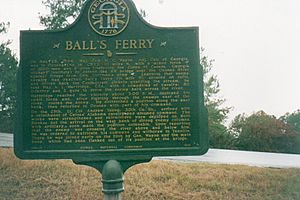
Ball's Ferry Landing has been designated as a site on the March to the Sea Heritage Trail.
|
|

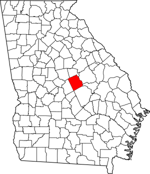
Location within the U.S. state of Georgia
|
|
 Georgia's location within the U.S. |
|
| Country | |
| State | |
| Founded | May 11, 1803 |
| Named for | James Wilkinson |
| Seat | Irwinton |
| Largest city | Gordon |
| Area | |
| • Total | 452 sq mi (1,170 km2) |
| • Land | 447 sq mi (1,160 km2) |
| • Water | 4.6 sq mi (12 km2) 1.0% |
| Population
(2020)
|
|
| • Total | 8,877 |
| Time zone | UTC−5 (Eastern) |
| • Summer (DST) | UTC−4 (EDT) |
| Congressional district | 8th |
Wilkinson County is a place in the middle part of Georgia. It is a county in the United States. In 2020, about 8,877 people lived here. The main town, or county seat, is Irwinton. Wilkinson County was started on May 11, 1803. It was named after a famous person named General James Wilkinson.
Contents
About the Land and Rivers
Wilkinson County covers about 452 square miles. Most of this area, about 447 square miles, is land. The rest, about 4.6 square miles, is water. That's about 1% water!
The county is mostly in a flat area called the Atlantic coastal plain. But it also has some rolling hills. This is because it's close to a special line called the fall line.
All of Wilkinson County is part of the Oconee River area. This river flows into the larger Altamaha River.
Main Roads in Wilkinson County
Many important roads go through Wilkinson County. These roads help people travel and connect different towns.
Neighboring Counties
Wilkinson County shares its borders with several other counties. These are:
- Baldwin County (to the north)
- Bleckley County (to the south)
- Washington County (to the northeast)
- Johnson County (to the east)
- Laurens County (to the southeast)
- Twiggs County (to the southwest)
- Jones County (to the northwest)
Towns and Villages
Wilkinson County has several towns and a few smaller communities.
Cities in Wilkinson County
Smaller Communities
These places are not officially cities but are still communities where people live:
- Nicklesville
- Stephensville
Population Information
| Historical population | |||
|---|---|---|---|
| Census | Pop. | %± | |
| 1810 | 2,154 | — | |
| 1820 | 6,992 | 224.6% | |
| 1830 | 6,513 | −6.9% | |
| 1840 | 6,842 | 5.1% | |
| 1850 | 8,296 | 21.3% | |
| 1860 | 9,376 | 13.0% | |
| 1870 | 9,383 | 0.1% | |
| 1880 | 12,061 | 28.5% | |
| 1890 | 10,871 | −9.9% | |
| 1900 | 11,440 | 5.2% | |
| 1910 | 10,078 | −11.9% | |
| 1920 | 11,376 | 12.9% | |
| 1930 | 10,844 | −4.7% | |
| 1940 | 11,025 | 1.7% | |
| 1950 | 9,781 | −11.3% | |
| 1960 | 9,250 | −5.4% | |
| 1970 | 9,393 | 1.5% | |
| 1980 | 10,368 | 10.4% | |
| 1990 | 10,228 | −1.4% | |
| 2000 | 10,220 | −0.1% | |
| 2010 | 9,563 | −6.4% | |
| 2020 | 8,877 | −7.2% | |
| 2023 (est.) | 8,725 | −8.8% | |
| U.S. Decennial Census 1790-1880 1890-1910 1920-1930 1930-1940 1940-1950 1960-1980 1980-2000 2010 2020 |
|||
In 2020, the census counted 8,877 people living in Wilkinson County. There were 3,185 households and 2,079 families.
| Race | Number of People | Percentage |
|---|---|---|
| White (not Hispanic) | 5,110 | 57.56% |
| Black or African American (not Hispanic) | 3,163 | 35.63% |
| Native American | 30 | 0.34% |
| Asian | 22 | 0.25% |
| Pacific Islander | 3 | 0.03% |
| Other/Mixed | 310 | 3.49% |
| Hispanic or Latino | 239 | 2.69% |
Schools in the County
The only school system in Wilkinson County is the Wilkinson County School District. This district manages all the public schools in the area.
See also
 In Spanish: Condado de Wilkinson (Georgia) para niños
 | Aaron Henry |
 | T. R. M. Howard |
 | Jesse Jackson |

