Jeffersonville, Georgia facts for kids
Quick facts for kids
Jeffersonville, Georgia
|
|
|---|---|

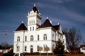
Twiggs County Courthouse (built 1903), Jeffersonville, Georgia
|
|

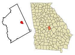
Location in Twiggs County and the state of Georgia
|
|
| Country | United States |
| State | Georgia |
| County | Twiggs |
| Area | |
| • Total | 3.67 sq mi (9.50 km2) |
| • Land | 3.65 sq mi (9.47 km2) |
| • Water | 0.01 sq mi (0.03 km2) |
| Elevation | 518 ft (158 m) |
| Population
(2020)
|
|
| • Total | 977 |
| • Density | 267.31/sq mi (103.20/km2) |
| Time zone | UTC-5 (Eastern (EST)) |
| • Summer (DST) | UTC-4 (EDT) |
| ZIP code |
31044
|
| Area code(s) | 478 |
| FIPS code | 13-42100 |
| GNIS feature ID | 0356333 |
Jeffersonville is a city in Georgia, United States. It is the biggest city and the main town (called the county seat) in Twiggs County. In 2010, about 1,035 people lived here. Jeffersonville is also part of the larger Macon area.
Contents
A Look Back: Jeffersonville's History
Jeffersonville got its name from the Jefferson family. They were some of the first people to settle there. In 1868, Jeffersonville became the main town for Twiggs County. Before that, another town called Marion was the county seat.
Where is Jeffersonville?
Jeffersonville is located in the central part of Georgia. It is very close to the exact middle of the state. You can find it at coordinates 32.683982 degrees North and -83.339683 degrees West.
Getting Around Jeffersonville
Interstate 16 runs just south of the city. This highway can take you 148 miles (238 km) southeast to Savannah. It also goes 25 miles (40 km) northwest to Macon. U.S. Route 80 also passes through Jeffersonville. Other important roads include State Route 18 and State Route 96.
How Big is the City?
The United States Census Bureau says that Jeffersonville covers about 3.7 square miles (9.5 square kilometers). All of this area is land.
Who Lives in Jeffersonville?
| Historical population | |||
|---|---|---|---|
| Census | Pop. | %± | |
| 1880 | 156 | — | |
| 1910 | 740 | — | |
| 1920 | 842 | 13.8% | |
| 1930 | 692 | −17.8% | |
| 1940 | 804 | 16.2% | |
| 1950 | 787 | −2.1% | |
| 1960 | 1,013 | 28.7% | |
| 1970 | 1,302 | 28.5% | |
| 1980 | 1,473 | 13.1% | |
| 1990 | 1,545 | 4.9% | |
| 2000 | 1,209 | −21.7% | |
| 2010 | 1,035 | −14.4% | |
| 2020 | 977 | −5.6% | |
| U.S. Decennial Census 1850-1870 1870-1880 1890-1910 1920-1930 1940 1950 1960 1970 1980 1990 2000 2010 |
|||
In 2020, the census counted 977 people living in Jeffersonville. There were 375 households and 199 families.
Most people in Jeffersonville are Black or African American, making up about 64.69% of the population. White people make up about 31.42%. There are also smaller groups of Asian people and people of mixed races. About 1.43% of the population is Hispanic or Latino.
Learning in Jeffersonville
Jeffersonville has schools for students from pre-school all the way to twelfth grade.
Twiggs County School District
The Twiggs County School District is in charge of public schools in the area. It has two elementary schools (some with pre-school programs), one middle school, and one high school. The district employs 100 full-time teachers. Over 1,489 students attend these schools.
- Jeffersonville Elementary
- Twiggs Middle School
- Twiggs County High School
Private Education
- Twiggs Academy is a private school option in the area.
See also
 In Spanish: Jeffersonville (Georgia) para niños
 | Roy Wilkins |
 | John Lewis |
 | Linda Carol Brown |

