Allentown, Georgia facts for kids
Quick facts for kids
Allentown, Georgia
|
|
|---|---|

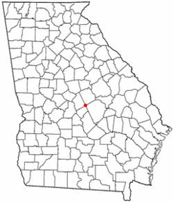
Location of Allentown, Georgia
|
|
| Country | United States |
| State | Georgia |
| Counties | Wilkinson, Twiggs, Laurens, Bleckley |
| Area | |
| • Total | 4.60 sq mi (11.92 km2) |
| • Land | 4.58 sq mi (11.86 km2) |
| • Water | 0.03 sq mi (0.07 km2) |
| Elevation | 430 ft (130 m) |
| Population
(2020)
|
|
| • Total | 195 |
| • Density | 42.60/sq mi (16.45/km2) |
| Time zone | UTC-5 (Eastern (EST)) |
| • Summer (DST) | UTC-4 (EDT) |
| ZIP code |
31003
|
| Area code(s) | 478 |
| FIPS code | 13-01500 |
| GNIS feature ID | 0310468 |
Allentown is a small city in the U.S. state of Georgia. It is unique because it is located across four different counties! These are Bleckley, Laurens, Twiggs, and Wilkinson counties. Most of Allentown is in Wilkinson County.
In 2010, about 169 people lived in Allentown. By 2020, the population grew a little to 195 people. Parts of Allentown are near bigger cities. The part in Twiggs County is close to the Macon area. The Laurens County part is near Dublin. The other parts are not near any large city areas.
Contents
History of Allentown
Allentown got its name in 1891. This was when a railroad, called the Macon, Dublin & Savannah Railroad, reached this spot. The town was named after John Allen, who was an early postmaster there. Allentown officially became a city in 1901.
Allentown's Location and Roads
The main part of Allentown, including most of its buildings, is in the southern corner of Wilkinson County. However, the city limits stretch out into Twiggs, Bleckley, and Laurens counties.
Several important roads pass through Allentown:
- U.S. Route 80 goes right through the middle of town. It can take you about 10 miles northwest to Jeffersonville. If you go southeast, it's about 20 miles to Dublin.
- Interstate 16 runs through the southern part of the city. You can get on or off at Exit 32, which is State Route 112. I-16 leads about 31 miles northwest to Macon. If you head southeast, it's about 134 miles to Savannah.
- Georgia State Route 112 is also known as Balls Ferry Road in Allentown. It goes northeast about 10 miles to U.S. Route 441 at Nicklesville. Going southwest, it's about 18 miles to Cochran.
Allentown covers a total area of about 4.6 square miles (11.9 square kilometers). A very small part of this area, about 0.03 square miles (0.07 square kilometers), is water.
The northern side of Allentown has water that flows into Devils Branch. This branch then joins Turkey Creek, which is part of the Oconee River system. The southern side of Allentown drains into Little Rocky Creek. This creek also flows into Rocky Creek, then Turkey Creek, and finally into the Oconee River.
Allentown's Population
| Historical population | |||
|---|---|---|---|
| Census | Pop. | %± | |
| 1960 | 450 | — | |
| 1970 | 295 | −34.4% | |
| 1980 | 321 | 8.8% | |
| 1990 | 273 | −15.0% | |
| 2000 | 287 | 5.1% | |
| 2010 | 169 | −41.1% | |
| 2020 | 195 | 15.4% | |
| U.S. Decennial Census | |||
In the year 2000, there were 287 people living in Allentown. There were 121 households and 72 families. By 2020, the population had changed to 195 people.
In 2023, most of Allentown's residents lived in Wilkinson County (110 people) or Twiggs County (59 people). At that time, no one lived in the small parts of Allentown that are in Bleckley and Laurens counties.
Schools in Allentown
The schools in Allentown depend on which county a student lives in:
- If you live in the Wilkinson County part of Allentown, you would attend schools in the Wilkinson County School District.
- If you live in the Twiggs County part, you would go to schools in the Twiggs County School District.
- The Bleckley County part is in the Bleckley County School District.
- The Laurens County part is in the Laurens County School District.
As of 2023, there were no students living in the Bleckley and Laurens county sections of Allentown.
 | Janet Taylor Pickett |
 | Synthia Saint James |
 | Howardena Pindell |
 | Faith Ringgold |

