Adrian, Georgia facts for kids
Quick facts for kids
Adrian, Georgia
|
|
|---|---|

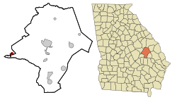
Location in Emanuel County, Georgia
|
|
| Country | United States |
| State | Georgia |
| Counties | |
| Area | |
| • Total | 1.42 sq mi (3.68 km2) |
| • Land | 1.38 sq mi (3.56 km2) |
| • Water | 0.04 sq mi (0.11 km2) |
| Elevation | 286 ft (87 m) |
| Population
(2020)
|
|
| • Total | 552 |
| • Density | 401.45/sq mi (155.02/km2) |
| Time zone | UTC-5 (Eastern (EST)) |
| • Summer (DST) | UTC-4 (EDT) |
| ZIP code |
31002
|
| Area code(s) | 478 |
| FIPS code | 13-00660 |
| GNIS feature ID | 0310411 |
Adrian is a small city located in the state of Georgia, USA. It is split between two counties: Emanuel County and Johnson County. In 2020, about 552 people lived in Adrian.
History of Adrian
A post office opened in Adrian in 1891, which means people were living and sending mail from here even back then. Adrian officially became a city in 1899. It's a bit of a mystery how the city got its name "Adrian."
Geography of Adrian
Adrian is located at 32°31′55″N 82°35′26″W / 32.53194°N 82.59056°W. This means it's in a specific spot on the map! It sits where several important roads meet. These roads include U.S. Route 80 and Georgia State Route 26, along with State Route 15 and State Route 78.
- U.S. Route 80 goes east about 16 miles (26 km) to Swainsboro. It goes west about 19 miles (31 km) to Dublin.
- State Routes 15 and 78 go south about 7 miles (11 km) to Interstate 16 near Soperton. They go northwest about 17 miles (27 km) to Wrightsville.
The United States Census Bureau says that Adrian covers a total area of about 1.42 square miles (3.7 square kilometers). Most of this area, about 1.38 square miles (3.6 square kilometers), is land. A small part, about 0.04 square miles (0.1 square kilometers), is water.
Population Information
| Historical population | |||
|---|---|---|---|
| Census | Pop. | %± | |
| 1900 | 833 | — | |
| 1910 | 816 | −2.0% | |
| 1920 | 740 | −9.3% | |
| 1930 | 685 | −7.4% | |
| 1940 | 580 | −15.3% | |
| 1950 | 503 | −13.3% | |
| 1960 | 568 | 12.9% | |
| 1970 | 705 | 24.1% | |
| 1980 | 756 | 7.2% | |
| 1990 | 615 | −18.7% | |
| 2000 | 579 | −5.9% | |
| 2010 | 664 | 14.7% | |
| 2020 | 552 | −16.9% | |
| U.S. Decennial Census 1850-1870 1880 1890-1910 1920-1930 1930-1940 1940-1950 1960-19801980-2000 |
|||
The population of Adrian has changed over the years. In 2020, the city had a population of 552 people. This information comes from the official U.S. Census.
See Also
 In Spanish: Adrian (Georgia) para niños
 | William Lucy |
 | Charles Hayes |
 | Cleveland Robinson |

