Garfield, Georgia facts for kids
Quick facts for kids
Garfield, Georgia
|
|
|---|---|

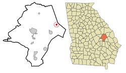
Location in Emanuel County and the state of Georgia
|
|
| Country | United States |
| State | Georgia |
| County | Emanuel |
| Area | |
| • Total | 0.80 sq mi (2.06 km2) |
| • Land | 0.79 sq mi (2.04 km2) |
| • Water | 0.01 sq mi (0.02 km2) |
| Elevation | 279 ft (85 m) |
| Population
(2020)
|
|
| • Total | 257 |
| • Density | 326.14/sq mi (125.88/km2) |
| Time zone | UTC-5 (Eastern (EST)) |
| • Summer (DST) | UTC-4 (EDT) |
| ZIP code |
30425
|
| Area code(s) | 478 |
| FIPS code | 13-32188 |
| GNIS feature ID | 0331791 |
Garfield is a small city located in Emanuel County, Georgia, in the United States. It's a quiet place where people live and work. In 2020, about 257 people called Garfield home.
Contents
History of Garfield
When Was Garfield Founded?
The area now known as Garfield officially became a town in 1905. This happened when the Georgia General Assembly, which is like the state's law-making body, decided to "incorporate" it. This means they gave Garfield the legal power to govern itself as a town.
Geography of Garfield
Where is Garfield Located?
Garfield is found in the eastern part of Emanuel County. You can find it by its coordinates: 32.650511 degrees North and -82.096319 degrees West.
Roads and Nearby Towns
Georgia State Route 23 is a main road that goes right through Garfield. If you travel northeast on this road for about 14 miles, you'll reach Millen. Going southwest for about 6 miles will take you to Twin City. The county seat, Swainsboro, is about 16 miles to the west.
Size of the City
According to the United States Census Bureau, Garfield covers a total area of about 2.1 square kilometers (or 0.80 square miles). Most of this area is land, with only a tiny part, about 0.02 square kilometers (or 0.01 square miles), being water.
Population of Garfield
How Many People Live in Garfield?
The number of people living in Garfield has changed over the years. Here's a look at the population counts from different census reports:
| Historical population | |||
|---|---|---|---|
| Census | Pop. | %± | |
| 1910 | 319 | — | |
| 1920 | 416 | 30.4% | |
| 1930 | 342 | −17.8% | |
| 1940 | 291 | −14.9% | |
| 1950 | 213 | −26.8% | |
| 1960 | 225 | 5.6% | |
| 1970 | 214 | −4.9% | |
| 1980 | 222 | 3.7% | |
| 1990 | 255 | 14.9% | |
| 2000 | 152 | −40.4% | |
| 2010 | 201 | 32.2% | |
| 2020 | 257 | 27.9% | |
| U.S. Decennial Census | |||
In the year 2000, there were 152 people living in Garfield. These people lived in 65 different homes, and 46 of those were families. By the time of the 2020 census, the population had grown to 257 people.
See also
 In Spanish: Garfield (Georgia) para niños
 | Janet Taylor Pickett |
 | Synthia Saint James |
 | Howardena Pindell |
 | Faith Ringgold |

