Shallotte, North Carolina facts for kids
Quick facts for kids
Shallotte, North Carolina
|
|||
|---|---|---|---|

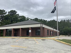
Post office
|
|||
|
|||
| Country | United States | ||
| State | North Carolina | ||
| County | Brunswick | ||
| Incorporated | 1899 | ||
| Area | |||
| • Total | 9.30 sq mi (24.10 km2) | ||
| • Land | 9.24 sq mi (23.93 km2) | ||
| • Water | 0.06 sq mi (0.16 km2) | ||
| Elevation | 26 ft (8 m) | ||
| Population
(2020)
|
|||
| • Total | 4,185 | ||
| • Density | 452.92/sq mi (174.86/km2) | ||
| Time zone | UTC−5 (Eastern Standard) | ||
| • Summer (DST) | UTC−4 (Eastern Daylight) | ||
| ZIP code |
28470
|
||
| Area codes | 910, 472 | ||
| FIPS code | 37-60800 | ||
| GNIS feature ID | 2407319 | ||
Shallotte is a town located in western Brunswick County, North Carolina, in the United States. It's pronounced like shuh-LOHT. The Shallotte River flows right through the town. In 2020, about 4,185 people lived here.
Contents
History of Shallotte
Shallotte became an official town in 1899. This means it was given the power to govern itself.
A former Hardee's restaurant in Shallotte was used for filming. It appeared in the movie Tammy (2014) starring Melissa McCarthy. The building was taken down in 2017.
Geography and Location
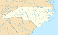
Shallotte is in the west-central part of Brunswick County. U.S. Route 17, also known as Ocean Highway, goes through the town. This main road helps people travel easily.
US 17 goes northeast about 33 miles to Wilmington. It also goes southwest about 38 miles to Myrtle Beach, South Carolina.
The town covers a total area of about 9.3 square miles (24.2 square kilometers). Most of this area is land. A small part, about 0.06 square miles (0.2 square kilometers), is water.
Shallotte's Climate
Shallotte has a mild climate. Here is a summary of the average weather:
| Climate data for SHALLOTTE AG, NC, 1991-2020 normals | |||||||||||||
|---|---|---|---|---|---|---|---|---|---|---|---|---|---|
| Month | Jan | Feb | Mar | Apr | May | Jun | Jul | Aug | Sep | Oct | Nov | Dec | Year |
| Mean daily maximum °F (°C) | 55.6 (13.1) |
58.1 (14.5) |
65.2 (18.4) |
72.0 (22.2) |
78.4 (25.8) |
83.6 (28.7) |
87.2 (30.7) |
86.0 (30.0) |
82.4 (28.0) |
74.3 (23.5) |
65.2 (18.4) |
58.5 (14.7) |
72.2 (22.3) |
| Daily mean °F (°C) | 46.0 (7.8) |
48.3 (9.1) |
54.5 (12.5) |
62.5 (16.9) |
70.0 (21.1) |
76.5 (24.7) |
80.1 (26.7) |
78.9 (26.1) |
74.7 (23.7) |
65.2 (18.4) |
55.0 (12.8) |
48.9 (9.4) |
63.4 (17.4) |
| Mean daily minimum °F (°C) | 36.4 (2.4) |
38.6 (3.7) |
43.8 (6.6) |
52.9 (11.6) |
61.5 (16.4) |
69.3 (20.7) |
73.1 (22.8) |
71.8 (22.1) |
66.9 (19.4) |
56.0 (13.3) |
44.7 (7.1) |
39.4 (4.1) |
54.5 (12.5) |
| Average precipitation inches (mm) | 3.79 (96) |
3.58 (91) |
4.17 (106) |
3.52 (89) |
3.83 (97) |
4.48 (114) |
5.19 (132) |
6.87 (174) |
9.66 (245) |
4.24 (108) |
3.55 (90) |
3.65 (93) |
56.53 (1,436) |
| Average precipitation days (≥ 0.01 in) | 7.7 | 8.0 | 7.9 | 7.6 | 8.2 | 8.0 | 8.5 | 10.4 | 7.9 | 6.7 | 7.1 | 9.0 | 97.0 |
| Source: NOAA | |||||||||||||
Population and People
The population of Shallotte has grown over the years. Here's how it has changed:
| Historical population | |||
|---|---|---|---|
| Census | Pop. | %± | |
| 1900 | 149 | — | |
| 1910 | 139 | −6.7% | |
| 1920 | 174 | 25.2% | |
| 1930 | 214 | 23.0% | |
| 1940 | 381 | 78.0% | |
| 1950 | 493 | 29.4% | |
| 1960 | 480 | −2.6% | |
| 1970 | 597 | 24.4% | |
| 1980 | 680 | 13.9% | |
| 1990 | 965 | 41.9% | |
| 2000 | 1,381 | 43.1% | |
| 2010 | 3,675 | 166.1% | |
| 2020 | 4,185 | 13.9% | |
| U.S. Decennial Census | |||
2020 Census Information
In 2020, Shallotte had 4,185 people living there. There were 1,682 households and 1,066 families.
| Race | Number | Percentage |
|---|---|---|
| White (non-Hispanic) | 3,326 | 79.47% |
| Black or African American (non-Hispanic) | 399 | 9.53% |
| Native American | 32 | 0.76% |
| Asian | 53 | 1.27% |
| Pacific Islander | 3 | 0.07% |
| Other/Mixed | 189 | 4.52% |
| Hispanic or Latino | 183 | 4.37% |
2010 Census Information
According to the 2010 census, 3,675 people lived in Shallotte. There were 1,583 households. About 23.2% of these households had children under 18.
The average household had 2.24 people. The average family had 2.78 people.
The population was spread out by age:
- 22.8% were under 20 years old.
- 22.5% were between 20 and 40 years old.
- 32.2% were between 40 and 65 years old.
- 22.4% were 65 years or older.
The median age was 43.9 years. This means half the people were younger and half were older.
Local Media
- Brunswick Beacon: This is a weekly newspaper that covers news in the Shallotte area.
See also
 In Spanish: Shallotte (Carolina del Norte) para niños
 | Kyle Baker |
 | Joseph Yoakum |
 | Laura Wheeler Waring |
 | Henry Ossawa Tanner |


