New Hanover County, North Carolina facts for kids
Quick facts for kids
New Hanover County
|
|||
|---|---|---|---|

|
|||
|
|||
| Motto(s):
"The model of good governance"
|
|||

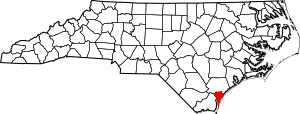
Location within the U.S. state of North Carolina
|
|||
 North Carolina's location within the U.S. |
|||
| Country | |||
| State | |||
| Founded | 1729 | ||
| Named for | House of Hanover | ||
| Seat | Wilmington | ||
| Largest community | Wilmington | ||
| Area | |||
| • Total | 328.86 sq mi (851.7 km2) | ||
| • Land | 192.26 sq mi (498.0 km2) | ||
| • Water | 136.60 sq mi (353.8 km2) 41.54% | ||
| Population
(2020)
|
|||
| • Total | 225,702 | ||
| • Estimate
(2023)
|
238,852 | ||
| • Density | 1,173.94/sq mi (453.26/km2) | ||
| Time zone | UTC−5 (Eastern) | ||
| • Summer (DST) | UTC−4 (EDT) | ||
| Congressional district | 7th | ||
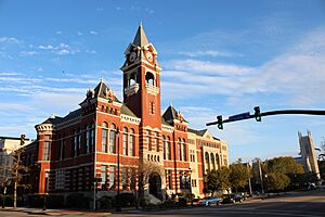
New Hanover County is a county in North Carolina, a state in the United States. In 2020, about 225,702 people lived here. The main city and county seat is Wilmington.
Even though New Hanover County is one of the smallest counties in North Carolina by land area, it has a large population. This is because Wilmington is one of the biggest cities in the state. The county started in 1729 as New Hanover Precinct. It became a full county in 1739. New Hanover County is part of the Wilmington, NC Metropolitan Area. This area also includes Pender and Brunswick counties.
Contents
History of New Hanover County
New Hanover County is located in the Low Country area of North Carolina. It was created in 1729 from Craven Precinct. The county was named after the House of Hanover. This was a German royal family that ruled Great Britain at the time.
Changes to County Borders
Over the years, parts of New Hanover County were used to form other counties. In 1734, parts became Bladen Precinct and Onslow Precinct. When Bath County was removed in 1739, all its smaller areas became counties.
In 1750, the northern part of New Hanover County became Duplin County. Later, in 1764, another part of New Hanover County joined with part of Bladen County to form Brunswick County. Finally, in 1875, the northern part became Pender County. This made New Hanover County its current size.
Life in the Early County
In the past, the county had many large farms called plantations. People grew crops like tobacco on these farms. Enslaved African Americans were forced to work on these plantations. By 1860, most people in the county and its main city were Black, and most of them were enslaved.
The Civil War and Its Aftermath
Some important battles of the American Civil War happened in this county. These included the Second Battle of Fort Fisher and the Battle of Wilmington. After the war, formerly enslaved people gained the right to vote. This made some white leaders unhappy.
After the Reconstruction era, white leaders in the state made new laws. These laws were called Jim Crow laws. They created a system where Black people were treated unfairly and had fewer rights.
The Wilmington Insurrection of 1898
A very serious event happened in Wilmington in 1898. A group of white leaders disagreed with the city's elected government, which included both Black and white officials. They planned to take over the government. Mobs attacked Black neighborhoods and residents. Many Black people were killed, and leaders were forced to leave the city. Black-owned businesses and a newspaper were destroyed.
One of the people involved in planning this event was Hugh MacRae. He later gave land to New Hanover County for a park. The park was named after him. A plaque at the park tells about his life but does not mention his role in the 1898 events.
Soon after, North Carolina passed a new state constitution. This made it very hard for Black people to register to vote. It took away their political power and forced them into a lower social status. These unfair rules lasted for many years, until the 1960s.
Geography and Natural Features
The U.S. Census Bureau says that New Hanover County covers about 328 square miles. About 192 square miles are land, and 137 square miles (42%) are water. It is the second-smallest county in North Carolina by land area. Only Chowan County is smaller.
Islands in the County
New Hanover County has several beautiful islands:
Neighboring Counties
New Hanover County shares borders with two other counties:
- Pender County to the north
- Brunswick County to the west
Main Roads and Highways
Several major roads run through New Hanover County:
 I-40
I-40
 I-140 / NC 140
 US 17
US 17
 US 17 Bus.
 US 74
US 74 US 76
US 76 US 117
 US 421


 US 421 Truck
 NC 132
 NC 133
 NC 211
Population and Demographics
| Historical population | |||
|---|---|---|---|
| Census | Pop. | %± | |
| 1790 | 6,837 | — | |
| 1800 | 7,060 | 3.3% | |
| 1810 | 11,465 | 62.4% | |
| 1820 | 10,866 | −5.2% | |
| 1830 | 10,959 | 0.9% | |
| 1840 | 13,312 | 21.5% | |
| 1850 | 17,668 | 32.7% | |
| 1860 | 21,715 | 22.9% | |
| 1870 | 27,978 | 28.8% | |
| 1880 | 21,376 | −23.6% | |
| 1890 | 24,026 | 12.4% | |
| 1900 | 25,785 | 7.3% | |
| 1910 | 32,037 | 24.2% | |
| 1920 | 40,620 | 26.8% | |
| 1930 | 43,010 | 5.9% | |
| 1940 | 47,935 | 11.5% | |
| 1950 | 63,272 | 32.0% | |
| 1960 | 71,742 | 13.4% | |
| 1970 | 82,996 | 15.7% | |
| 1980 | 103,471 | 24.7% | |
| 1990 | 120,284 | 16.2% | |
| 2000 | 160,307 | 33.3% | |
| 2010 | 202,667 | 26.4% | |
| 2020 | 225,702 | 11.4% | |
| 2023 (est.) | 238,852 | 17.9% | |
| U.S. Decennial Census 1790–1960 1900–1990 1990–2000 2010 2020 |
|||
Demographics tell us about the people living in an area, like their age, race, and how many households there are.
Population in 2020
| Race | Number | Percentage |
|---|---|---|
| White (non-Hispanic) | 167,150 | 74.06% |
| Black or African American (non-Hispanic) | 26,974 | 11.95% |
| Native American | 678 | 0.3% |
| Asian | 3,468 | 1.54% |
| Pacific Islander | 148 | 0.07% |
| Other/Mixed | 9,984 | 4.42% |
| Hispanic or Latino | 17,300 | 7.66% |
In 2020, the United States census counted 225,702 people living in New Hanover County. There were 100,189 households and 56,160 families.
Education in New Hanover County
The schools in the county are managed by New Hanover County Schools.
Healthcare Services
New Hanover Regional Medical Center is a hospital located in Wilmington. It opened in 1967 as a public hospital. It was the first hospital in the city to welcome patients of all races. New Hanover County used to operate it. In February 2021, a private, non-profit group called Novant Health took over the hospital.
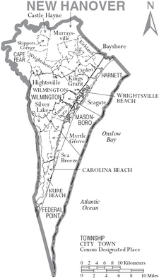
Communities in New Hanover County
New Hanover County has several different types of communities.
Cities
- Wilmington (This is the county seat, meaning it's the main city where the county government is located.)
Towns
Townships
Townships are smaller areas within a county, often used for local administration.
- Cape Fear
- Federal Point
- Harnett
- Masonboro
- Wilmington
Census-Designated Places (CDPs)
CDPs are areas that look like towns but are not officially incorporated as cities or towns.
Unincorporated Communities
These are small communities that are not part of any city or town.
Famous People from New Hanover County
- Michael Jordan, a famous NBA basketball player.
- Meadowlark Lemon, an NBA player known for playing with the Harlem Globetrotters.
See also
 In Spanish: Condado de New Hanover para niños
 | Victor J. Glover |
 | Yvonne Cagle |
 | Jeanette Epps |
 | Bernard A. Harris Jr. |


