
Wrightsville Beach, North Carolina facts for kids
Quick facts for kids
Wrightsville Beach, North Carolina
|
|||
|---|---|---|---|
_7_(cropped).jpg)
Wrightsville Beach shoreline seen from Crystal Pier
|
|||
|
|||

Location in New Hanover County and the state of North Carolina.
|
|||
| Country | United States | ||
| State | North Carolina | ||
| County | New Hanover | ||
| Township | Harnett Township | ||
| Named for | Joshua G. Wright | ||
| Area | |||
| • Total | 2.27 sq mi (5.89 km2) | ||
| • Land | 1.40 sq mi (3.61 km2) | ||
| • Water | 0.88 sq mi (2.28 km2) | ||
| Elevation | 0 ft (0 m) | ||
| Population
(2020)
|
|||
| • Total | 2,473 | ||
| • Density | 1,772.76/sq mi (684.67/km2) | ||
| Time zone | UTC-5 (Eastern (EST)) | ||
| • Summer (DST) | UTC-4 (EDT) | ||
| ZIP code |
28480
|
||
| Area codes | 910, 472 | ||
| FIPS code | 37-75820 | ||
| GNIS feature ID | 2406920 | ||


Wrightsville Beach is a town in New Hanover County, North Carolina, United States. It is located just east of Wilmington. The town is part of the larger Wilmington area.
In 2020, about 2,473 people lived here. Wrightsville Beach includes a 4-mile long beach island. It also has an island called Harbor Island and some shops on the mainland. You might know it as a place where the TV show Dawson's Creek was filmed!
Contents
History of Wrightsville Beach
How Wrightsville Beach Started
The first records of Wrightsville Beach go back to 1725. A man named Charles Harrison was given land by the Lords Proprietors. This land was about 640 acres. It was the first time anyone officially owned property near the beach.
In the 1700s and 1800s, the area called "the Hammocks" could be reached by a footbridge. But the beach itself could only be reached by boat.
In 1883, seven local men who loved sailing started the Carolina Yacht Club. It is one of the oldest yacht clubs in America. This was the first building on the beach. It could only be reached by boat at first. After that, a few small houses and shops started to appear. This area was then known as Ocean View Beach.
The town is named after Joshua G. Wright (1842-1890). He had a real estate company in Wilmington. A post office called Wrightsville opened in 1881. Getting to the beach became easier in 1887 when Shell Road was finished. This road went from Wilmington to the Intracoastal Waterway. In 1899, the town officially became Wrightsville Beach. It was named to honor the Wright family.

Growing and Developing the Beach
By the late 1800s, the MacRae family owned the land. In 1887, a train started bringing people from Wilmington to Bradley Creek. Then, in 1889, the Ocean View Railroad built tracks across Banks Channel. This brought visitors right to the oceanfront.
In 1902, Hugh MacRae helped create an electric streetcar system. This system brought people from downtown Wilmington to the beach. Cars were not allowed on Wrightsville Beach until the 1930s. This meant the streetcar was the main way to get around. The streetcars also carried things like ice, which helped new snack shops open.
The MacRae family began to develop Wrightsville Beach as a resort. They fixed up two hotels. In 1905, they built a huge entertainment place called Lumina. It had 6,000 lights that lit up the building. Lumina had a 25,000 square foot dance floor, games, food, and shows. Many famous musicians played there. In 1913, Lumina added a movie screen in the ocean to show silent films.
After World War II, Lumina became less popular. The streetcar service stopped in 1940. More entertainment places opened nearby. Lumina tried different things, like being a skating rink and then a bar. But it closed in 1972 and was torn down in 1973. Now, there are condominiums where Lumina used to be.
In 1923, Shell Island was bought to build a resort for African Americans. They built a pavilion, boardwalks, and shops. Visitors could take the streetcar to Harbor Island, then a ferry to Shell Island. But in 1926, a big fire destroyed everything on the island. It was never rebuilt.
In 1937, the Ocean View Pier was built. In 1939, Johnnie Mercer bought it and renamed it Johnnie Mercer's Pier. This pier has been damaged by many hurricanes. After Hurricane Fran in 1996, it was closed until 2002. The pier you see today is made of strong concrete.
Another pier, the Mira Mar Fishing Pier, was built in 1938. It was built over the wreck of an old ship from the Civil War. This shipwreck created a good spot for fishing. The Mira Mar Pier was 1,000 feet long and had a bowling alley and restaurant. It was later renamed the Crystal Fishing Pier.
Getting to the beach became much easier in 1935. A highway and car bridge were built. A road from the mainland to Harbor Island was built in 1926. This allowed people to drive to the first part of the beach. The new bridge over Banks Channel allowed cars to reach the town easily. On April 18, 1939, the last electric streetcar trip to Wrightsville Beach took place.
Storms and Hurricanes
Wrightsville Beach has faced many strong storms. Two big hurricanes hit in 1899. The first one hit on August 17, causing a lot of damage. The second storm came on November 1. Many buildings on the island were damaged. Houses were swept away, and the Carolina Yacht Club had to be rebuilt.
In 1954, Hurricane Hazel hit. This was a very strong Category 4 hurricane. It caused a lot of damage along the coast, including Wrightsville Beach. Hurricane Connie hit in 1955. It damaged Johnnie Mercer's Pier and some houses.
In 1996, two hurricanes, Bertha and Fran, hit within a few months. These storms destroyed the fishing piers. They caused hundreds of thousands of dollars in damage.
In 1999, Hurricane Dennis brought heavy rains and strong winds. This storm set the stage for the terrible flooding that Hurricane Floyd caused weeks later.
Most recently, Hurricane Florence hit Wrightsville Beach in 2018. It was a Category 1 storm with winds up to 90 mph.
Historic Places to See
Wrightsville Beach has several places listed on the National Register of Historic Places. These are important sites that tell about the area's past.
- Bradley-Latimer Summer House
- Cape Fear Civil War Shipwreck Discontiguous District
- Mount Lebanon Chapel and Cemetery
- James D. and Frances Sprunt Cottage
Geography of the Area
Wrightsville Beach is made up of two islands. These islands are separated by water. Bradley Creek runs between the mainland and Harbor Island. Harbor Island is then separated from the main beach by Banks Channel.
To the north of Wrightsville Beach is Figure Eight Island. They are separated by Mason's Inlet. To the south is Masonboro Island, separated by Masonboro Inlet.
The town covers about 2.4 square miles (6.2 square kilometers). About 1.3 square miles (3.4 square kilometers) is land. The rest, about 1.1 square miles (2.8 square kilometers), is water.
Population Information
| Historical population | |||
|---|---|---|---|
| Census | Pop. | %± | |
| 1900 | 22 | — | |
| 1910 | 54 | 145.5% | |
| 1920 | 20 | −63.0% | |
| 1930 | 109 | 445.0% | |
| 1940 | 252 | 131.2% | |
| 1950 | 711 | 182.1% | |
| 1960 | 723 | 1.7% | |
| 1970 | 1,701 | 135.3% | |
| 1980 | 2,910 | 71.1% | |
| 1990 | 2,937 | 0.9% | |
| 2000 | 2,593 | −11.7% | |
| 2010 | 2,477 | −4.5% | |
| 2020 | 2,473 | −0.2% | |
| U.S. Decennial Census | |||
Who Lives in Wrightsville Beach?
| Race | Number | Percentage |
|---|---|---|
| White (non-Hispanic) | 2,322 | 93.89% |
| Black or African American (non-Hispanic) | 11 | 0.44% |
| Asian | 15 | 0.61% |
| Pacific Islander | 1 | 0.04% |
| Other/Mixed | 89 | 3.6% |
| Hispanic or Latino | 35 | 1.42% |
According to the 2020 United States census, there were 2,473 people living in Wrightsville Beach. There were 1,166 households and 531 families.
Images for kids
-
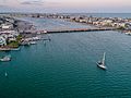
Wrightsville Beach Aerial Photo showing the Intracoastal Waterway
-

A modern home in Wrightsville Beach, North Carolina
-
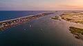
Aerial view of the south end of Wrightsville Beach, North Carolina
-
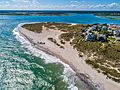
The south end of Wrightsville Beach
-
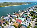
A neighborhood in Wrightsville Beach


See also
 In Spanish: Wrightsville Beach para niños
