Pender County, North Carolina facts for kids
Quick facts for kids
Pender County
|
|||
|---|---|---|---|

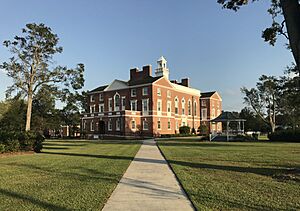
Pender County Courthouse in Burgaw
|
|||
|
|||
| Motto(s):
"Find Your Treasure"
|
|||

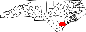
Location within the U.S. state of North Carolina
|
|||
 North Carolina's location within the U.S. |
|||
| Country | |||
| State | |||
| Founded | 1875 | ||
| Named for | William Dorsey Pender | ||
| Seat | Burgaw | ||
| Largest community | Hampstead | ||
| Area | |||
| • Total | 934.17 sq mi (2,419.5 km2) | ||
| • Land | 871.30 sq mi (2,256.7 km2) | ||
| • Water | 62.87 sq mi (162.8 km2) 6.73% | ||
| Population
(2020)
|
|||
| • Total | 60,203 | ||
| • Estimate
(2023)
|
68,521 | ||
| • Density | 69.10/sq mi (26.68/km2) | ||
| Time zone | UTC−5 (Eastern) | ||
| • Summer (DST) | UTC−4 (EDT) | ||
| Congressional district | 7th | ||
Pender County is a county located in the state of North Carolina, USA. In 2020, about 60,203 people lived here. The main town and government center is Burgaw. Pender County is part of the larger Wilmington area.
Contents
History of Pender County
Pender County was created in 1875. It was formed from parts of New Hanover County. The county is named after William Dorsey Pender. He was a general from Edgecombe County during the Civil War. He was badly hurt in the Battle of Gettysburg.
Pender County is in the southeastern part of North Carolina. It shares borders with seven other counties. The Atlantic Ocean is on its eastern side. The county's land area is about 870 square miles. The number of people living here has doubled since 1990.
When the county was first formed, leaders were told to meet in Rocky Point. The town of Cowan was supposed to be the county seat. But in 1877, a new law was passed. Voters got to choose if the county seat should move to South Washington or another spot. The chosen town would be called Stanford. In 1879, Stanford's name was changed to Burgaw, which is still the county seat today.
In 2021, a historic burial ground was disturbed by construction. This site was used by the community of Cardinal Acres until around 1950.
Geography and Nature
The U.S. Census Bureau says Pender County covers about 934 square miles. Most of this is land (about 871 square miles). The rest is water (about 63 square miles). Pender County is the fifth-largest county in North Carolina by land area.
Protected Natural Areas
Pender County has several special places that are protected. These areas help keep nature safe.
National Protected Area
State and Local Protected Areas
- Angola Bay Game Land (part)
- Cape Fear River Wetlands Game Land (part)
- Holly Shelter Game Land
- Lea-Hutaff Island State Natural Area
- Sandy Run Savannas State Natural Area (part)
- Whitehall Plantation Game Land (part)
Major Water Bodies
Pender County has many important rivers and water areas.
- Atlantic Ocean (North Atlantic Ocean)
- Black River: This river is home to some of the oldest known bald cypress trees. One tree is over 2,600 years old!
- Cape Fear River
- Doctor's Creek
- Intracoastal Waterway
- Island Creek
- Northeast Cape Fear River
- Onslow Bay
Neighboring Counties
Pender County shares its borders with these counties:
- Duplin County – to the north
- Onslow County – to the northeast
- New Hanover County – to the south
- Brunswick County – to the south
- Columbus County – to the southwest
- Bladen County – to the west
- Sampson County – to the northwest
Main Roads
 I-40
I-40 US 17
US 17
 US 17 Byp. (future Hampstead Bypass)
 US 117
 US 421
 NC 11
NC 11 NC 50
NC 50 NC 53
NC 53 NC 133
 NC 210
Population Information
| Historical population | |||
|---|---|---|---|
| Census | Pop. | %± | |
| 1880 | 12,468 | — | |
| 1890 | 12,514 | 0.4% | |
| 1900 | 13,381 | 6.9% | |
| 1910 | 15,471 | 15.6% | |
| 1920 | 14,788 | −4.4% | |
| 1930 | 15,686 | 6.1% | |
| 1940 | 17,710 | 12.9% | |
| 1950 | 18,423 | 4.0% | |
| 1960 | 18,508 | 0.5% | |
| 1970 | 18,149 | −1.9% | |
| 1980 | 22,215 | 22.4% | |
| 1990 | 28,855 | 29.9% | |
| 2000 | 41,082 | 42.4% | |
| 2010 | 52,217 | 27.1% | |
| 2020 | 60,203 | 15.3% | |
| 2023 (est.) | 68,521 | 31.2% | |
| U.S. Decennial Census 1790–1960 1900–1990 1990–2000 2010 2020 |
|||
2020 Census Details
In 2020, the census counted 60,203 people living in Pender County. There were 21,740 households and 14,676 families.
| Group | Number | Percentage |
|---|---|---|
| White (not Hispanic) | 44,418 | 73.78% |
| Black or African American (not Hispanic) | 7,544 | 12.53% |
| Native American | 195 | 0.32% |
| Asian | 319 | 0.53% |
| Pacific Islander | 23 | 0.04% |
| Other/Mixed | 2,722 | 4.52% |
| Hispanic or Latino | 4,982 | 8.28% |
Education
The schools in Pender County are managed by Pender County Schools.
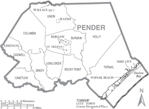
Communities in Pender County
Towns
Village
Townships
- Burgaw
- Canetuck
- Caswell
- Columbia
- Grady
- Holly
- Long Creek
- Rocky Point
- Topsail
- Union
Census-Designated Places
These are areas that are like towns but are not officially incorporated.
- Hampstead (This is the largest community)
- Long Creek
- Rocky Point
Other Unincorporated Communities
These are smaller communities that are not officially part of a town or village.
- Charity
- Currie
- Montague
- Register
- Scotts Hill
- Sloop Point
- Willard
- Yamacraw
Notable People from Pender County
- John Baptista Ashe: Born in Rocky Point, he was a delegate to the Continental Congress. This was an important meeting before the United States was formed.
- John Baptista Ashe: Also born in Rocky Point, he was a United States Congressman from North Carolina. He was the nephew of the first John Baptista Ashe.
- William Shepperd Ashe: Born in Rocky Point, he was also a United States Congressman from North Carolina.
See also
 In Spanish: Condado de Pender para niños
 | Selma Burke |
 | Pauline Powell Burns |
 | Frederick J. Brown |
 | Robert Blackburn |


