
Moores Creek National Battlefield facts for kids
Quick facts for kids Moores Creek National Battlefield |
|
|---|---|
.jpg)
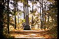
The reconstructed bridge at Moores Creek
|
|

Moores Creek National Battlefield
Location in North Carolina

Moores Creek National Battlefield
Location in the United States
|
|
| Location | Pender County, North Carolina, United States |
| Nearest city | Wilmington, North Carolina |
| Area | 88 acres (36 ha) |
| Established | June 2, 1926 |
| Visitors | 48,406 (in 2005) |
| Governing body | National Park Service |
| Website | Moores Creek National Battlefield |
|
Moore's Creek National Military Park
|
|
| Nearest city | Wilmington, North Carolina |
| Area | 44.3 acres (17.9 ha) |
| Built | 1776 |
| NRHP reference No. | 66000070 (original) 86003649 (increase) |
| Significant dates | |
| Added to NRHP | October 15, 1966 |
| Boundary increase | February 13, 1987 |
Moores Creek National Battlefield is a special place managed by the National Park Service. It remembers an important battle from 1776 during the American Revolution. In this battle, about a thousand American Patriots won against around eight hundred Loyalists.
This victory was a big deal! It stopped the British governor, Josiah Martin, from taking back control of North Carolina. It also ended British plans to land troops in Brunswick Town. The battle happened near Wilmington in Pender County. Just a few months later, on July 4, 1776, the Second Continental Congress decided to declare independence from Britain. The site became a national park on June 2, 1926, and was renamed a national battlefield on September 8, 1980.
Contents
The Battle of Moores Creek Bridge
The Battle of Moores Creek Bridge took place on February 27, 1776. Most of the Loyalists were Scottish, and many didn't even have guns. They carried broadswords instead. They thought they would only find a small group of Patriots.
A Clever Patriot Plan
Before the Loyalists arrived, the Patriots had a smart idea. They removed the wooden planks from the bridge over Moores Creek. Then, they smeared the remaining support beams with lard. This made the bridge very slippery! The Loyalists had to cross one by one, making them easy targets.
The Fight and Victory
As the Loyalists tried to cross the slippery bridge, Patriot shots rang out. Dozens of Loyalists fell into the creek, which was about six feet deep. Their leaders were also hit. Lieutenant Colonel Donald McLeod died in the battle. Another leader was Colonel Allan MacDonald, whose wife, Flora MacDonald, was a famous Scottish woman.
The Loyalists were shocked and confused. They had lost their leaders and were outgunned. Many quickly surrendered or ran away. After the battle, the Patriots captured wagons, weapons, and British money. This money would be worth over $1 million today!
Why This Battle Was Important
This amazing victory ended British power in North Carolina. It helped North Carolina become the first colony to vote for independence. The Battle of Moores Creek Bridge, along with the Battle of Sullivan's Island in South Carolina a few months later, were the first big fights of the American Revolution. These battles helped lead the Thirteen Colonies to declare independence on July 4, 1776.
Visiting Moores Creek National Battlefield

The creek at the park was likely named after Elizabeth Moore, an early settler.
Today, you can explore the park and see parts of the old road from 1776. Both Patriot and Loyalist soldiers traveled on this road. There's a 1-mile (1.6-km) trail with signs that explain what happened. This trail crosses Moores Creek where the historic bridge once stood.
The park is in a quiet, rural area. It has a visitor center with exhibits and a video about the battle. You can also walk a 0.3-mile (500 m) forest trail and enjoy a picnic area. It's a great place to learn about an important part of American history!
Images for kids
-

Moores Creek Drive
-

Visitor Center
-

Reconstructed earthworks
-
Loyalists Monument


