Surf City, North Carolina facts for kids
Quick facts for kids
Surf City, North Carolina
|
|||
|---|---|---|---|

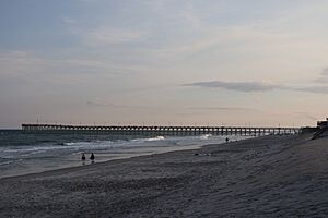
Surf City Ocean Pier
|
|||
|
|||
| Motto(s):
"Big enough to be competitive, small enough to be happy!"
|
|||
 |
|||
| Country | United States | ||
| State | North Carolina | ||
| Counties | Pender, Onslow | ||
| Incorporated (town) | 1949 | ||
| Government | |||
| • Type | Municipality | ||
| Area | |||
| • Total | 9.88 sq mi (25.60 km2) | ||
| • Land | 7.61 sq mi (19.70 km2) | ||
| • Water | 2.28 sq mi (5.90 km2) 20.4% | ||
| Elevation | 0 ft (0 m) | ||
| Population
(2020)
|
|||
| • Total | 3,867 | ||
| • Density | 508.48/sq mi (196.33/km2) | ||
| Time zone | UTC-5 (EST) | ||
| • Summer (DST) | UTC-4 (EDT) | ||
| ZIP code |
28445 & 28443
|
||
| Area codes | 910, 472 | ||
| FIPS code | 37-66040 | ||
| GNIS feature ID | 2406694 | ||
Surf City is a fun town in North Carolina, a state in the United States. It's special because it's located on a beautiful place called Topsail Island. This town is split between two counties: Onslow County and Pender County. In 2020, about 3,867 people lived here. The part of Surf City in Pender County is near the bigger city of Wilmington. The part in Onslow County is closer to Jacksonville.
Contents
Exploring Surf City's Location
Surf City is a coastal town. It covers about 5.3 square miles (13.7 square kilometers). Most of this area, about 4.2 square miles (10.9 square kilometers), is land. The rest, about 1.1 square miles (2.8 square kilometers), is water. This means a good part of the town is made up of water, like rivers or parts of the ocean.
Weather in Surf City
Surf City has a mild climate. This means it doesn't get too hot or too cold.
| Climate data for SURF CITY, NC, 1991-2020 normals | |||||||||||||
|---|---|---|---|---|---|---|---|---|---|---|---|---|---|
| Month | Jan | Feb | Mar | Apr | May | Jun | Jul | Aug | Sep | Oct | Nov | Dec | Year |
| Mean daily maximum °F (°C) | 54.8 (12.7) |
56.7 (13.7) |
63.3 (17.4) |
71.6 (22.0) |
78.3 (25.7) |
84.2 (29.0) |
87.5 (30.8) |
86.7 (30.4) |
82.1 (27.8) |
74.4 (23.6) |
65.8 (18.8) |
58.6 (14.8) |
72.0 (22.2) |
| Daily mean °F (°C) | 44.2 (6.8) |
46.2 (7.9) |
51.7 (10.9) |
60.9 (16.1) |
68.7 (20.4) |
75.9 (24.4) |
79.5 (26.4) |
78.5 (25.8) |
73.7 (23.2) |
64.1 (17.8) |
54.5 (12.5) |
47.3 (8.5) |
62.1 (16.7) |
| Mean daily minimum °F (°C) | 33.7 (0.9) |
35.7 (2.1) |
40.2 (4.6) |
50.3 (10.2) |
59.1 (15.1) |
67.5 (19.7) |
71.5 (21.9) |
70.3 (21.3) |
65.2 (18.4) |
53.8 (12.1) |
43.2 (6.2) |
36.0 (2.2) |
52.2 (11.2) |
| Average precipitation inches (mm) | 0.00 (0.00) |
0.00 (0.00) |
0.00 (0.00) |
0.00 (0.00) |
0.00 (0.00) |
0.00 (0.00) |
0.00 (0.00) |
0.00 (0.00) |
0.00 (0.00) |
0.00 (0.00) |
0.00 (0.00) |
0.00 (0.00) |
0.00 (0.00) |
| Average precipitation days (≥ 0.01 in) | 0.0 | 0.0 | 0.0 | 0.0 | 0.0 | 0.0 | 0.0 | 0.0 | 0.0 | 0.0 | 0.0 | 0.0 | 0.0 |
| Source: NOAA | |||||||||||||
How Surf City's Population Has Grown
The number of people living in Surf City has grown a lot over the years. Here's a quick look at how the population has changed:
| Historical population | |||
|---|---|---|---|
| Census | Pop. | %± | |
| 1970 | 166 | — | |
| 1980 | 421 | 153.6% | |
| 1990 | 970 | 130.4% | |
| 2000 | 1,393 | 43.6% | |
| 2010 | 1,853 | 33.0% | |
| 2020 | 3,867 | 108.7% | |
| U.S. Decennial Census | |||
People Living in Surf City (2020)
In 2020, a census was taken to count everyone in the town. Here's what they found about the different groups of people living in Surf City:
| Group | Number | Percentage |
|---|---|---|
| White (not Hispanic) | 3,337 | 86.29% |
| Black or African American (not Hispanic) | 42 | 1.09% |
| Native American | 8 | 0.21% |
| Asian | 46 | 1.19% |
| Pacific Islander | 2 | 0.05% |
| Other/Mixed | 221 | 5.72% |
| Hispanic or Latino | 211 | 5.46% |
As of the 2020 United States census, there were 3,867 people living in Surf City. These people made up 1,272 households, and 870 of those were families.
Ocean Piers in Surf City
Piers are long structures that stretch out over the water. They are great for fishing or just enjoying the view. Here are some of the piers in Surf City, listed from south to north:
- Surf City Pier: The last 150 feet of this pier, including a special octagon shape, was damaged by Hurricane Florence.
- Barnacle Bill's Pier: This pier was destroyed by Hurricane Fran.
- Scotch Bonnet Pier: This pier was also destroyed by Hurricane Fran.
- Ocean City Pier: This pier was also destroyed by Hurricane Fran.
Connecting Surf City: The Bridges
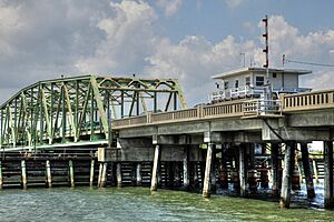
For many years, the main way to get to Surf City by road was over the Topsail Island Swing Bridge. This bridge was built in 1954. It was a "swing-span" bridge, meaning a part of it could swing open to let boats pass through the Intracoastal Waterway.
Over time, the old swing bridge started to wear out. So, in 2010, plans began to build a new bridge. Construction started in September 2016. The new bridge opened in December 2018, which was a whole year earlier than expected!
This new bridge cost about $54 million. It's a "fixed-span high rise" bridge, which means it doesn't open. It's 3,800 feet (about 1,158 meters) long and is 65 feet (about 20 meters) high above the water. This height allows boats to pass underneath at any time without stopping traffic. It also helps traffic flow much better.
The new bridge is 50 feet (about 15 meters) wide. It has two lanes for cars, special lanes for bicycles on the shoulders, and a path for walking or biking. The bridge was designed to be extra wide so that if there's a hurricane, it can have three lanes for people to evacuate safely. The old bridge was taken down by March 31, 2019. The town even kept parts of the old bridge, like the control panel and a cornerstone, to display in the new Town Hall as a historical reminder.
See also
 In Spanish: Surf City para niños
 | Aaron Henry |
 | T. R. M. Howard |
 | Jesse Jackson |


