
Topsail Island facts for kids

Topsail Island sound side
|
|

Topsail Island
Location in North Carolina

Topsail Island
Location in the United States
|
|
| Geography | |
|---|---|
| Location | Atlantic Ocean |
| Coordinates | 34°28′11″N 77°28′19″W / 34.46972°N 77.47194°W |
| Length | 26 mi (42 km) |
| Administration | |
|
US
|
|
Topsail Island (pronounced /ˈtɑːpsɪl/) is a beautiful 26-mile (41.8 km) long island off the coast of North Carolina. It's a special kind of island called a barrier island, which means it helps protect the mainland from ocean storms. Topsail Island is located between the Crystal Coast and the Cape Fear area, south of Jacksonville, North Carolina and Camp Lejeune. The island is separated from the mainland by calm waters and channels that are part of the Atlantic Intracoastal Waterway.

Topsail Island is home to three towns: North Topsail Beach, Surf City, and Topsail Beach. The island is famous for its thick maritime forests, stunning beaches, and as a safe haven for sea turtles. It stretches across parts of Onslow County in the north and Pender County in the south. You can reach the island by two high-rise bridges, one in Surf City and another in North Topsail Beach. The island is also known for its interesting corals and fossils.
Contents
What's in a Name?
The name Topsail Island has a fun story! People say it comes from the days of pirates. Long ago, pirates would hide their ships in the channels near the island. They hoped to surprise and capture merchant ships sailing by. When sailors learned about this trick, they started calling it "Topsail Island." This was because the topsail (the highest sail) of a pirate ship was often the only part visible, hinting at a hidden ambush.
A Look Back in Time
Topsail Island has a rich history, full of changes and interesting events.
Before World War II
Before World War II, Topsail Island was a quiet place only reachable by boat. Local families often visited for picnics on the sandy beaches. Farmers sometimes guided their animals across the shallow waterways at low tide to graze on the wild grass. Some people even searched the island's forests for the legendary buried treasure of the pirate Blackbeard! In the early 1900s, only a few small buildings existed, mostly used by fishermen and summer vacationers.
Topsail Island During World War II
When World War II began, the U.S. Army took over the island. They built a large training base called Camp Davis nearby in Holly Ridge. The Army constructed a road from Camp Davis to the sound and put in a temporary bridge across the Atlantic Intracoastal Waterway. This bridge was later replaced by a permanent one in the 1950s, which was then updated to a fixed high-rise bridge in 2018. The Army also built training facilities in what is now the Surf City area.
After the War: Operation Bumblebee
Right after the war, the US Navy used Topsail Island for a top-secret project called Operation Bumblebee. This was a joint effort with Johns Hopkins University to develop and test early guided missiles. Over 200 missiles were launched from the island! The building where missiles were put together is now a museum and meeting center in Topsail Beach. The old launch pad is now a patio for a motel, and some of the tall towers used to track the missiles can still be seen today. This testing ended in 1948.
Rebuilding After Hurricane Hazel
After the Navy left, the island was returned to its original owners, and people started developing it as a beach resort in the 1950s. A developer even built a special brick model home in 1952. However, in 1954, a powerful storm called Hurricane Hazel caused a huge flood that covered the entire island and washed away most buildings. The model home survived with only minor damage. Because of the hurricane, new homes were designed to be built on tall stilts (pilings) to protect them from future floods. That original model home still stands today in Topsail Beach.
Home to Sea Turtles
Topsail Island is a very important place for sea turtles. These amazing creatures are facing challenges, and their populations are decreasing because of changes to their habitats and more people living near their nesting areas.
Protecting Our Ocean Friends
Four main types of sea turtles visit Topsail Island: loggerhead, green, leatherback, and Ridley sea turtles. The Loggerhead Sea Turtle is especially important here. Topsail Island is home to the Sea Turtle Rescue and Rehabilitation Center. Their mission is to protect the 26-mile stretch of beach on Topsail Island. They carefully watch over nesting sites, help sick or injured turtles, and ensure that baby turtles hatch safely.
Hurricanes can also affect sea turtle nesting sites. Strong storms can change the beach sand, making it harder for turtles to find good places to lay their eggs. Sometimes, eggs can even be washed away by floodwaters. However, the number of eggs laid is usually very high, so the overall impact on the population might not be too big. All five species of sea turtles are protected by law as endangered species.
The Topsail Turtle Project
The Topsail Turtle Project started because sea turtles have been nesting on this island for hundreds of years. What began with a few dedicated volunteers has grown into a large effort. Karen Beasley founded the project, and her dream was to protect these turtles. Volunteers would walk the beaches at night, marking nesting sites and watching over the eggs until they hatched. After Karen passed away in 1991, her mother, Jean Beasley, took over. Jean continues to lead the project today, ensuring the turtles of Topsail Island are cared for.
Secret Missile Tests: Operation Bumblebee
As we learned, after World War II, the U.S. Navy and Johns Hopkins University worked together on Operation Bumblebee on Topsail Island. This was a top-secret project to develop and test new ramjet missiles. These tests were very important for advancing jet aircraft and missile technology in the United States. The project helped pave the way for supersonic jet aircraft and modern space technology. The name 'Bumblebee' was chosen, perhaps because bumblebees seem to fly even though it looks like they shouldn't be able to!
Operation Bumblebee brought many changes to Topsail Island. The waterway was deepened, new roads were built, and fresh water was piped onto the island. Topsail Island was the first permanent site for missile testing in the U.S. The buildings constructed for this testing, like the Assembly Building, Facility Control Tower, and Observation Tower No. 2, are very important historical landmarks. They are the only remaining above-ground structures from these early missile testing sites. The Assembly Building is a brick building, and the Control Tower is made of reinforced concrete. Observation Tower #2 is still in its original condition. Some other towers were turned into houses, and one became a restaurant, but some were damaged by storms over the years. The concrete launch pad where missiles were fired is now a patio at the Jolly Roger Motel.
About 500 Navy and Marine personnel worked on the island during the 18 months of testing. They built and launched around 200 experimental rockets. Even though the tests were successful, the location wasn't perfect for a permanent base because of weather and increasing boat traffic. So, the equipment was moved to other sites.
Getting Around Topsail Island
Two main state highways run along Topsail Island and meet in Surf City, which is right in the middle of the island.
- NC 50: This road goes from the Surf City Bridge south to the very tip of the island in Topsail Beach.
- NC 210: This road goes from the Surf City Bridge north to North Topsail Beach, and then across the North Topsail Bridge.
Images for kids
-
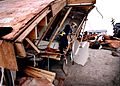
North Topsail Beach, September 6, 1996 — An Urban Search and Rescue (USAR) Team inspects damaged and destroyed homes after Hurricane Fran
-
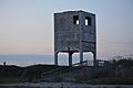
Observation tower on Topsail Island left over from Operation Bumblebee


