Black River (North Carolina) facts for kids
Quick facts for kids Black River |
|
|---|---|
 |
|
|
Location of Black River mouth
|
|
| Other name(s) | Tributary to Cape Fear River |
| Country | United States |
| State | North Carolina |
| Counties | Bladen Pender Sampson |
| Physical characteristics | |
| Main source | confluence of Six Runs Creek and Great Coharie Creek about 3 NW of Clear Run, North Carolina 44 ft (13 m) 34°47′23″N 078°18′45″W / 34.78972°N 78.31250°W |
| River mouth | Cape Fear River Wilmington, North Carolina 0 ft (0 m) 34°19′55″N 078°01′57″W / 34.33194°N 78.03250°W |
| Length | 53.1 mi (85.5 km) |
| Basin features | |
| Progression | generally southeast |
| River system | Cape Fear River |
| Basin size | 1,417.37 square miles (3,671.0 km2) |
| Tributaries |
|
The Black River is a cool river in southeastern North Carolina, United States. It's about 50 miles (80 km) long. It flows into the Cape Fear River.
The Black River starts in Sampson County. It forms when two creeks, Great Coharie Creek and Six Runs Creek, join together. The river then flows southeast through Pender County. It passes by the Moores Creek National Battlefield. Finally, it joins the Cape Fear River near Wilmington.
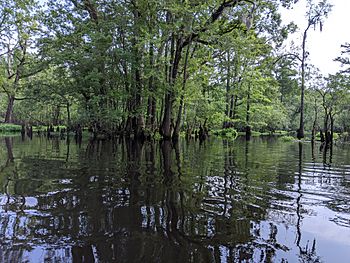
This river is home to many kinds of fish. You can find different types of sunfish, catfish, and largemouth bass here. What's really special are the ancient Bald cypress trees along the river. Some of these trees are over 2,600 years old!
Contents
River History: Boats & Travel
Long ago, Native Americans used canoes to travel along the Black River. This was how they moved through the area.
After the Civil War, in the 1800s, the U.S. Army Corps of Engineers helped make the river deeper. This allowed steamboats to use the river. Steamboats made it easier to move things like lumber, grains, and farm animals by boat.
Exploring the Black River's Geography
Three Sisters Swamp: Ancient Trees
The Three Sisters swamp is a special place on the Black River. It's located in Bladen County. You can only reach this swamp by canoe or kayak.
This swamp is about one mile long and half a mile wide. It holds the largest group of very old cypress trees in the entire Black River Preserve. It's like a secret forest of ancient giants!
Ecology: Life in the Blackwater River
The Black River is a type of blackwater river. This means its water looks dark, like tea. This color comes from decaying plants that release natural dyes called tannins into the water.
Blackwater rivers have less nutrients and are more acidic. This environment is unique. It doesn't support all types of trees, and it even slows the growth of bald cypress trees. But, these rivers have their own special kinds of plants and animals.
Rare Fish Species
Two rare fish species live in the Black River. One is the Santee chub (Cyprinella zanema). The other is the Broadtail Madtom. Even though they are rare, they are not currently considered endangered.
Discovering Ancient Bald Cypress Trees
The Black River in North Carolina is the only place in the world where bald cypress trees have lived for over a thousand years. In 2019, scientists found a tree here that started growing in 605 B.C.E.!
These ancient bald cypress trees are the oldest trees in eastern North America. They are also the fifth oldest type of tree on Earth.
How Scientists Date Ancient Trees
Scientists use special methods to figure out how old these trees are. They use a method that combines radiocarbon dating and dendrochronology. Dendrochronology is the study of tree rings.
A scientist named David Stahle used this technology. He helped date some of the oldest cypress trees in the Three Sisters swamp area. This information helps us understand how the Black River ecosystem has changed over time. It shows how it adapted to different climates and rainfall patterns.
Fun Activities: Recreation on the River
In 1994, the Black River was named an "Outstanding Water Source." This was done by the North Carolina Division of Parks and Recreation. Since then, it has become a popular spot for outdoor fun.
Many people enjoy kayaking and canoeing on the river. All year long, people in boats can see many different plants and animals along the riverbanks. It's a great place for nature lovers!
Protecting the Black River: Conservation Efforts
The Nature Conservancy (TNC) has been a big supporter of the Black River for a long time. TNC has helped set aside more than 17,000 acres for the Black River Preserve.
This project started in 1989 with help from North Carolina state agencies. Their goal is to protect the river and its surrounding environment.
Environmentalists are very focused on the Black River. This is because human activities can threaten its ecosystem. These threats include pollution, logging, climate change, and rising sea levels. Protecting this unique river is very important.
 | Sharif Bey |
 | Hale Woodruff |
 | Richmond Barthé |
 | Purvis Young |


