Northeast Cape Fear River facts for kids
Quick facts for kids Northeast Cape Fear River |
|
|---|---|

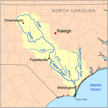
Map of the Cape Fear River drainage basin showing the Northeast Cape Fear River
|
|
|
Location of Northeast Cape Fear River mouth
|
|
| Other name(s) | Tributary to Cape Fear River |
| Country | United States |
| State | North Carolina |
| Counties | Duplin Lenoir New Hanover Pender Wayne |
| Physical characteristics | |
| Main source | divide between Northeast Cape Fear River and Goshen Swamp about 1 mile southeast of Mount Olive, North Carolina 146 ft (45 m) 35°10′19″N 078°02′36″W / 35.17194°N 78.04333°W |
| River mouth | Cape Fear River Wilmington, North Carolina 0 ft (0 m) 34°14′28″N 077°57′14″W / 34.24111°N 77.95389°W |
| Length | 131.25 mi (211.23 km) |
| Basin features | |
| Progression | south |
| River system | Cape Fear River |
| Basin size | 1,714.70 square miles (4,441.1 km2) |
| Tributaries |
|
The Northeast Cape Fear River is a long river in southeastern North Carolina, United States. It flows for about 131 miles (211 km). This river is a tributary to the larger Cape Fear River. This means it flows into the Cape Fear River, adding to its water.
Contents
River Names
The Northeast Cape Fear River has been known by a few other names over time. People sometimes called it the "North East River" or the "Northeast Fork."
Where the River Flows
The Northeast Cape Fear River starts near Mount Olive, North Carolina, in Wayne County. This is about 10 miles (16 km) south of Goldsboro. From there, it flows south.
As it travels, the river passes by small towns like Albertson, Hallsville, and Chinquapin. When it reaches Pender County, closer to the Atlantic Ocean, it flows alongside large swampy areas. These include the Angola Swamp and Holly Shelter Swamp.
Finally, the river joins the main Cape Fear River in Wilmington, North Carolina. Here, the two rivers form an estuary. An estuary is a place where fresh river water mixes with salty ocean water. The last 50 miles (80 km) of the river are affected by the ocean's tides. This means the water level goes up and down with the ocean.
The River's Watershed
A watershed is an area of land where all the water drains into a single river or body of water. The Northeast Cape Fear River's watershed covers a huge area of about 1,715 square miles (4,442 sq km).
This area gets a lot of rain, about 53.8 inches (137 cm) each year. About 19% of the land in this watershed is covered by forests. These forests help keep the river healthy by filtering water and preventing soil from washing away.
Amazing Animals and Plants
The Northeast Cape Fear River and its surrounding areas are home to many unique and interesting living things. You can find a variety of plants and animals here.
Some of the special plants include the palmetto, which looks like a small palm tree, and tall cypress trees. These trees often grow in wet, swampy areas.
The river is also home to exciting animals. You might spot an alligator, a large reptile that lives in the water. Birds like the pileated woodpecker, with its bright red crest, also live here. One of the most famous plants found in this region is the venus flytrap. This amazing plant actually eats insects! You can also find the bowfin, a type of fish that has been around for millions of years.
Bridges Over the River
Several bridges cross the Northeast Cape Fear River, helping people travel across it. These bridges are important parts of the local transportation system. They include:
- Isabelle S. Holmes Bridge (carrying US 74 and NC 133)
- Dan Cameron Bridge (part of I-140)
- Frank H. Kenan Bridge (part of I-40)
- Northeast Cape Fear Bridge (carrying US 117 and NC 133)
See also
 In Spanish: Noreste del río Cape Fear para niños
 | Jessica Watkins |
 | Robert Henry Lawrence Jr. |
 | Mae Jemison |
 | Sian Proctor |
 | Guion Bluford |


