
Sunset Beach, North Carolina facts for kids
Quick facts for kids
Sunset Beach, North Carolina
|
|||
|---|---|---|---|

Seagull over wave in Sunset Beach
|
|||
|
|||

Sunset Beach, North Carolina
Location in North Carolina
|
|||
| Country | United States | ||
| State | North Carolina | ||
| County | Brunswick | ||
| Township | Shallotte Township | ||
| Area | |||
| • Total | 7.88 sq mi (20.42 km2) | ||
| • Land | 6.97 sq mi (18.05 km2) | ||
| • Water | 0.92 sq mi (2.37 km2) | ||
| Elevation | 33 ft (10 m) | ||
| Population
(2020)
|
|||
| • Total | 4,175 | ||
| • Density | 599.17/sq mi (231.33/km2) | ||
| Time zone | UTC-5 (Eastern (EST)) | ||
| • Summer (DST) | UTC-4 (EDT) | ||
| ZIP code |
28468
|
||
| Area codes | 910, 472 | ||
| FIPS code | 37-65900 | ||
| GNIS feature ID | 2406693 | ||


Sunset Beach is a lovely seaside town located in Brunswick County, North Carolina, in the United States. It's known for being the most southern beach in North Carolina. In 2020, about 4,175 people lived there.
Contents
History of Sunset Beach
Sunset Beach started as a town in 1955. A man named Mannon C. Gore bought the land. He was very impressed by the beautiful sunsets he saw there. Because of this, he changed the name from 'Bald Beach' to 'Sunset Beach'.
Early Development and the First Bridge
Building the town really began in 1958. This was when a bridge was finished. It connected the beach island to the mainland. Mr. Gore designed and ran the bridge himself. Then, in 1961, the North Carolina Department of Transportation took it over.
With help from his son, Edward, Mr. Gore started selling land on the island in 1958. He also built the first pier on the island. It was called the 'Vesta Pier'. This name came from a Civil War ship. The ship had gotten stuck on the beach right under where the pier was built. Today, the ship is completely covered by sand. Sunset Beach officially became a town in 1963.
Recent Weather Events
On February 15, 2021, a strong tornado hit the northern part of town. It happened around midnight. Many homes in several neighborhoods were damaged. Some homes were even completely destroyed. This was a very serious event for the community.
Geography of Sunset Beach
Sunset Beach is found in the southwestern part of Brunswick County. It is the very last developed beach on the Atlantic Ocean before you reach the South Carolina border.
Island and Mainland Areas
About one-third of the town is on a barrier island. This island sits between the ocean and the Intracoastal Waterway. The rest of the town is on the mainland to the north.
To the west of Sunset Beach is Bird Island. This island is not developed. The closest town to the west on the mainland is Calabash. To the east is Ocean Isle Beach. It is just past Krause Point, which is the easternmost part of Sunset Beach.
Land and Water Area
The town of Sunset Beach covers a total area of about 19.0 square kilometers (7.3 square miles). Most of this area, about 16.7 square kilometers (6.4 square miles), is land. The remaining 2.3 square kilometers (0.9 square miles) is water. This means about 12.22% of the town's area is water.
Population of Sunset Beach
| Historical population | |||
|---|---|---|---|
| Census | Pop. | %± | |
| 1970 | 108 | — | |
| 1980 | 304 | 181.5% | |
| 1990 | 311 | 2.3% | |
| 2000 | 1,824 | 486.5% | |
| 2010 | 3,572 | 95.8% | |
| 2020 | 4,175 | 16.9% | |
| U.S. Decennial Census | |||
The population of Sunset Beach has grown quite a lot over the years. In 1970, only 108 people lived here. By 2020, the population had grown to 4,175 people. This shows how popular the town has become.
As of the 2020 United States census, there were 4,175 people living in Sunset Beach. These people made up 2,014 households and 1,289 families. Most of the residents are White (94.25%). There are also smaller numbers of Black or African American, Native American, Asian, Pacific Islander, and people of mixed races. About 2.3% of the population is Hispanic or Latino.
Sunset Beach Bridge


Most of Sunset Beach and the nearby Bird Island are on a barrier island. For a long time, the only way to get to the island from the mainland was by crossing a special pontoon bridge. This bridge could swing open to let boats pass.
The Old Swing Bridge
The old bridge was made of wood. It was only wide enough for one lane of traffic at a time. It was the last bridge of its kind still used on the East Coast until 2010.
During the summer, traffic would stop every hour. The bridge would open for 10 minutes to let boats go through the waterway. Then, it would reopen for cars for 50 minutes. In the off-season, the bridge only opened when boats needed to pass. While this could cause delays for drivers, many local people felt that the old bridge gave the town a more relaxed feeling. It helped keep Sunset Beach from growing too fast, unlike other beach towns nearby.
The New High-Rise Bridge
In February 2008, the NCDOT began building a new bridge. This new bridge is a modern, 65-foot (20 m) high arc bridge. It does not swing open. The new bridge opened on November 11, 2010.
The old Sunset Beach pontoon swing bridge was saved. A group called the Old Bridge Preservation Society plans to create a museum. This museum will celebrate the history of the old bridge and the town. The new bridge makes it easier for cars to get on and off the island. It also allows boats to move freely on the Intracoastal Waterway without stopping traffic.
Homes in Sunset Beach
The town of Sunset Beach has neighborhoods on both the mainland and the barrier island. The island has about 1,200 homes. Many of these are vacation rental homes and cottages. However, nearly 100 people live on the island full-time.
Mainland Neighborhoods
Some of the larger neighborhoods on the mainland are built around golf courses. These include Oyster Bay, Sea Trail Resort, and Sandpiper Bay. Another community, Ocean Ridge Plantation, has a clubhouse on the island for its members. Sea Trail Home Owners Association also has a special parking lot for its members on the island.
Images for kids
-
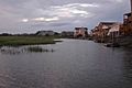
Beach houses at Sunset Beach at dusk
-
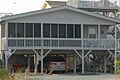
A beach house at Sunset Beach, NC named "SandTrap"


See also
 In Spanish: Sunset Beach (Carolina del Norte) para niños
