
Cape Cod Canal facts for kids
Quick facts for kids Cape Cod Canal |
|
|---|---|

The Bourne Bridge with the Cape Cod Canal Railroad Bridge in distance
|
|
| Coordinates | 41°45′51″N 70°34′06″W / 41.76417°N 70.56833°W |
| Specifications | |
| Length | 7 miles (11 km) |
| Status | Open |
| Navigation authority | United States Army Corps of Engineers |
| History | |
| Original owner | Cape Cod & New York Canal Company |
| Principal engineer | William Barclay Parsons |
| Construction began | June 22, 1909 |
| Date of first use | July 29, 1914 |
| Geography | |
| Start point | Cape Cod Bay |
| End point | Buzzards Bay |
| Length | 825 ft (251 m) |
| Beam | "size consistent with safe navigation as governed by the controlling depths and widths of the channel" (the canal is 480 ft (150 m) wide) |
| Height | 135 ft (41 m) |
| Draft | 32 ft (9.8 m) |
The Cape Cod Canal is a man-made waterway in Massachusetts. It connects Cape Cod Bay in the north to Buzzards Bay in the south. This canal is part of the Atlantic Intracoastal Waterway.
The canal is about seven-mile-long (11 km) and cuts through the narrow piece of land that connects Cape Cod to the rest of Massachusetts. Most of the canal follows natural tidal rivers. These rivers were made wider to 480 feet (150 m) and deeper to 32 feet (9.8 m). This shortcut saves ships 135 miles (217 km) of travel around Cape Cod. About 14,000 boats use the canal each year.
Most of the canal is in Bourne, Massachusetts. Its northern end is in Sandwich, Massachusetts. You can find Scusset Beach State Reservation near the north entrance. The Massachusetts Maritime Academy is close to the south entrance. The water in the canal has a strong current that changes direction every six hours. It can flow as fast as 5.2 miles per hour (8.4 km/h). The United States Army Corps of Engineers maintains the canal. There are no fees to use it.
Three bridges cross the canal: the Cape Cod Canal Railroad Bridge, the Bourne Bridge, and the Sagamore Bridge. Traffic lights at both ends help guide large ships (over 65 feet (20 m)) safely into the canal. Sometimes, whales and dolphins, including endangered North Atlantic right whales, use the canal. If they are present, the canal might be closed to protect them.


| Top - 0-9 A B C D E F G H I J K L M N O P Q R S T U V W X Y Z |
Building the Cape Cod Canal
People have thought about building a canal across Cape Cod for a very long time.
Early Ideas and Attempts
The idea for a canal first came up in 1623. Myles Standish of the Plymouth Colony and the Pilgrims looked at the low land between the Manomet and Scusset rivers. They thought it would be a good place for a canal. In 1627, William Bradford set up the Aptucxet Trading Post there. This helped trade with local American Indians and the Dutch.
In 1697, the General Court of Massachusetts officially considered building the canal. But they did not take any action. In 1717, a small canal called Jeremiah's Gutter was built further east. It was used until the late 1800s. Many surveys and plans for a canal were made between 1776 and 1860. Even George Washington looked into it. However, none of these plans worked out.
The first real attempts to build the canal happened in the late 1800s. Earlier builders often ran out of money. The project was simply too big for them. Engineers finally decided to connect and widen the Manomet and Scusset Rivers. This route went through the hillsides.
Private Construction Begins
Construction of the Cape Cod Canal finally began on June 22, 1909. It was led by August Belmont Jr.'s Boston, Cape Cod & New York Canal Company. The designs were made by engineer William Barclay Parsons.
Building the canal was very challenging.
- Workers found huge boulders underwater. Divers had to blow them up, which slowed down the digging.
- Cold winter storms also stopped the dredging work. They had to wait for spring to continue.
Despite these problems, the canal opened for limited use on July 29, 1914. It was fully finished in 1916. This privately owned canal charged tolls. It was 100 feet (30 m) wide and 25 feet (7.6 m) deep. The route from Phinney Harbor was a bit tricky for ships.
Several accidents happened because the channel was narrow and hard to navigate. This limited traffic and gave the canal a bad reputation. The money collected from tolls was less than what investors expected. Even though the canal shortened the trip from New York City to Boston by 62 miles (100 km), it wasn't as successful as hoped.

Government Takes Over and Expands the Canal
During World War I, a German U-boat (submarine) attacked a tugboat near Orleans, Massachusetts in 1918. Four days later, the U.S. government took control of the canal. The United States Army Corps of Engineers made the channel deeper, to 25 feet (7.6 m). The government kept control until 1920.
In 1928, the government bought the canal for $11.4 million. They made it a free public waterway. Between 1935 and 1940, another $21 million was spent to make the canal even bigger. Its width was increased to 480 feet (150 m) and its depth to 32 feet (9.8 m). This made it the widest sea-level canal of its time.
The southern entrance to the canal was also rebuilt. This allowed ships to enter directly from Buzzards Bay. Before this big construction, the Massachusetts Institute of Technology built a huge model of the canal. It was 9 feet to a mile, or about 1/587th of the real size. This model helped them study how tidal currents would affect the larger canal.
The Canal During World War II
During World War II, ships used the canal again. This helped them avoid German U-boats that were patrolling offshore. The canal was protected by large coastal guns. These guns were at the Sagamore Hill Military Reservation (north) and Butler Point Military Reservation (south). Luckily, the guns were never fired to defend the canal.
On June 28, 1942, a ship called the USS Stephen R. Jones (ID-4526) got stuck and sank in the canal. This meant ships had to go all the way around Cape Cod again. One ship that was rerouted, the SS Alexander Macomb, was hit by a German submarine on July 3. Ten people lost their lives. The canal reopened on July 31 after the wrecked Stephen R. Jones was removed using 17 tons of dynamite.
Fun Things to Do at the Canal
The Cape Cod Canal is very popular for both fun activities and commercial shipping.
- Recreational Activities: Service roads run along both sides of the canal. These roads are great for fishing, in-line skating, biking, and walking. There are many parking areas to access these roads.
- Camping: Bourne Scenic Park is a campground right next to the canal. It offers spots for tents and RVs. The Army Corps of Engineers leases this park to the Town of Bourne.
Cape Cod Canal Visitor Center
The Army Corps of Engineers runs the Cape Cod Canal Visitor Center. It teaches visitors about the canal's history, features, and how it works.
- You can see a retired 41-foot (12 m) US Army Corps of Engineers patrol boat.
- There's a theater that shows videos about the canal's history and wildlife.
- You can also see live radar and camera images of the waterway.
- The center has many hands-on exhibits.
- Park Rangers are there to answer questions and offer free programs.
The Visitor Center is open from May to October. Admission is free. It is located on Moffitt Drive in Sandwich, near the east end of the canal. There is also another small center at the Herring Run along Scenic Highway.
Trails and Nature
- Scusset Beach State Reservation is just north of the canal's east end. It has beach facilities and camping for tents and RVs. A 0.7-mile (1.1 km) trail there leads to Sagamore Hill. This was once an Indian meeting place and a World War II fort.
- The Bournedale Hills Trail is 1.4 miles (2.3 km) long. It runs along the north side of the canal, from Bourne Scenic Park campground to the Herring Run. Part of this trail is a 0.8-mile (1.3 km) self-guided loop. It teaches you about the canal's history and nature.
A Funny Story About a Tunnel
In the late 1900s, a funny story became popular. It was about a fake tunnel supposedly built under the Cape Cod Canal in the 1960s. This joke was a way to talk about how bad traffic gets when people try to get on and off Cape Cod in the summer. Since 1994, shops on the Cape have sold "permits" for this fake tunnel as souvenirs. These "permits" became so popular that different sellers even had a lawsuit over them!
Gallery
- Cape Cod Canal
-
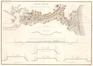
Early plan (1834) that indicates a route different from what was actually constructed.
-
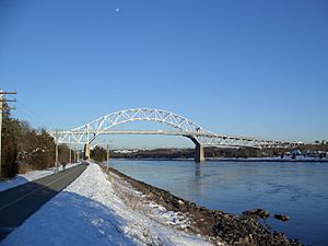
Bourne Bridge
-
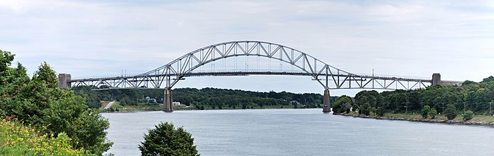
Sagamore Bridge
-
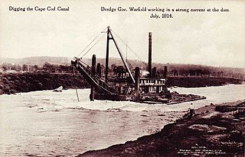
The Gov. Warfield digging the canal in 1914
-
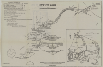
A 1922 map of the Cape Cod Canal, showing bridges, mooring points, and other features
,_1834_map.jpg)


