Biscayne Bay facts for kids
Quick facts for kids Biscayne Bay |
|
|---|---|
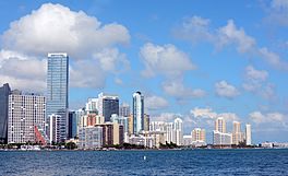
Northern Biscayne Bay with the Downtown Miami skyline in the background in November 2014
|
|
| Coordinates | 25°33′57″N 80°12′59″W / 25.56583°N 80.21639°W |
| Ocean/sea sources | Atlantic Ocean |
| Basin countries | United States |
| Max. length | 60 miles (97 km) |
| Max. width | 8 miles (13 km) |
| Surface area | 271 square miles (700 km2) |
| Settlements | Miami Miami Beach, Florida |
Biscayne Bay is a large, shallow body of water on the Atlantic coast of South Florida. It's like a mix between a lagoon (a shallow body of water separated from the ocean by a barrier) and an estuary (where fresh river water mixes with salty ocean water).
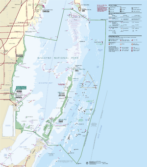
The northern part of Biscayne Bay is surrounded by the busy city of Miami. But the southern part is mostly natural and protected. A big piece of it is part of Biscayne National Park. The main part of the bay is about 35 miles (56 km) long and up to 8 miles (13 km) wide.
Contents
What's in a Name?
How did Biscayne Bay get its name?
The name "Biscayne Bay" comes from a sailor. In the 1500s, a sailor from the Bay of Biscay (a bay in Europe) was shipwrecked in Florida. His name was "Viscayno" or "Biscayno."
A map from the 1600s shows an island called Cayo de Biscainhos. This island is probably where Key Biscayne got its name. The bay was first called "Key Biscayne Bay" in the 1800s. Later, its name became shorter, just "Biscayne Bay."
Other Names for the Bay
Over time, the bay has had many names. In 1513, Juan Ponce de León called it Chequescha. Later, in 1565, Pedro Menéndez de Avilés called it Tequesta. These names are different ways to spell "Tequesta." The Tequesta people lived around the bay at that time.
When the British controlled Florida (from 1763 to 1783), they gave the bay new names. They called it "Cape River," "Dartmouth Sound," and "Sandwich gulph."
Exploring Biscayne Bay's Geography
Biscayne Bay is a subtropical lagoon. It stretches almost the entire length of Miami-Dade County. You can find it from North Miami Beach down to the upper Florida Keys.
The bay is bordered on the west by the Florida mainland. On the east, it's separated from the Atlantic Ocean by islands. These include barrier islands in the north and the northernmost of the Florida Keys in the south. The bay is about 35 miles (56 km) long and up to 8 miles (13 km) wide. Its average depth is about 6 feet (1.8 meters).
The Bay's Natural Foundation
The eastern edge of the bay sits on an old coral reef. This reef formed about 100,000 years ago. When sea levels dropped, the reef was left above water. It turned into fossilized rock, called Key Largo Limestone. This rock forms the base for the barrier islands and shoals (shallow areas) in the bay.
The western side of the bay acts like an estuary. Sixteen waterways flow into it, with the Miami River being the largest. These waterways have special structures to control the flow of salt water inland. They also manage how much fresh water enters the bay. Some fresh water also comes from underground, from the Biscayne Aquifer.
Scientists often divide Biscayne Bay into three main parts: North Bay, Central Bay, and South Bay.
North Bay: The Urban Heart
The North Bay is located between Miami Beach (on a barrier island) and Miami (on the mainland). It stretches from Dumfoundling Bay in the north to the Rickenbacker Causeway in the south. Many cities are along its shores, like Aventura, North Miami, and Miami Shores.
This part of the bay has been changed a lot by people. Many channels have been dug, and artificial islands have been created. More than 40% of North Bay's area has been dug up or filled in. This has created new land for buildings. The water in North Bay can be cloudy because of changes to the land.
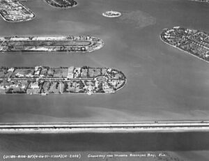
Several bridges, called causeways, cross North Bay. These include the Broad Causeway, John F. Kennedy (79th Street) Causeway, Julia Tuttle Causeway, Venetian Causeway, and MacArthur Causeway. Many islands in North Bay were made from material dug from the bay. Most of these islands, like the Venetian Islands, are now home to houses.
Central Bay: A Mix of City and Nature
Central Bay is the largest part of Biscayne Bay. It goes from the Rickenbacker Causeway in the north to the Featherbed Bank in the south. It's separated from the Atlantic Ocean by Key Biscayne and the Ragged Keys. Cities like Coral Gables and Palmetto Bay are on its western shore.
Fresh water flows into Central Bay from waterways like the Coral Gables Waterway. The Miami Seaquarium and the University of Miami's marine science school are located here. Central Bay has been affected by development and changes in fresh water flow.
South Bay: Mostly Natural and Protected
South Bay is almost as big as Central Bay. It stretches from the Featherbed Bank to the Arsenicker Keys. The northern Florida Keys, like Boca Chita Key and Elliott Key, separate it from the ocean.
South Bay is the least changed by human activities. However, it also suffers from less natural fresh water flow. The Turkey Point Nuclear Generating Station is located on the mainland shore of South Bay.
Card Sound and Barnes Sound
Card Sound and Barnes Sound are extensions of Biscayne Bay to the south. They are bordered on the east by Key Largo. These areas are connected to Florida Bay by small channels.
Manatee Bay is next to Barnes Sound. It's known for its untouched natural areas. The water here doesn't mix much with the open ocean. This means its saltiness can change a lot. In July 2023, the water temperature in Manatee Bay was recorded at a very high 101.1°F (38.4°C).
The Safety Valve: A Natural Protector
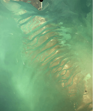
The Safety Valve is a series of shallow sand flats with channels for water to flow through. It stretches about 8 miles (13 km) from the south end of Key Biscayne to the Ragged Keys. This area helps control the effects of storm surges on the bay. It lets excess water flow out to the ocean during storms.
Stiltsville is a group of buildings built on stilts on some of these sand flats.
History of Biscayne Bay
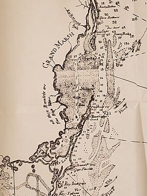
About 4,000 years ago, what is now Biscayne Bay was a freshwater area. As sea levels rose, ocean water flowed in, turning it into the estuary/lagoon we see today. Before the 1900s, most fresh water flowed away from the bay. But there were freshwater marshes and springs along the western shore.
People have lived in the Biscayne Bay area for a very long time. Bones and tools nearly 11,000 years old have been found nearby. When Europeans first arrived in the 1500s, the Tequesta people lived around the bay. Their main town, also called Tequesta, was at the mouth of the Miami River.
Spanish explorers like Juan Ponce de León visited Biscayne Bay in 1513. Pedro Menéndez de Avilés came in 1565.
In the 1800s, hurricanes created new inlets, like Narrows Cut (now Norris Cut). This separated Virginia Key from what is now Fisher Island. In 1905, Government Cut was dug, further changing the coastline. In 1925, Baker's Haulover Inlet was dredged. These changes allowed more ocean water into the bay, making it saltier.
Dredging for ship channels and the Intracoastal Waterway also created artificial islands in North Bay. By 1981, over 40% of North Bay had been dredged or filled to make new land. Most of the shoreline in North Bay is now lined with Seawalls.
Over the last century, the bay has been affected by pollution from cities. However, water quality has been getting better since monitoring began in 1979.
Causeways: Connecting the Bay
The first bridge across Biscayne Bay was the Collins Bridge. It was a 2.5-mile (4 km) wooden bridge built in 1912. This bridge helped turn Miami Beach into a popular resort. It was a toll bridge, meaning you had to pay to cross it.
In 1925, the Collins Bridge was taken down. A stronger bridge, the Venetian Causeway, replaced it the next year. This new causeway connected Miami to the Venetian Islands, which were artificial islands created in the bay.
The MacArthur Causeway opened in 1920. It was the second causeway to connect Miami to Miami Beach. Later, in 1959, the Julia Tuttle Causeway was built.
Other important causeways include the John F. Kennedy (79th Street) and Broad causeways. The Rickenbacker Causeway connects Miami to Key Biscayne. The Card Sound Bridge connects the mainland near Homestead, Florida to the northern part of Key Largo.
Parks and Marinas: Enjoying the Bay
A large part of Biscayne Bay is protected within Biscayne National Park. Many other state and local parks are also located along the bay's shores.
Bill Baggs Cape Florida State Park is on the southern part of Key Biscayne. Oleta River State Park is in the north, where the Oleta River meets the bay.
Miami-Dade County runs several parks along the bay. These include Haulover Park, Crandon Park (on Key Biscayne), Vizcaya Museum and Gardens, Matheson Hammock Park, and Black Point Park and Marina. Many of these parks have public marinas where boats can dock.
The City of Miami also has many parks along the bay. Some well-known ones are Bayfront Park, Margaret Pace Park, and Maurice A. Ferré Park. Public marinas in Miami include Dinner Key Marina and Miamarina at Bayside.
Protected Areas: Keeping the Bay Healthy
Most of Biscayne Bay that is not part of Biscayne National Park is protected as the Biscayne Bay Aquatic Preserve. This preserve was created in 1974 to protect the bay's waters and habitats. It includes about 69,000 acres (279 km²) of submerged land owned by the state.
Card Sound and Barnes Sound are part of the Florida Keys National Marine Sanctuary. This sanctuary helps protect the marine life and habitats in these areas.
The Crocodile Lake National Wildlife Refuge on Key Largo also includes some open water in Card Sound and Barnes Sound. Lobsters are protected all year in the Biscayne Bay-Card Sound Lobster Sanctuary. This sanctuary covers a large part of the bay.
In August 2020, there was a serious event in Biscayne Bay. The water lost too much oxygen, causing a fish kill. Many fish suffocated and floated to the surface. Fireboats were sent out to spray water into the air to add oxygen back into the bay.
Threats to the Bay
The sea level at Virginia Key has been rising steadily since 1931. This means the low-lying islands near the bay are at risk of more flooding in the future.
Human activities have also impacted the bay. Canals and quarries have changed the natural bedrock along the shores. Miami-Dade County operates a large landfill near Black Point, next to the bay.
There are also three wastewater treatment plants close to the bay. These plants clean water before it's released.
See also
 In Spanish: Bahía Vizcaína para niños
 | Dorothy Vaughan |
 | Charles Henry Turner |
 | Hildrus Poindexter |
 | Henry Cecil McBay |


