Elliott Key facts for kids

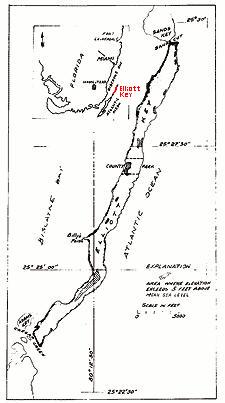
Sketch of Elliott Key
|
|
| Geography | |
|---|---|
| Location | Atlantic Ocean |
| Coordinates | 25°26′35″N 80°11′50″W / 25.44306°N 80.19722°W |
| Administration | |
| State | Florida |
| County | Miami-Dade |
Elliott Key is a special island in the Florida Keys. It is the largest island north of Key Largo. This island is part of the "true Florida Keys." This means it was formed from ancient coral reefs that rose above the ocean.
Elliott Key is located entirely within Biscayne National Park. You can find it in Miami-Dade County, Florida, east of Homestead, Florida. The Atlantic Ocean is to its east, and Biscayne Bay is to its west. To the north is Sands Key, and to the south is Old Rhodes Key. Adams Key is also nearby, just west of Elliott Key's southern end.
This island is about 7 miles (11 km) long. Its widest part is about 2,500 feet (760 m) near the north end. The island's average width is less than 2,000 feet (610 m). The highest spots on the island are about 6 to 8 feet (1.8 to 2.4 m) above sea level. These higher areas are usually found along a dirt road that runs through the middle of the island. The average height of the island is about 3 feet (0.9 m) above sea level.
You can only reach Elliott Key by boat. The island has a campground run by the National Park Service. Other than that, no one lives on Elliott Key.
Contents
Discovering Elliott Key's Past
Elliott Key has a long and interesting history. For thousands of years, Tequesta Indians visited the island. Later, fishermen also used it as a temporary home.
Early Names and Legends
The island was once called Ledbury Key. This name came from a ship called a "snow" that got stuck there in 1769. There are many exciting stories about Elliott Key. Some legends say that pirates used the island as a hiding place. One famous pirate, Black Caesar, is said to have used Elliott Key as his base. He was known for his daring adventures.
Pineapple Farming on the Island
In the late 1800s and early 1900s, people started living on Elliott Key. They grew lots of pineapples there. By 1910, more than a dozen families were farming pineapples. They would grow huge amounts, sometimes 50,000 to 75,000 dozen fruits! These pineapples were often sent by schooner (a type of sailing ship) all the way to New York.
Changes and Conservation Efforts
In the 1950s, there was a big plan for Elliott Key. Developers wanted to build a road and a causeway (a raised road over water) from Key Biscayne to Key Largo. This would have connected Elliott Key and other islands to the mainland.
The City of Islandia and Development Plans
Because of this plan, a new city was created called Islandia, Florida. This city included all the islands north of Key Largo. To get ready for the highway, developers cleared most of the land on Elliott Key. They also dug channels around it. This was done to stop the islands from becoming a park.
Protecting Elliott Key: Biscayne National Park
However, things changed when the Biscayne National Monument was created in 1968. The government bought much of the private land in the park. This stopped the highway project and further development on Elliott Key. The money meant for the causeway was used instead to build a new Card Sound Bridge. This bridge connects northern Key Largo to the mainland. The city of Islandia was eventually dissolved in 2012.
Hurricane Andrew's Impact
On August 24, 1992, a very strong storm hit Elliott Key. Hurricane Andrew made landfall directly on the island.
 | Ernest Everett Just |
 | Mary Jackson |
 | Emmett Chappelle |
 | Marie Maynard Daly |


