Key Largo facts for kids

Key Largo
|
|
| Geography | |
|---|---|
| Location | Gulf of Mexico |
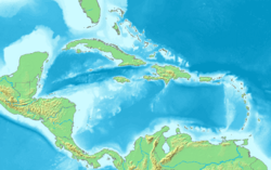
| Coordinates | 25°05′11″N 80°26′50″W / 25.0865°N 80.4473°W |
| Archipelago | Florida Keys |
| Adjacent bodies of water | Florida Straits |
| Administration | |
| State | Florida |
| County | Monroe |
Key Largo (which means "Long Cay" in Spanish) is a large island in the upper Florida Keys. It's the longest part of the Keys, stretching about 33 miles (53 kilometers). This island is one of the northernmost Keys in Monroe County. It is also the first Key you reach when driving south on U.S. Highway 1, also known as the Overseas Highway.
Key Largo is made up of three main areas: North Key Largo, Key Largo (the central part), and Tavernier (at the southern end). These areas had a combined population of 13,850 people in 2010. Key Largo is not a separate city; it is managed by Monroe County.
You can reach Key Largo from mainland Miami-Dade County by two main roads. The first is the Overseas Highway (U.S. Highway 1). The second is Card Sound Road, which connects to the northern part of Key Largo.
Key Largo is a very popular spot for visitors. It's often called the "Diving Capital of the World." This is because of the amazing living coral reefs located just a few miles offshore. These reefs attract thousands of scuba divers, sport-fishing fans, and scientists every year.
Because it's so close to the Everglades, Key Largo is also a great starting point for kayakers and people who enjoy ecotourism (traveling to natural areas). The Caribbean Club, a famous building, was built here in 1938 by Carl G. Fisher, a pioneer in cars and highways.
Key Largo is located between Everglades National Park to the northwest and John Pennekamp Coral Reef State Park to the east. John Pennekamp was the first underwater park in the United States! This state park helps protect part of the Florida Reef. This is the only living coral barrier reef in the continental United States. Barrier reefs are super important for coastal areas. They can block up to 97% of the strong ocean waves during hurricanes and other storms. This protects the land from flooding. The barrier reef itself provides over $675 million in protection from storm surge every year.
Contents
Exploring Key Largo's Past
When Europeans first arrived in the Florida Keys in the 1500s, the area was either empty or had very few native people, like the Calusa and Tequesta tribes. The first detailed description of the area came from Hernando de Escalante Fontaneda. He was shipwrecked and lived with the Calusa people from 1549 to 1566.
The name "Key Largo" first appeared on a map in 1639. A Dutch mapmaker named Johannes Vingboons called it Caio des 12 Leguas, which means "islet of twelve leagues." Later, Spanish explorers named it Cayo Largo, meaning "long islet."
In 1770, a Dutch surveyor named Bernard Romans said the area was empty. However, there was proof that native people visited the island sometimes. By 1858, after the Third Seminole War, the United States government controlled the area. But it still remained mostly empty. In 1870, the first post office opened in the area, called "Caya Largo."
The island became famous because of the 1948 film Key Largo. Even though the movie was mostly filmed in Hollywood, it made the island well-known. After the movie's success, local businesses wanted to change the name of the post office from "Rock Harbor" to "Key Largo." This happened on June 1, 1952. After that, everyone living north of Tavernier had a "Key Largo" address.
Understanding Key Largo's Land
Key Largo is actually an old, fossilized coral reef that was once underwater. Over time, the sea level changed, and the reef was uncovered and shaped by erosion. The highest point on the island is a small ridge that runs through its middle, rising to about 15 feet (4.6 meters).
The ground on Key Largo is made of something called Key Largo limestone. In many places, you can see fossilized corals and smooth, worn-down limestone on the surface. Rainwater, which is slightly acidic, has dissolved parts of the limestone, creating shallow holes called "solution holes."
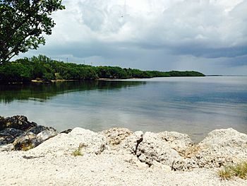
The natural edge of the island, where it meets the water, is usually rocky. The soil near the shore is a slippery, gray, limestone-based clay called "marl." You won't find natural sandy beaches on Key Largo. Inland, old plants that have broken down create a rich, dark soil. This soil helps many different plants, shrubs, and trees grow on the island.
Key Largo's Sunny Climate
Key Largo has a tropical savanna climate. This means it's usually warm and sunny all year round. It has never been cold enough for frost on the island! Key Largo enjoys almost 3,000 hours of sunshine each year, making it a very bright and pleasant place.
|
||||||||||||||||||||||||||||||||||||||||||||||||||||||||||||||||||||||||||||||||||||||||||||||||
See also
 In Spanish: Cayo Largo (isla) para niños
 | Leon Lynch |
 | Milton P. Webster |
 | Ferdinand Smith |


