
Key Biscayne facts for kids
.jpg)
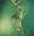
Aerial view of Key Biscayne in 1999
|
|

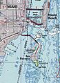
Map of Key Biscayne
|
|

Key Biscayne
Location in Florida

Key Biscayne
Location in the United States
|
|
| Geography | |
|---|---|
| Location | Miami-Dade County, Florida, U.S. |
| Coordinates | 25°41′25″N 80°09′54″W / 25.690329°N 80.165118°W |
| Length | 5 mi (8 km) |
| Width | 1.5 mi (2.4 km) |
| Highest elevation | 5 ft (1.5 m) |
| Administration | |
|
United States
|
|
Key Biscayne (Spanish: Cayo Vizcaíno) is a beautiful island in Miami-Dade County, Florida. It sits between the Atlantic Ocean and Biscayne Bay. This island is the most southern of the barrier islands along Florida's Atlantic coast. It is located south of Miami Beach and southeast of Miami. You can reach Key Biscayne from Miami by crossing the Rickenbacker Causeway, which was built in 1947.
The northern part of Key Biscayne is home to Crandon Park, a large county park. In the middle of the island, you'll find the small town called Key Biscayne Village. The southern tip of the island is protected as Bill Baggs Cape Florida State Park. This park is right next to Biscayne National Park, one of two national parks in Miami-Dade County.
Contents
Understanding Key Biscayne's Geography
Even though it's called a "key," Key Biscayne is not like the Florida Keys in how it was formed. Instead, it is a barrier island made of sand. This sand came from the Appalachian Mountains. Rivers carried the sand to the coast, and then ocean currents moved it south. There is no hard rock close to the surface of the island. Geologists believe the island formed around 2000 BCE. This happened when sea levels stopped rising, and sand built up to create new barrier islands.
Key Biscayne is long and narrow, stretching from north to south. It is about 5 miles (8 km) long and 1 to 2 miles (1.6 to 3.2 km) wide. At its northern end, a channel called Bear Cut separates it from another barrier island, Virginia Key. The southern end of the island is called Cape Florida. The Cape Florida Channel separates the island from the "Safety Valve." This area has shallow flats and tidal channels that go south for about 9 miles (14 km) to the Ragged Keys.
The Cape Florida Channel and Bear Cut were once the deepest natural ways for large ships to enter Biscayne Bay. This was before people started digging artificial channels in the early 1900s. In 1849, the island had a nice sandy beach on its east side. The west side had mangrove trees and lagoons. The island is very low, usually less than 5 feet (1.5 m) above sea level.
Key Biscayne is located at 25°41′25″N 80°9′54″W / 25.69028°N 80.16500°W (25.690329, -80.165118).
A Look at Key Biscayne's History
Early Inhabitants and European Arrivals
The first known people to live on Key Biscayne were the Tequesta tribe. Shells, bones, and artifacts found on the island show that the Tequesta used it a lot. A large community seemed to live there between 1,500 and 2,000 years ago. In 1992, Hurricane Andrew cleared away much of the plants on the southern end of Key Biscayne. An archaeological study of the exposed ground found many signs of past human life.
Juan Ponce de León explored Key Biscayne on his first trip to the New World in 1513. He named the island Santa Marta and claimed it for Spain. He said he found a fresh water spring on the island. Ponce de León called the bay behind the island (Biscayne Bay) Chequescha, which was another name for Tequesta.
The next European to visit the Key Biscayne area was Pedro Menéndez de Avilés in 1565. His ship found shelter in Biscayne Bay during a storm. They made friends with the Tequesta, and in 1567, a mission was set up on the mainland across the bay. This mission closed three years later.
A sailor from the Bay of Biscay, called the Viscayno or Biscayno, once lived on Florida's lower east coast after his ship was wrecked. A map from the 1600s shows Cayo de Biscainhos, which is likely where the name Key Biscayne comes from.
The first known European settlers on Key Biscayne were Pedro Fornells and his family. They were survivors from a colony in northern Florida. In 1805, Fornells received a special grant for 175 acres (0.7 km²) on the southern end of Key Biscayne. He had to live on the island and start farming within six months. His family moved there, but after six months, they went back to St. Augustine, leaving a caretaker named Vincent on the island.
Key Biscayne in the Territorial Years
Florida became a U.S. territory in 1821 after a war and a treaty with Spain. Seminole and Black Seminoles started moving into central and southern Florida. In the early 1800s, many African-American slaves and Black Seminoles escaped to the Bahamas from Cape Florida. Hundreds did so in the 1820s to avoid American slave owners.
Around 300 Black Seminoles found a way to Andros Island in the Bahamas from Key Biscayne. They used canoes and Bahamian boats. In 1820, someone saw 60 "Indians," 60 "runaway slaves," and 27 boats of Bahamian wreckers getting ready to leave Cape Florida.
In 1824, Mary Ann Channer Davis bought the Fornells' claim to Key Biscayne for US$100. Mary and her husband, William Davis, likely knew about plans to build a lighthouse on the Florida coast. They probably guessed Key Biscayne would be a good spot. Mary and William sold three acres (1.2 hectares) of their land at Cape Florida to the U.S. government for US$225. The government built the Cape Florida lighthouse there in 1825.
The first U.S. citizens to live permanently on Key Biscayne were Captain John Dubose, his wife Margaret, and their five children in 1825. Dubose became the first keeper of the new Cape Florida Light. He stayed until the lighthouse was burned in 1836. The Dubose family also had two former slaves with them. In 1835, a big hurricane hit the island. It damaged the lighthouse and the keeper's house. The island was covered in three feet of water.
War with the Seminoles and the Lighthouse Attack
In 1836, during the Second Seminole War, Seminole warriors attacked and burned the Cape Florida lighthouse. The assistant lighthouse keeper was badly hurt, and his Black assistant died from his wounds. The lighthouse was not fixed until 1847.
A military base was set up on Key Biscayne in March 1838. It was first called Fort Dallas or Fort Bankhead, but later renamed Fort Russell. This was in honor of Captain Samuel L. Russell, who was killed by Seminoles in 1839. In the summer of 1839, 143 soldiers and sailors were at Fort Russell. Some Seminoles captured during the war were held there before being moved to Indian Territory.
A hospital was also at Fort Russell for soldiers and sailors. In August 1840, the Army doctor treated 103 patients. Many had fever or dysentery. Dysentery was the main cause of death at the fort.
Colonel William S. Harney took over from Colonel Bankhead in 1839. Harney had faced Seminoles before. He started intense training for his men in swamp and jungle fighting. After Chief Chakaika raided Indian Key in August 1840, Harney went into the Everglades and killed Chakaika. The war became quieter after that.
While the war continued, Mary and William Davis planned to build a town on Key Biscayne. They even had a town map printed. The island was promoted as a great place "for the recovery of the health." In 1839, a post office was approved for Key Biscayne. The first two lots of the new town were sold to Lt. Col. Harney for US$1,000. However, the post office never opened, and no more town lots were sold.
The Davises hoped a fixed lighthouse would be the center of their town. But all attempts to repair it failed during the war. After the war, the Davises gave up on Key Biscayne and moved to Texas.
Lighthouse Repairs and Surveys
_01_rotate_and_crop.jpg)
Many ships were wrecked along Florida's southeast coast. This was a big problem. Between the late 1840s and late 1850s, over 500 ships were wrecked on the Florida Reef.
In 1846, the U.S. Congress gave US$23,000 to rebuild the Cape Florida lighthouse. It was finished in 1847.
In 1849, the United States Board of Engineers surveyed the Florida coast. They suggested that Key Biscayne become a military area, and the United States Secretary of War agreed. Later that year, the Army Corps of Topographical Engineers set up a camp there. They used it as a base for surveying the Florida Keys.
To learn more about the Great Florida Reef, Alexander Bache invited Louis Agassiz to study it. Agassiz went to Key Biscayne in 1851 and wrote a detailed report on the reefs.
The U.S. Coast Survey conducted a detailed survey with men from the U.S. Army and Navy. About forty men were based at Cape Florida in 1855, working on the survey.
In 1861, Confederate soldiers damaged the lighthouse. They wanted to stop it from guiding Union ships during the blockade of Florida. The lighthouse was fixed and lit again in 1866. In 1878, the Cape Florida Light was replaced by the Fowey Rocks Light, which was seven miles (11 km) southeast of Cape Florida.
From 1888 to 1893, the Cape Florida lighthouse was rented to the Biscayne Bay Yacht Club for US$1.00 per year. It was their headquarters. It was known as the southernmost yacht club in the U.S. and the tallest in the world.
In 1898, during the Spanish–American War, the Cape Florida lighthouse became U.S. Signal Station Number Four. It was one of 36 stations along the U.S. East and Gulf Coasts. These stations gave early warnings if the Spanish fleet approached.
Developing Key Biscayne
Key Biscayne was first developed for growing coconuts. There were mature coconut trees on Cape Florida by the 1830s. These likely grew from coconuts sent from Mexico by Henry Perrine to the first lighthouse keeper, John Dubose.
In the 1880s, Ezra Asher Osborn and Elnathan T. Field started a plan to develop the Florida coast. They cleared plants and planted coconuts. They brought 300,000 coconuts from the Caribbean. Of these, 76,000 were planted on Key Biscayne. However, rats and rabbits ate most of the young coconut shoots. In 1885, Osborn and Field were allowed to buy Key Biscayne and other land for 70 cents an acre.
Waters Smith Davis, the son of Mary Ann Davis, started to claim his family's ownership of the island. In 1903, Davis bought the abandoned Cape Florida lighthouse from the U.S. Treasury for US$400.
Davis started a pineapple farm on Key Biscayne. By 1898, many different tropical fruit trees were planted on the island. Davis also built a large, two-story house for himself.
In the late 1890s, Davis hired Ralph Munroe to manage his Key Biscayne property. Munroe was involved in wrecking (salvaging shipwrecks) around Key Biscayne. He also built sailboats and worked as a pilot for the Cape Florida Channel. He opened a pineapple cannery where Davis sent his pineapples.
In 1896, Henry Morrison Flagler brought the Florida East Coast Railway to Miami. The Davises had dreamed of building a city on Key Biscayne. But Waters Davis, now a rich man, only wanted to keep Key Biscayne as a quiet place for his family.
Coconut Plantation and Resort Dreams

In 1902, William John Matheson, who made his money in dyes, visited Biscayne Bay. In 1908, Matheson started buying land on Key Biscayne north of the Davis property. He bought over 1,700 acres (690 hectares). Matheson created a large plantation community. It had homes for workers, packing houses, docks, a school, and 15 miles (24 km) of roads. The plantation had 36,000 coconut trees and other tropical fruits. In 1921, Matheson brought the Malay Dwarf coconut to the U.S. This is now the most common coconut in Florida. By 1933, the price of coconut products dropped, and the plantation stopped shipping.
Waters Davis decided to sell his Key Biscayne property in 1913. Ralph Munroe helped him sell it for US$20,000 to James Deering. Deering was an heir to the International Harvester company. In 1914, Deering decided to develop his new land on the island as a tropical resort. He believed Cape Florida's "future lies in making sales for homes." To prepare, the land was cleared, and wet areas were filled in.
Waters Davis said in his sale to Deering that the Cape Florida lighthouse must be restored. Deering asked the U.S. government for details. Government officials were surprised, wondering how a federal lighthouse could be privately owned. After much legal work, the U.S. Congress and President Woodrow Wilson agreed to recognize Matheson's and Deering's ownership of Key Biscayne.
In 1920, the heirs of Venancio Sanchez sued James Deering. This stopped the resort development on Cape Florida. After many legal battles, the United States Supreme Court decided in Deering's favor in 1926. But it was too late for Deering, as he had died the year before.
From the 1920s to the 1950s


In February 1926, William Matheson agreed with D. P. Davis, a land developer, to develop the northern half of Key Biscayne. This included what is now Crandon Park and part of the Village of Key Biscayne. Davis was good at turning wet land into valuable property. Later in 1926, the City of Coral Gables included Key Biscayne within its borders. There were dreams of a bridge to the island, making Key Biscayne a seaside resort for Coral Gables.
But problems arose. In March 1926, the U.S. government auctioned off some lots on Key Biscayne. The Mathesons wanted clear ownership of all their land. They paid US$58,055 for 6.84 acres (2.77 hectares) of land. This was a record price per acre for U.S. government land at that time. On September 18, 1926, the Great Miami Hurricane hit Key Biscayne. Most buildings were destroyed or badly damaged. Many plants were lost, including half of the coconut trees. D. P. Davis could not finish his contract and went bankrupt.
The Florida land boom ended, and no bridge was built. No development happened on Key Biscayne for the next twenty years. William Matheson died in 1930, leaving the island to his children.
In 1940, William Matheson's children gave 808.8 acres (327.3 hectares) of land on the northern end of Key Biscayne to Dade County. This land, which included 2 miles (3.2 km) of beach, was to be a public park. It was later named Crandon Park. The county commissioner, Charles H. Crandon, had offered to build a causeway to Key Biscayne in exchange for the land. Construction on a causeway to Virginia Key started in 1941.
The Attack on Pearl Harbor and the start of World War II stopped all work on the causeway. After the war, Crandon continued the project. He got Ed Ball to buy US$6 million worth of bonds to fund the causeway. The causeway was named for Eddie Rickenbacker, a World War I flying ace.
Starting in 1951, the Mackle Construction Company offered new homes on the island for US$9,540, with a US$500 down payment. A U.S. Post Office branch opened, a Community Church started services, and the Key Biscayne Elementary School opened in 1952.
Cape Florida Becomes a State Park

In 1948, José Manuel Áleman, who had left Cuba, bought the Cape Florida property from the Deering estate. His offer to donate the lighthouse and ten acres (4 hectares) of land around it to the National Park Service was not accepted.
In 1950, the Dade County Planning Board announced a plan to build a highway connecting Key Biscayne with the Overseas Highway on Key Largo. This plan involved bridges connecting artificial islands to Elliott Key and then to Key Largo. Áleman was expected to donate land for a road through the middle of the island to the first bridge at Cape Florida. With a major highway possibly coming through his land, Áleman quickly prepared it for development. He had it cleared, leveled, and filled in. A seawall was built along the western side of the Cape Florida property.
Áleman died in 1951, and the County soon dropped its road plan. His widow, Elena Santeiro Garcia, bought more land at Cape Florida. This land included a canal dug by William Matheson in the 1920s. The land north of the canal became part of the present-day Village of Key Biscayne. Garcia sold the Cape Florida property in 1957 for US$9.5 million. Development started on a model community of luxury homes. By 1962, the new developers had money problems, and the property went back to Garcia in 1963.
Dade County started thinking about buying 50 acres (20 hectares) around the Cape Florida lighthouse for a park in 1964. Bill Baggs, editor of The Miami News, campaigned for all the Cape Florida property to be saved as a park. U.S. Interior Secretary Stewart Udall looked at the property and suggested it be saved.
In 1966, Baggs helped make a deal between Elena Santeiro Garcia and the state of Florida. Florida bought the property for US$8.5 million. US$2.3 million of this came from the U.S. government. This land was named the Bill Baggs Cape Florida State Park, and it opened on January 1, 1967. In 2004, a sign was put up to remember the site as part of the National Underground Railroad Network to Freedom Trail. This honors the Black Seminoles who escaped to the Bahamas from here.
Images for kids
-
Aerial view of Key Biscayne in 1999
-
Map of Key Biscayne
-
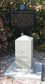
U.S. Coast Survey Base Marker
-
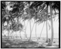
Biscayne Bay visible through coconut trees between 1900 and 1915
-
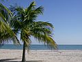
The beach at Crandon Park in Key Biscayne in February 2008
-
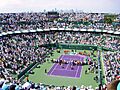
The Miami Open tennis tournament was held at Crandon Park in Key Biscayne from 1987 until 2019 when it moved to Hard Rock Stadium in Miami Gardens.
-
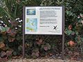
National Network to Freedom Trail sign commemorating hundreds of Black Seminoles who escaped from Cape Florida in the early 1820s to the Bahamas
See also
 In Spanish: Cayo Vizcaíno para niños
