Cape May Canal facts for kids
Quick facts for kids Cape May Canal |
|
|---|---|

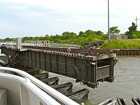
Railroad swing bridge, one of three bridges across the canal
|
|
| History | |
| Original owner | United States Army Corps of Engineers |
| Date of first use | 1942 |
| Geography | |
| Start point | Cape May Harbor |
| End point | Delaware Bay |
The Cape May Canal is a special waterway in New Jersey. It is about 3.3 miles (5.4 kilometers) long. This canal connects Cape May Harbor to the Delaware Bay. It is located at the very southern tip of Cape May County.
People had thought about building a canal here for a long time. But it was finally built during World War II. The United States Army Corps of Engineers created it. The main reason was to protect ships from German submarines, called U-boats. These U-boats were active near Cape May Point. The canal also became an important part of the Intracoastal Waterway. This is a protected water route along the coast. It helped ships travel safely without being attacked by enemy submarines. The canal was dug quickly in 1942 because it was an emergency during the war.
Contents
Building the Cape May Canal
Early Ideas for a Waterway
The idea for canals along the coast is very old. In 1808, Albert Gallatin suggested building canals. He was the Secretary of the Treasury at the time. His idea was to create an inland passage for ships. This passage would stretch from Massachusetts all the way south to North Carolina.
Later, in the 1840s, Nathaniel Holmes also suggested a canal across Cape May. Some people even started digging one. But these early plans did not fully happen.
Why the Canal Was Needed
More serious plans for the canal began after 1905. At that time, Cape May Sound was dredged. This means it was dug deeper to become part of the Intracoastal Waterway. Later, Cape May Harbor was also created by dredging. Cold Spring Inlet was also deepened. This made it easier for larger ships to enter the harbor.
The Navy built a base on Cape May Harbor in 1917. This showed how important these waterways were. Today, this base is a Coast Guard facility. It is called the United States Coast Guard Training Center Cape May.
Funding and Construction During World War II
The first bill in Congress to build the canal was in 1935. But it did not pass. Another bill passed in 1940. However, President Franklin D. Roosevelt did not sign it into law.
In November 1941, a new bill was signed. This bill allowed the canal to be built. But it did not provide money for it. Then, in early 1942, several ships were sunk by German U-boats. This made the need for the canal very clear. After this, both federal and state money became available. The canal was then built quickly.
How the Canal Changed the Land
The building of the Cape May Canal created a new "island." This island is called Cape Island. It includes the towns of Cape May, Cape May Point, and West Cape May. It also includes parts of Lower Township.
The canal, along with Cape Island Creek and Cape May Harbor, separates this island from the mainland. It cuts off Cape Island from the rest of the Cape May peninsula.
Crossing the Canal
There are three bridges that cross the Cape May Canal.
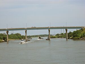
- One bridge is for Route 109. This road connects the Garden State Parkway to Cape May.
- Another bridge is for Route 162. This road is also known as Seashore Road. It leads into West Cape May.
- The third bridge is a railroad swing bridge. It is used by the Cape May Seashore Lines. A swing bridge can open to let boats pass through.
Today, many people use the canal for fun. It is very popular with recreational boats during the summer months.
 | Laphonza Butler |
 | Daisy Bates |
 | Elizabeth Piper Ensley |


