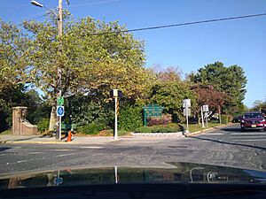
West Cape May, New Jersey facts for kids
Quick facts for kids
West Cape May, New Jersey
|
||
|---|---|---|
|
Borough
|
||
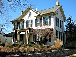
Whilldin-Miller House
|
||
|
||
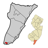
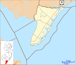
Location of West Cape May in Cape May County highlighted in red (left). Inset map: Location of Cape May County in New Jersey highlighted in orange (right).
|
||
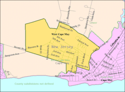
Census Bureau map of West Cape May, New Jersey
|
||
| Country | ||
| State | ||
| County | ||
| Incorporated | April 17, 1884 | |
| Named for | Cape May / Cornelius Jacobsen May | |
| Government | ||
| • Type | Walsh Act | |
| • Body | Board of Commissioners | |
| Area | ||
| • Total | 1.19 sq mi (3.07 km2) | |
| • Land | 1.17 sq mi (3.04 km2) | |
| • Water | 0.01 sq mi (0.03 km2) 1.09% | |
| Area rank | 489th of 565 in state 14th of 16 in county |
|
| Elevation | 10 ft (3 m) | |
| Population
(2020)
|
||
| • Total | 1,010 | |
| • Estimate
(2023)
|
1,003 | |
| • Rank | 530th of 565 in state 13th of 16 in county |
|
| • Density | 860.8/sq mi (332.4/km2) | |
| • Density rank | 400th of 565 in state 9th of 16 in county |
|
| Time zone | UTC−05:00 (Eastern (EST)) | |
| • Summer (DST) | UTC−04:00 (Eastern (EDT)) | |
| ZIP Code |
08204
|
|
| Area code(s) | 609 | |
| FIPS code | 3400978530 | |
| GNIS feature ID | 0885435 | |
West Cape May is a small town, called a borough, located in Cape May County, New Jersey. It is part of the South Jersey region. The town is also near the larger Philadelphia area. In 2020, about 1,010 people lived there.
The borough was officially formed on April 17, 1884. It was created from parts of Lower Township. The name "Cape May" comes from a Dutch captain named Cornelius Jacobsen May. He explored and mapped the area between 1611 and 1614.
In October 2012, during Hurricane Sandy, West Cape May received a lot of rain. It had about 9.53 inches, which was the most in New Jersey. For many years, West Cape May was a "dry town," meaning alcohol could not be sold. This changed in May 2012 when a new store opened.
Contents
History of West Cape May
The history of West Cape May goes back to the Lenape Native Americans. Some buildings in the town are very old, from the Colonial period. The area has a rich history of farming. This is still celebrated today with a summer farmers' market. There are also festivals for strawberries, tomatoes, and lima beans. West Cape May is even known as the "Lima Bean Capital of the World." The Lima Bean Festival happens every year in October at Wilbraham Park.
West Cape May was once called Eldredge. It is one of four areas that make up Cape Island in Cape May County. The borough was officially created by the New Jersey Legislature on April 17, 1884. This happened after people voted for it two days earlier. The borough was re-established in 1890 and again in 1897.
The town also has connections to the Underground Railroad. This was a secret network that helped enslaved people find freedom.
From 1881 to 1931, the Hastings Goldbeating Company was in West Cape May. Women worked there, pounding gold into very thin sheets for art. This business, along with land sales, helped the borough become officially recognized in 1884. You can find a plaque about the factory on Goldbeaten Alley.
Historic Places to Visit
The old part of West Cape May was added to the National Register of Historic Places in 1976. This list includes important historical sites.
The Whilldin-Miller House was added to this list in 2003. The oldest part of the house was built around 1715 by Joseph Whilldin. The front part was added in 1860. This makes it one of the oldest houses on Cape Island.
Geography and Location
West Cape May covers about 1.19 square miles (3.07 square kilometers). Most of this is land, with a small amount of water.
The borough shares its borders with two other towns in Cape May County. These are Cape May City and Lower Township.
Population and People
| Historical population | |||
|---|---|---|---|
| Census | Pop. | %± | |
| 1890 | 757 | — | |
| 1900 | 696 | −8.1% | |
| 1910 | 844 | 21.3% | |
| 1920 | 967 | 14.6% | |
| 1930 | 1,048 | 8.4% | |
| 1940 | 934 | −10.9% | |
| 1950 | 897 | −4.0% | |
| 1960 | 1,030 | 14.8% | |
| 1970 | 1,005 | −2.4% | |
| 1980 | 1,091 | 8.6% | |
| 1990 | 1,026 | −6.0% | |
| 2000 | 1,095 | 6.7% | |
| 2010 | 1,024 | −6.5% | |
| 2020 | 1,010 | −1.4% | |
| 2023 (est.) | 1,003 | −2.1% | |
| Population sources: 1890–2000 1890–1920 1890 1890–1910 1910–1930 1940–2000 2000 2010 2020 |
|||
How Many People Live Here?
In 2010, there were 1,024 people living in West Cape May. Most residents were White (85.84%). About 8.69% were Black or African American. A small number were Native American, Asian, or from other backgrounds. About 4.98% of the population was Hispanic or Latino.
The average age of people in West Cape May was 55 years old. About 12.8% of the population was under 18. Many residents were between 45 and 64 years old (39.2%).
African-American Community
African-Americans have lived in West Cape May since the early 1800s. There is a West Cape May African-American Historical Society. The community was once very active. By 2020, about 5% of the population was African-American.
How West Cape May is Governed
West Cape May uses a special type of government called the Walsh Act. This means the town is run by a Board of Commissioners. There are three members on this board. They are elected by the public in November and serve for four years.
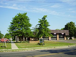
Once elected, the Commissioners share the responsibility for different town departments. Each Commissioner leads a department. As of 2024, the Commissioners are Mayor Carol E. Sabo, Deputy Mayor George Dick, and Giacomo "Jack" Antonicello. Their terms end on December 31, 2025.
Voting and Politics
In West Cape May, people tend to vote for the Democratic Party in presidential elections. For example, in the 2020 election, the Democratic candidate received 61.1% of the votes. In the 2024 election, the Democratic candidate received 58.3% of the votes.
| Year | Republican | Democratic |
|---|---|---|
| 2024 | 40.0% 283 | 58.3% 413 |
| 2020 | 37.9% 276 | 61.1% 445 |
| 2016 | 38.0% 234 | 57.6% 354 |
| 2012 | 37.2% 235 | 61.0% 385 |
| 2008 | 35.0% 215 | 62.9% 387 |
| 2004 | 38.5% 240 | 60.5% 377 |
Education in West Cape May
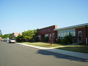
The West Cape May School District serves students from pre-kindergarten through sixth grade. These students attend West Cape May Elementary School. In the 2023–24 school year, there were 85 students and about 9.7 teachers. This means there were about 8.8 students for every teacher.
For grades seven through twelve, students go to schools in the Lower Cape May Regional School District. This district also serves students from Cape May and Lower Township. The schools are Richard M. Teitelman Middle School (grades 7-8) and Lower Cape May Regional High School (grades 9-12).
Students can also choose to attend Cape May County Technical High School. This school offers both regular and vocational programs for students across the county.
School History
In the past, West Cape May had its own high school. During a time when schools were separated by race, only white students usually attended. Black students went to a different industrial high school. The district also had separate elementary schools for white and black students.
Getting Around West Cape May
Roads and Highways
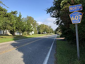
As of 2010, West Cape May had about 11.87 miles of roads. Most of these roads are maintained by the town itself. There are no major highways like Interstates or U.S. Routes directly in West Cape May. The most important roads are smaller county routes, such as County Route 607.
Public Transportation
NJ Transit provides bus service in the area. You can take the 552 bus route between Cape May and Atlantic City.
Parks and Fun Activities
Wilbraham Park is a popular spot in West Cape May. Every October, the famous lima bean festival is held there. The West Cape May Business Association also sponsors a strawberry festival in the town.
Wineries
See also
 In Spanish: West Cape May para niños
 | Aurelia Browder |
 | Nannie Helen Burroughs |
 | Michelle Alexander |


