
Cape May, New Jersey facts for kids
Quick facts for kids
Cape May, New Jersey
|
|||
|---|---|---|---|
|
City
|
|||

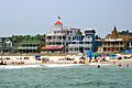
Beach Avenue in Cape May seen from the sea
|
|||
|
|||
| Motto(s):
The Nation's Oldest Seashore Resort
|
|||

Location of Cape May in Cape May County highlighted in red (left). Inset map: Location of Cape May County in New Jersey highlighted in orange (right).
|
|||

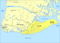
Census Bureau map of Cape May, New Jersey
|
|||

Cape May, New Jersey
Location in Cape May County, New Jersey

Cape May, New Jersey
Location in New Jersey

Cape May, New Jersey
Location in the United States
|
|||
| Country | |||
| State | |||
| County | Cape May | ||
| Incorporated | March 8, 1848, as Cape Island Borough | ||
| Reincorporated | March 10, 1851, as Cape Island City | ||
| Reincorporated | March 9, 1869, as Cape May City | ||
| Named for | Cornelius Jacobsen Mey | ||
| Government | |||
| • Type | Faulkner Act (council–manager) | ||
| • Body | City Council | ||
| Area | |||
| • Total | 2.90 sq mi (7.50 km2) | ||
| • Land | 2.47 sq mi (6.41 km2) | ||
| • Water | 0.42 sq mi (1.10 km2) 14.59% | ||
| Area rank | 341st of 565 in state 8th of 16 in county |
||
| Elevation | 10 ft (3 m) | ||
| Population
(2020)
|
|||
| • Total | 2,768 | ||
| • Estimate
(2023)
|
2,757 | ||
| • Rank | 457th of 565 in state 9th of 16 in county |
||
| • Density | 1,119.2/sq mi (432.1/km2) | ||
| • Density rank | 370th of 565 in state 6th of 16 in county |
||
| Time zone | UTC−05:00 (Eastern (EST)) | ||
| • Summer (DST) | UTC−04:00 (Eastern (EDT)) | ||
| ZIP Code |
08204
|
||
| Area code(s) | 609 | ||
| FIPS code | 3400910270 | ||
| GNIS feature ID | 0885178 | ||


Cape May is a city and popular seaside resort in New Jersey. It's located at the very southern tip of the Cape May Peninsula. This city is known as one of the oldest vacation spots in the United States.
Cape May is right on the Atlantic Ocean, close to where the Delaware Bay meets the sea. It's the southernmost city in New Jersey. In 2020, about 2,768 people lived there. However, in the summer, the population can grow to 40,000 or even 50,000 visitors!
The entire city of Cape May is a special place called the Cape May Historic District. It's a National Historic Landmark because it has so many beautiful Victorian buildings. In 2008, the Travel Channel even named Cape May one of the top 10 beaches in the U.S.
Contents
History of Cape May
Early Days and First Visitors
The land where Cape May now stands was first home to the Kechemeche Native American tribe. They were part of the larger Lenape tribe. Europeans first met them around the year 1600.
The city gets its name from a Dutch captain, Cornelius Jacobsen Mey. He explored and mapped the area between 1611 and 1614. Later, people from the New Haven Colony in New England settled here.
Cape May started welcoming vacationers from Philadelphia in the mid-1700s. This makes it the oldest seaside resort in the country.
Growth and Challenges in the 1800s
After the Congress Hall hotel was built in 1816, Cape May became even more popular. By the 1900s, it was seen as one of America's best resorts.
Cape May officially became a borough called Cape Island in 1848. It was later renamed Cape May City in 1869. Travel to the city became easier in 1863 when the Tuckahoe and Cape May Railroad opened.
The city faced big challenges with fires in 1869 and 1878. The 1878 fire destroyed 30 blocks of the town center. But the people rebuilt, mostly with Victorian-style homes. Today, Cape May has the second-largest collection of well-preserved Victorian houses in the nation, after San Francisco.
Cape May in the 20th Century
During World War II, many United States Navy facilities were set up in Cape May. This was to protect American ships from submarines off the coast. These facilities helped a lot in keeping ships and sailors safe.
In 1976, Cape May was named a National Historic Landmark. This means the entire city is a national historic district. This special title helps make sure its amazing old buildings are protected.
Geography and Climate


Cape May covers about 2.90 square miles (7.50 square kilometers). Most of this is land, with a smaller part being water. The city is quite flat, with its highest point only about 14 feet (4.3 meters) above sea level.
Cape May is bordered by Lower Township and West Cape May Borough. The Cape May–Lewes Ferry connects Cape May to Lewes, Delaware, across the Delaware Bay.
Cape May Harbor is a large harbor covering 500 acres. It was created by dredging, which finished in 1911. The harbor allows fishing boats to enter from the Atlantic Ocean.
Cape May is the southernmost point in New Jersey. It's about the same distance from Manhattan as it is from Virginia Beach.
Weather in Cape May
Cape May has a humid subtropical climate. This means it has hot, humid summers and cool winters. It rains throughout the year.
In summer, a cool sea breeze often blows in the afternoon. But sometimes, it can get very hot and humid. In winter, it can get very cold and windy. The average snowfall is about 15 inches (38 cm) per year. February is usually the snowiest month.
The ocean water temperature around Cape May changes with the seasons. It's coldest in February (around 40°F or 4°C) and warmest in August (around 76°F or 24°C).
What Cape May Offers


Tourism is the biggest industry in Cape May. The Washington Street Mall is a popular spot with shops, restaurants, and places to stay. Many historic hotels and B&Bs are found here. Fishing, both for fun and for business, is also important to the economy.
Cove Beach, at the very tip of Cape May, is a favorite spot for swimming, sunbathing, and surfing in the summer. Cape May is also a popular place for French Canadian tourists.
Arts and Culture


Cape May is famous for its beautiful Victorian homes. It also has a lively arts scene. The town hosts the Cape May Jazz Festival, Music Festival, and Film Festival.
The Mid-Atlantic Center for the Arts & Humanities (MAC) helps preserve Cape May's history. They saved the 1879 Emlen Physick Estate from being torn down. MAC offers tours and events at the Physick Estate, the Cape May Lighthouse, and the World War II Lookout Tower.
The Center for Community Arts (CCA) offers tours about African American history in Cape May. They are also turning the historic Franklin Street School into a cultural center. This school was built in 1928 for African-American students during a time of segregation.
Cape May Diamonds and Bird Watching
You can find "Cape May diamonds" at Sunset Beach and other local beaches. These are clear quartz pebbles that wash down from the Delaware River. Collecting them is a fun activity for visitors.
Cape May is also a world-famous spot for watching migrating birds. Over 400 different bird species have been seen here! Many bird watchers visit, especially in the fall. The Cape May Warbler, a small songbird, is named after this area. The Cape May Bird Observatory is located nearby.
You can also go on boat trips to see whales and dolphins in the waters near Cape May. This is because the mix of fresh and saltwater creates a rich environment for marine life.
Fisherman's Memorial
The Cape May Fisherman's Memorial honors local fishermen who have died at sea. It was built in 1988 and has a statue of a mother and children looking out to the harbor. A monument lists the names of 75 fishermen, starting from 1893. Visitors often leave a stone or seashell at the base of the statue to show their respect.
Education

_02.jpg)

Students in Cape May attend the Cape May City Elementary School for pre-kindergarten through sixth grade. Students from Cape May Point also attend this school. Many students come from the United States Coast Guard Training Center Cape May.
For seventh through twelfth grades, students go to schools in the Lower Cape May Regional School District. This district serves students from Cape May City, Cape May Point, Lower Township, and West Cape May. The schools are Richard M. Teitelman Middle School (grades 7-8) and Lower Cape May Regional High School (grades 9-12).
Students can also attend Cape May County Technical High School. This school offers both regular and vocational programs for students from across the county.
The nearest private Catholic school is Wildwood Catholic Academy in North Wildwood.
The Cape May Branch of the Cape May County Public Library is located in the city. In 2024, the library moved to the renovated Franklin Street School building.
History of Schools in Cape May
In the past, Cape May had schools that were separated by race. From 1928 to 1948, Black elementary school students attended the Franklin Street School. Cape May High School, however, educated students of all races.
The first Cape May High School was built in 1901. A new high school was built in 1917, and the old one became an elementary school. Cape May High School closed in 1960 when the new Lower Cape May Regional High School opened. The second Cape May High School building is now the city hall and police station.
Cape May also had its own Catholic school, Our Lady Star of the Sea School. This school later merged with others to form Wildwood Catholic Academy.
Transportation
_between_Sidney_Avenue_and_Cape_May_County_Route_622_(Texas_Avenue)_in_Cape_May,_Cape_May_County,_New_Jersey.jpg)
Cape May has about 31.63 miles (50.90 km) of roads. Route 109 leads into Cape May from the north. It connects to the southern end of the Garden State Parkway and U.S. Route 9.
Buses and Trains


NJ Transit provides bus service from Cape May to Philadelphia and Atlantic City. There is also seasonal bus service to Midtown Manhattan.
The Great American Trolley Company runs trolley tours in Cape May during the summer.
You can also take an excursion train ride from the Cape May City Rail Terminal. Regular passenger train service to Cape May ended in the 1960s.
Ferry Service
The Delaware River and Bay Authority operates the Cape May-Lewes Ferry all year round. This ferry takes passengers and cars across the Delaware Bay to Lewes, Delaware. The trip takes about 70-85 minutes.
Media

Cape May has several local media outlets. These include WCFA-LP 101.5 FM, a radio station that plays jazz and community programs. There are also weekly newspapers like the Cape May Star and Wave, The Cape May Gazette, and Exit Zero. Local websites like CapeMay.com and Cape May Times also share news.
The name "Exit Zero" refers to Cape May's location at the very end of the Garden State Parkway. Sometimes, the whole town is informally called Exit Zero.
Coast Guard Training Center Cape May

The United States Coast Guard Training Center Cape May is the only place where new Coast Guard recruits are trained in the entire nation. The U.S. Coast Guard took over the base in 1924. During the time of Prohibition, Coast Guard ships here helped stop illegal alcohol smuggling.
During World War II, a larger airstrip was built. The United States Navy used it to train aircraft carrier pilots. The Coast Guard also increased its presence for coastal patrols and rescue missions. In 1946, the Navy gave the base to the Coast Guard.
Since 1982, all Coast Guard recruit training has been done in Cape May. Over 350 military and civilian staff work at the Training Center.
Notable People
Many interesting people have connections to Cape May. Here are a few:
- Frederick B. Dent: A politician who served as the U.S. Secretary of Commerce.
- Eugene Grace: He was the president of Bethlehem Steel Corporation for many years.
- T. Millet Hand: A politician who served in the U.S. House of Representatives and was also the mayor of Cape May.
- Thomas H. Hughes: He founded and owned the famous Congress Hall Hotel.
- Jarena Lee: She was the first woman allowed to preach by the founder of the African Methodist Episcopal Church.
- Bill Pilczuk: A competitive swimmer.
- Louis Purnell: A curator at the National Air and Space Museum and a decorated Tuskegee Airman during WWII.
- Charles W. Sandman Jr.: A politician who ran for Governor of New Jersey.
- Witmer Stone: An ornithologist (bird expert) who did much of his research in Cape May.
- Harriet Tubman: A famous abolitionist and social activist. She helped many enslaved people escape to freedom. There is a museum in Cape May honoring her.
- Paul Volcker: A former chairman of the United States Federal Reserve. He was born in Cape May.
Images for kids
-
Beach Avenue in Cape May seen from the sea
-

Flag of Cape May, New Jersey
-
Seal of Cape May, New Jersey
-
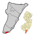
Location of Cape May in Cape May County
-
Census Bureau map of Cape May, New Jersey
| Climate data for Cape May 2 NW, New Jersey, 1991–2020 normals, extremes 1894–present | |||||||||||||
|---|---|---|---|---|---|---|---|---|---|---|---|---|---|
| Month | Jan | Feb | Mar | Apr | May | Jun | Jul | Aug | Sep | Oct | Nov | Dec | Year |
| Record high °F (°C) | 73 (23) |
75 (24) |
82 (28) |
91 (33) |
95 (35) |
99 (37) |
102 (39) |
99 (37) |
96 (36) |
96 (36) |
83 (28) |
76 (24) |
102 (39) |
| Mean maximum °F (°C) | 61.1 (16.2) |
62.7 (17.1) |
70.8 (21.6) |
80.8 (27.1) |
87.0 (30.6) |
92.3 (33.5) |
94.9 (34.9) |
93.0 (33.9) |
88.7 (31.5) |
81.8 (27.7) |
71.2 (21.8) |
63.6 (17.6) |
96.2 (35.7) |
| Mean daily maximum °F (°C) | 43.3 (6.3) |
45.2 (7.3) |
51.7 (10.9) |
61.8 (16.6) |
71.1 (21.7) |
80.1 (26.7) |
85.5 (29.7) |
84.3 (29.1) |
78.6 (25.9) |
67.9 (19.9) |
56.9 (13.8) |
48.1 (8.9) |
64.5 (18.1) |
| Daily mean °F (°C) | 35.9 (2.2) |
37.3 (2.9) |
43.6 (6.4) |
52.9 (11.6) |
62.3 (16.8) |
71.6 (22.0) |
76.9 (24.9) |
75.7 (24.3) |
70.1 (21.2) |
59.3 (15.2) |
48.8 (9.3) |
40.6 (4.8) |
56.2 (13.4) |
| Mean daily minimum °F (°C) | 28.5 (−1.9) |
29.4 (−1.4) |
35.4 (1.9) |
44.1 (6.7) |
53.5 (11.9) |
63.0 (17.2) |
68.3 (20.2) |
67.2 (19.6) |
61.7 (16.5) |
50.7 (10.4) |
40.6 (4.8) |
33.0 (0.6) |
47.9 (8.8) |
| Mean minimum °F (°C) | 13.1 (−10.5) |
15.5 (−9.2) |
21.2 (−6.0) |
32.2 (0.1) |
40.7 (4.8) |
51.1 (10.6) |
59.3 (15.2) |
57.2 (14.0) |
48.0 (8.9) |
35.7 (2.1) |
25.9 (−3.4) |
19.4 (−7.0) |
10.8 (−11.8) |
| Record low °F (°C) | −2 (−19) |
−1 (−18) |
7 (−14) |
22 (−6) |
33 (1) |
42 (6) |
51 (11) |
45 (7) |
32 (0) |
26 (−3) |
14 (−10) |
5 (−15) |
−2 (−19) |
| Average precipitation inches (mm) | 3.22 (82) |
2.97 (75) |
4.10 (104) |
3.34 (85) |
3.55 (90) |
3.53 (90) |
3.88 (99) |
4.01 (102) |
3.76 (96) |
4.17 (106) |
3.29 (84) |
4.02 (102) |
43.84 (1,114) |
| Average snowfall inches (cm) | 4.5 (11) |
5.7 (14) |
2.5 (6.4) |
0.1 (0.25) |
0.0 (0.0) |
0.0 (0.0) |
0.0 (0.0) |
0.0 (0.0) |
0.0 (0.0) |
0.0 (0.0) |
0.0 (0.0) |
2.0 (5.1) |
14.8 (38) |
| Average precipitation days (≥ 0.01 in) | 10.6 | 10.7 | 11.7 | 11.3 | 11.3 | 10.1 | 10.0 | 8.9 | 9.0 | 9.6 | 9.4 | 11.2 | 123.8 |
| Average snowy days (≥ 0.1 in) | 2.9 | 3.0 | 1.2 | 0.1 | 0.0 | 0.0 | 0.0 | 0.0 | 0.0 | 0.0 | 0.0 | 1.2 | 8.4 |
| Source: NOAA | |||||||||||||
| Climate data for North Cape May, NJ Ocean Water Temperature (4 NW Cape May) | |||||||||||||
|---|---|---|---|---|---|---|---|---|---|---|---|---|---|
| Month | Jan | Feb | Mar | Apr | May | Jun | Jul | Aug | Sep | Oct | Nov | Dec | Year |
| Daily mean °F (°C) | 42 (6) |
40 (4) |
45 (7) |
52 (11) |
59 (15) |
68 (20) |
73 (23) |
76 (24) |
72 (22) |
61 (16) |
52 (11) |
42 (6) |
57 (14) |
| Source: NOAA | |||||||||||||
| Historical population | |||
|---|---|---|---|
| Census | Pop. | %± | |
| 1870 | 1,248 | — | |
| 1880 | 1,699 | 36.1% | |
| 1890 | 2,136 | 25.7% | |
| 1900 | 2,257 | 5.7% | |
| 1910 | 2,471 | 9.5% | |
| 1920 | 2,999 | 21.4% | |
| 1930 | 2,637 | −12.1% | |
| 1940 | 2,583 | −2.0% | |
| 1950 | 3,607 | 39.6% | |
| 1960 | 4,477 | 24.1% | |
| 1970 | 4,392 | −1.9% | |
| 1980 | 4,853 | 10.5% | |
| 1990 | 4,668 | −3.8% | |
| 2000 | 4,034 | −13.6% | |
| 2010 | 3,607 | −10.6% | |
| 2020 | 2,768 | −23.3% | |
| 2023 (est.) | 2,757 | −23.6% | |
| Population sources: 1870–2000 1870–1920 1870 1880–1890 1890–1910 1910–1930 1940–2000 2010 2020 |
|||
See also
 In Spanish: Cape May (Nueva Jersey) para niños
