kids encyclopedia robot

Lower Township, New Jersey facts for kids

Kids Encyclopedia Facts
Quick facts for kids
Lower Township, New Jersey
Township
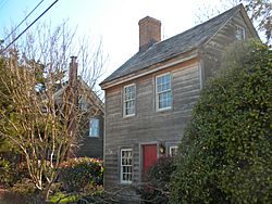
Owen Coachman House
Owen Coachman House
Official seal of Lower Township, New Jersey
Seal
Motto(s): 
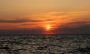
"Home of the Best Sunsets"
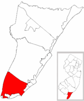
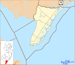
Location of Lower Township in Cape May County highlighted in red (left). Inset map: Location of Cape May County in New Jersey highlighted in red (right).
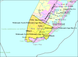
Census Bureau map of Lower Township, New Jersey
Lower Township, New Jersey is located in Cape May County, New Jersey
Lower Township, New Jersey
Location in Cape May County, New Jersey
Lower Township, New Jersey is located in New Jersey
Lower Township, New Jersey
Location in New Jersey
Lower Township, New Jersey is located in the United States
Lower Township, New Jersey
Location in the United States
Country  United States
State  New Jersey
County Cape May
Established April 2, 1723 (as precinct)
Incorporated February 21, 1798 (as township)
Government
 • Type Faulkner Act (council–manager)
 • Body Township Council
Area
 • Total 31.06 sq mi (80.45 km2)
 • Land 27.38 sq mi (70.91 km2)
 • Water 3.69 sq mi (9.54 km2)  11.86%
Area rank 84th of 565 in state
4th of 16 in county
Elevation
20 ft (6 m)
Population
 (2020)
 • Total 22,057
 • Estimate 
(2023)
21,886
 • Rank 127th of 565 in state
1st of 16 in county
 • Density 805.6/sq mi (311.0/km2)
 • Density rank 407th of 565 in state
10th of 16 in county
Time zone UTC−05:00 (Eastern (EST))
 • Summer (DST) UTC−04:00 (Eastern (EDT))
ZIP Code
08251 – Villas
Area code(s) 609 exchanges: 884, 886, 889, 898
FIPS code 3400941610
GNIS feature ID 0882044
Website

Lower Township is a township in Cape May County, in the U.S. state of New Jersey. The township, and all of Cape May County, is part of the Ocean City metropolitan statistical area, and is part of the Philadelphia-Wilmington-Camden, PA-NJ-DE-MD combined statistical area, also known as the Delaware Valley or Philadelphia metropolitan area. As of the 2020 United States census, the township's population was 22,057, a decrease of 809 (−3.5%) from the 2010 census count of 22,866, which in turn reflected a decrease of 79 (−0.3%) from the 22,945 counted in the 2000 census.

New Jersey Monthly magazine ranked Lower Township as its 34th best place to live in its 2008 rankings of the "Best Places To Live" in New Jersey. The township is part of the state's South Jersey region and the larger Delaware Valley or Philadelphia metropolitan area.

History

Before the region was settled by Europeans, the Kechemeche tribe of the Lenape Native Americans inhabited South Jersey, and traveled to the barrier islands during the summer to hunt and fish. On August 28, 1609, English explorer Henry Hudson entered the Delaware Bay and stayed one day on land, north of what is now Cape May Point. In 1630, representatives of the Dutch West India Company purchased a 16 sq mi (41 km2) tract of land along the Delaware from indigenous people, and additional land in the county was purchased 11 years later. Due to the large number of whales in the region of Cape May, Dutch explorers founded Town Bank around 1640 as a whaling village in what is now Lower Township. It was the first European settlement in Cape May County. The village once functioned as the court house for the county, along with Coxehall, built by Dr. Daniel Coxe to be a center for a manorial style of government. The sole remaining section of the original structure, which was moved several times during its history, is now preserved as Coxe Hall Cottage at Historic Cold Spring Village, a 19th century living history museum in Lower Township.

Lower Township was formed as a precinct on April 2, 1723, and was incorporated by an act of the New Jersey Legislature on February 21, 1798, as one of New Jersey's initial group of 104 townships established by the Township Act of 1798. The township's name came from its location when Cape May was split into three townships in 1723 at the same time that Middle Township and Upper Township were created.

Portions of the township were taken to form Cape Island Borough (March 8, 1848; now known as Cape May city), Cape May Point borough (created April 19, 1878; restored to Lower Township on April 8, 1896; re-created April 6, 1908), Holly Beach (April 14, 1885, now part of Wildwood city), South Cape May (August 27, 1894; restored to Lower Township after the borough was dissolved on April 30, 1945), Wildwood Crest (April 6, 1910), and North Cape May (March 19, 1928; restored to Lower Township after it was dissolved on April 30, 1945).

Geography

Cape may
Sunset at Sunset Beach in Lower Township

According to the U.S. Census Bureau, the township had a total area of 31.06 square miles (80.45 km2), including 27.38 square miles (70.91 km2) of land and 3.69 square miles (9.54 km2) of water (11.86%).

Census-designated places (CDPs) located within Lower Township include Diamond Beach (with a 2010 population of 136,), Erma (2,134), North Cape May (3,226) and Villas (9,483). Other unincorporated communities, localities and place names located partially or completely within the township include Bennett, Cold Spring, Cold Spring Inlet, Ephraims Island, Fishing Creek, Higbees Landing, Miami Beach, Schellengers Landing, Sewells Point, South Cape May, Sunset Beach, Town Bank, Weers Landing, and Wildwood Gables.

Schellengers Landing is where boats dock and where a bridge between Cape Island and the mainland is located. Schellengers Landing was named after people who moved from New England to New Jersey in the 1600s. There were multiple families with the Schellenger name who had settled the area. Schellengers Landing is connected to Cape May city via a bridge, and is on Route 109. The name of the community is spelled differently in different works.

Lower Township borders the Cape May County municipalities of Cape May City, Cape May Point Borough, Middle Township, West Cape May Borough, Wildwood City, Wildwood Crest Borough, and Delaware Bay and the Atlantic Ocean.

Demographics

Historical population
Census Pop.
1810 862
1820 1,001 16.1%
1830 999 −0.2%
1840 1,133 13.4%
1850 1,604 * 41.6%
1860 1,865 16.3%
1870 1,783 −4.4%
1880 1,779 * −0.2%
1890 1,156 * −35.0%
1900 1,141 * −1.3%
1910 1,188 * 4.1%
1920 1,096 −7.7%
1930 1,444 * 31.8%
1940 1,693 17.2%
1950 2,737 61.7%
1960 6,332 131.3%
1970 10,154 60.4%
1980 17,105 68.5%
1990 20,820 21.7%
2000 22,945 10.2%
2010 22,866 −0.3%
2020 22,057 −3.5%
2023 (est.) 21,886 −4.3%
Population sources: 1810–2000
1810–1920 1840 1850–1870
1850 1870 1880–1890
1890–1910 1910–1930
1940–2000 2000
2010 2020
* = Lost territory in previous decade

2010 census

The 2010 United States census counted 22,866 people, 9,579 households, and 6,351 families in the township. The population density was 824.3 per square mile (318.3/km2). There were 14,507 housing units at an average density of 523.0 per square mile (201.9/km2). The racial makeup was 94.24% (21,549) White, 1.99% (456) Black or African American, 0.16% (37) Native American, 0.62% (142) Asian, 0.04% (10) Pacific Islander, 1.20% (275) from other races, and 1.74% (397) from two or more races. Hispanic or Latino of any race were 4.24% (969) of the population.

Of the 9,579 households, 22.6% had children under the age of 18; 49.3% were married couples living together; 12.1% had a female householder with no husband present and 33.7% were non-families. Of all households, 28.7% were made up of individuals and 15.1% had someone living alone who was 65 years of age or older. The average household size was 2.38 and the average family size was 2.89.

19.8% of the population were under the age of 18, 7.6% from 18 to 24, 20.4% from 25 to 44, 31.0% from 45 to 64, and 21.1% who were 65 years of age or older. The median age was 46.5 years. For every 100 females, the population had 90.1 males. For every 100 females ages 18 and older there were 86.9 males.

The Census Bureau's 2006–2010 American Community Survey showed that (in 2010 inflation-adjusted dollars) median household income was $51,101 (with a margin of error of +/− $2,460) and the median family income was $62,587 (+/− $7,438). Males had a median income of $50,572 (+/− $3,361) versus $35,978 (+/− $2,297) for females. The per capita income for the borough was $28,175 (+/− $1,295). About 6.6% of families and 10.6% of the population were below the poverty line, including 20.4% of those under age 18 and 6.5% of those age 65 or over.

Education

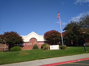
Lower Cape May Regional High School
Lower Cape May Regional High School in the Erma area
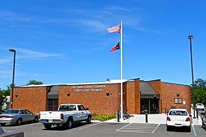
Lower Cape Branch Library NJ
Lower Township Branch, Cape May Library, on Bayshore Road in Villas CDP
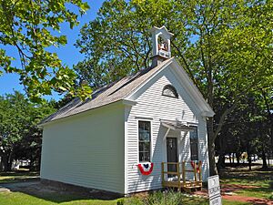
Fishing Creek School from NW
Fishing Creek Schoolhouse

Lower Township School District serves public-school students in pre-kindergarten through sixth grade. As of the 2020–21 school year, the district, comprised of four schools, had an enrollment of 1,519 students and 149.6 classroom teachers (on an FTE basis), for a student–teacher ratio of 10.2:1. Schools in the district (with 2020–21 enrollment data from the National Center for Education Statistics) are David C. Douglass Veterans Memorial School with 312 students in grades PreK-K (in Villas), Carl T. Mitnick School with 440 students in grades 1-2 (in Cold Spring), Maud T. Abrams School with 355 students in grades 3-4 (in Cold Spring), and Charles W. Sandman Consolidated School with 388 students in grades 5-6 (in Cold Spring). The Lower Township School District participates in the Interdistrict Public School Choice Program, which allows non-resident students to attend the district's schools without cost to their parents, with tuition paid by the state. Seats in the program for non-resident students are specified by the district and are allocated by lottery.

For seventh through twelfth grades, public-school students attend the schools of the Lower Cape May Regional School District, in the Erma area, which also serves students from Cape May City and West Cape May, along with students from Cape May Point who attend the district as part of a sending/receiving relationship. Schools in the district (with 2020–21 enrollment data from the National Center for Education Statistics) are Richard M. Teitelman Middle School with 480 students in grades 7-8, and Lower Cape May Regional High School with 750 students in grades 9-12. In the 2011–12 school year, the city of Cape May paid $6 million in property taxes to cover the district's 120 high-school students, an average of $50,000 per student attending the Lower Cape May district. Cape May officials have argued that the district's funding formula based on assessed property values unfairly penalizes Cape May, which has higher property values and a smaller number of high-school students as a percentage of the population than the other constituent districts, especially Lower Township. The district's board of education is comprisedof nine members, who are elected directly by voters to serve three-year terms of office on a staggered basis, with three seats up for election each year Seats on the board are allocated based on population, with Lower Township assigned seven seats.

Students are also eligible to attend Cape May County Technical High School in Cape May Court House, which serves students from the entire county in its comprehensive and vocational programs, which are offered without charge to students who are county residents. Special needs students may be referred to Cape May County Special Services School District in Cape May Court House.

Wildwood Catholic Academy (Pre-K–12) in North Wildwood, of the Roman Catholic Diocese of Camden, is the nearest Catholic school. Villas had its own Catholic K–8 school, St. Raymond's School, until 2007, when it merged into Our Lady Star of the Sea School in Cape May. In 2010 Our Lady Star of the Sea merged into Cape Trinity Regional School (Pre-K–8) in North Wildwood. That school in turn merged into Wildwood Catholic Academy in 2020. As of 2020 Bishop McHugh Regional School in Dennis Township takes students from Lower Township.

Two of the initial properties of Cape Christian Academy, formed c. 1990 as a merger of South Cape Christian Academy and Cape May County Christian School were in Lower Township. The current consolidated school building is in Middle Township, with a Cape May Courthouse postal address and within the CMCH census-designated place. Richard Degener of the Press of Atlantic City described it as being in Burleigh. Its campus has 6.5 acres (2.6 ha) of area.

Cape May County Library operates the Lower Township Library in Villas.

Transportation

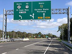
2020-09-12 10 36 31 View north along New Jersey State Route 109 at the exit for the Garden State Parkway NORTH in Lower Township, Cape May County, New Jersey
The Garden State Parkway northbound in Lower Township
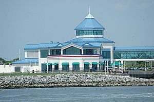
CMLF-CMTerminal
Cape May–Lewes Ferry terminal of the Cape May–Lewes Ferry

Roads and highways

As of May 2010, the township had a total of 179.10 miles (288.23 km) of roadways, of which 131.92 miles (212.30 km) were maintained by the municipality, 33.83 miles (54.44 km) by Cape May County and 6.87 miles (11.06 km) by the New Jersey Department of Transportation and 6.48 miles (10.43 km) by the New Jersey Turnpike Authority.

The most prominent highway serving Lower Township is the Garden State Parkway, which has its southern terminus at the intersection with Route 109, in the township. U.S. Route 9, Route 109, Route 162, and Ocean Drive are other significant roadways within Lower Township.

Public transportation

NJ Transit offers bus service on the 313 and 315 routes between Cape May / Wildwood / Philadelphia, on the 552 between Cape May and Atlantic City, with seasonal service on the 319 route serving shore points between Cape May and the Port Authority Bus Terminal in New York City's Midtown Manhattan.

The Cape May–Lewes Ferry terminal is located in North Cape May. Operated by the Delaware River and Bay Authority, the ferry makes the 17-mile (27 km) trip between Lower Township and Lewes, Delaware in 85 minutes, carrying passengers and vehicles. The Delaware River and Bay Authority operates a shuttle bus service that connects the ferry terminal with the Cape May Transportation Center in Cape May in the summer months and to the Cape May County Park & Zoo in July and August.

Cape May Airport is in Lower Township.

Points of interest

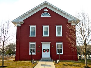
Cold Spring Presby
Cold Spring Presbyterian Church

Notable people

See also (related category): People from Lower Township, New Jersey

People who were born in, residents of, or otherwise closely associated with Lower Township include:

  • Bob Andrzejczak (born 1986), politician who represented the 1st Legislative District in the New Jersey General Assembly from 2013 to 2019 and in the New Jersey Senate in 2019
  • Maurice Catarcio (1929–2005), professional wrestler for the World Wrestling Federation and record holder in The Guinness Book of World Records
  • T. Millet Hand (1902–1956), politician who represented New Jersey's 2nd congressional district in the United States House of Representatives from 1945 to 1956
  • Chris Jay, (born 1978), musician, screenwriter, actor and member of the band Army of Freshmen
  • Michael Linnington (born 1958), CEO of Wounded Warrior Project
  • Charles W. Sandman Jr. (1921–1985), politician who represented New Jersey's 2nd congressional district from 1967 to 1975
  • Erik K. Simonsen, politician who represents the 1st Legislative District in the New Jersey General Assembly and had served as mayor of Lower Township from 2016 until 2020
  • Matt Szczur (born 1989), Major League Baseball outfielder
kids search engine
Lower Township, New Jersey Facts for Kids. Kiddle Encyclopedia.