Matamoros, Tamaulipas facts for kids
Quick facts for kids
Matamoros
|
||
|---|---|---|
|
City
|
||
| Heroica Matamoros | ||
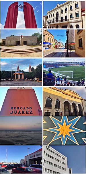
Above, from left to right: Great Gate of Mexico, Municipal Palace, Fort Casa Mata Historical Museum, Sixth Avenue, Main Square, El Hogar Stadium, Juárez Market, Reforma Theater, Bagdad Beach, Kiosk in Plaza Principal, Plaza Fiesta, and the building of the Judicial Power of the Federation.
|
||
|
||
| Nickname(s):
Siempre Heroica, Invicta y Leal
|
||
| Country | Mexico | |
| State | Tamaulipas | |
| Municipality | Matamoros Municipality | |
| Government | ||
| • Type | Municipality | |
| Elevation | 9 m (26.24 ft) | |
| Population
(2016)
|
||
| • City | 520,367 | |
| • Metro | 1,387,985 | |
| • Metro density | 4,431/km2 (11,480/sq mi) | |
| Time zone | UTC−6 (CST) | |
| • Summer (DST) | UTC−5 (CDT) | |
| ZIP Code |
87300
|
|
| Area code(s) | +52-868 | |
| Airport | General Servando Canales International Airport | |
| Website | matamoros.gob.mx | |
Matamoros, officially called Heroica Matamoros, is a big city in the northeastern Mexican state of Tamaulipas. It is the main city of the Matamoros area. The city sits on the southern bank of the Rio Grande. Right across the border is Brownsville, Texas, in the United States.
Matamoros is the second largest city in Tamaulipas. In 2016, about 520,367 people lived there. The larger area, including Brownsville, has over 1.3 million people. This makes it one of the biggest border areas between Mexico and the U.S. Matamoros is also the 39th largest city in Mexico.
The city's economy relies a lot on trade with the United States. This trade happens because of the USMCA deal. Matamoros has many factories, called maquiladoras, which make it an important industrial center. These factories build parts for cars from brands like General Motors and Ford. Before these factories grew, Matamoros was mostly known for farming. It has some of the best farming lands in northern Mexico. There are also plans for oil drilling projects near the port of Matamoros.
Matamoros has a rich history. Many important battles and events happened here. These include the Mexican War of Independence, the Mexican Revolution, and the Mexican–American War. Because of its brave defense in these events, the city earned the name "Undefeated, Loyal, and Heroic." The Mexican National Anthem was first played in public at the Reforma Theater in Matamoros.
The city has a semiarid climate, meaning it's quite dry. Winters are mild, and summers are hot and humid. Matamoros and Brownsville celebrate the Charro Days and Sombrero Festival every February. These festivals honor the shared history of the U.S. and Mexico.
Contents
Discovering Matamoros' Past
Early History and First People
The first people in this area were the Esto’k G’na. They are also known by their later name, the Carrizo Comecrudo Tribe of Texas. Many of their descendants still live in the Brownsville-Matamoros area today.
How Matamoros Began
In 1519, a Spanish captain named Alonso Álvarez de Pineda explored northern Tamaulipas. He named the Rio Grande the "Palms River." Later, in 1686, Captain Alonso de León explored the area. He thought the Rio Grande was great for boats and that Matamoros was perfect for raising cattle.
In 1749, thirteen families from nearby towns decided to start a cattle business here. People thought it wouldn't work because of floods and Native American attacks. But these families succeeded! They created many cattle ranches. In 1774, they officially named the area San Juan de los Esteros Hermosos. This is what Matamoros is called today.
In 1793, two missionaries built a church in Matamoros. They suggested a new name for the community: Villa del Refugio. This name honored their church and its patron saint.
Mexico's Fight for Freedom
In 1826, the city's name was changed to Matamoros. This honored Mariano Matamoros, a hero of the Mexican War of Independence. He fought alongside José María Morelos. During the Texas Revolution in 1836, Matamoros was a strong base for Mexican soldiers. They defended against rebel attacks.
In 1851, Matamoros showed its bravery again. It defended itself from attacks by troops led by José María Jesús Carbajal. Many of these attackers came from Texas. They wanted to create a federal republic against the Mexican government. Mexican troops successfully fought them off. Because of this, the state congress gave Matamoros the title "Heroic." This is why its official name is Heroica Matamoros.
The city changed a lot after it became a free trade zone in 1858. This meant goods could be traded without extra taxes. This led to more buildings, factories, and a bigger port called Bagdad Port. This port became very busy during the American Civil War. It was the only port where goods could enter for the Confederate States of America. The Port of Matamoros became one of the world's leading trade ports during that time.
The American Civil War's Impact
At the start of the American Civil War, Matamoros was a quiet border town. Few ships came to its port. But in just four years, Matamoros became a very important port. Its population grew a lot. A U.S. general in 1865 said Matamoros was like New York City for the Confederacy. It supplied them with food, clothes, weapons, and money.
The cotton trade brought over 20,000 traders to Bagdad and Matamoros. These traders came from the Union, the Confederacy, England, France, and Germany. Bagdad grew from a small outpost to a busy town. By 1864, so many English speakers lived there that Matamoros even had an English newspaper. The port sent cotton to England and France, where it was greatly needed. Cotton sold for much more money in Matamoros than in the Confederacy. Matamoros also traded with London, Havana, and New Orleans.
By 1865, Matamoros was a busy city of 30,000 people. General Lew Wallace told General Ulysses S. Grant that Matamoros's trade was bigger than Baltimore or New Orleans. But after the Confederacy lost the war, Matamoros became quiet again. Markets closed, businesses stopped, and ships rarely came. Matamoros returned to being a sleepy border town.
A huge hurricane in 1889 destroyed the Port of Bagdad. This storm, and others from 1870 to 1889, cut Matamoros's population almost in half. This caused another big economic problem for the city.
French Intervention and Modern Times
During the French intervention, the port of Bagdad was the site of a battle. The Mexican army defeated the French army and their allies there.
Later, during the Mexican Revolution, generals Francisco Mújica and Lucio Blanco started the first land reform in Mexico in 1913. This meant land was given to farmers. Matamoros then had a "Golden Era" from 1948 to 1962, known as The Cotton Age. During this time, Matamoros was the biggest cotton producer and exporter in Mexico.
Since the 1970s, and especially after the North American Free Trade Agreement started, many foreign companies invested in Matamoros. This led to a huge growth in population. Many people moved here from other Mexican states.
People of Matamoros
In 2020, the city of Matamoros had about 510,739 people. The entire Matamoros area had 541,979 people.
| Historical population | ||
|---|---|---|
| Year | Pop. | ±% |
| 2000 | 418,141 | — |
| 2005 | 462,157 | +10.5% |
| 2010 | 489,193 | +5.8% |
Matamoros' Economy
Factories and Trade
Matamoros' economy mainly depends on its closeness to the United States. Many foreign companies invest here. Factories called maquiladoras are a big part of this. They are often owned by American companies. Goods are traded across the international bridges, and people move between both sides of the border. This is very important for Matamoros' economy.
More than 122 maquiladoras are in Matamoros. Most of them make goods to send to the United States. These factories produce things like cables, electronics, car parts, and textiles. Matamoros has about 35% of all the maquiladora factories in Tamaulipas. This makes it the second largest factory center in the state, after Reynosa. In 2004, these factories employed over 52,777 workers.
Shopping and Businesses
Shopping and other businesses are the second most important part of Matamoros' economy. They create about 13.5% of all jobs in the city. Because Matamoros' population is growing fast and people have more money, there's a higher demand for goods and services. Matamoros has the most jobs and businesses created by foreign investment in Tamaulipas. It has 238 companies, which is 36% of the state's total business sector.
Farming and Ranching
The rural areas of Matamoros have 97 communities with over 36,096 people. Historically, Matamoros was a farming city. Farmers grew sorghum, corn, beans, and sunflowers. The land in Matamoros is used for two main things: grazing animals or growing crops.
Matamoros is located in the Rio Grande river basin. This means there is water for irrigation, which helps farming a lot. The two main water sources are the Rio Grande and the Arroyo del Tigre. They have dams that provide water to the region.
Raising animals is also important. Cattle are the most common livestock in Matamoros. Selling their meat is the main income for ranchers. About 62% of livestock are cattle, 16% are pigs, and 9% are sheep. Some ranchers in northern Tamaulipas raise special calves with European blood for high-quality meat.
Fishing Industry
Matamoros has over 117 kilometers (73 miles) of coastline along the Gulf of Mexico. It also has a large area of the Laguna Madre for fishing. Fishing happens in places like Higuerillas and Playa Bagdad. There are 10 fishing companies working in these areas.
Fun Things to Do in Matamoros
Bagdad Beach: Sun and Fun
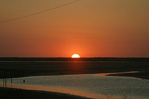
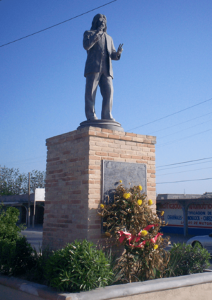
Bagdad Beach, also called Lauro Villar Beach, is about 27 kilometers (17 miles) east of Matamoros. Fishing tournaments are held here every year. People from all over Tamaulipas come to join. During Holy Week, many visitors come, especially from Nuevo León. The beach hosts concerts, sports events, and festivals during this time. In 2014, the mayor suggested changing the beach's name to Costa Azul. This was to honor Rigo Tovar, a famous singer from Matamoros.
Many famous bands and pop groups have played at Playa Bagdad, especially in April, which is the busiest time. The beach also has many seafood restaurants. You can enjoy jet skiing, surfing, and even motocross and off-road 4x4 racing. On a single day during summer breaks, up to 180,000 people can visit the beach!
Cultural Places to Visit
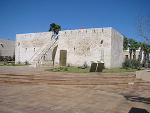
The Fortress of Casamata was once a strong fort. In 1970, it became the Museum Casamata. It has a great collection of ancient figures and items from different times in history. These include the time of Spanish rule, the Mexican War of Independence, and the Mexican Revolution. You can also see unique items like an iron box where General Canales' remains once rested. He fought against American and French invasions. There are also dark tunnels under the building, which are part of local spooky stories! The museum also has a hall for events and a newspaper library. Don Eliseo Paredes Manzano, the city's first historian, founded the museum.
The 'Museo de Arte Contemporáneo de Tamaulipas (MACT)' opened in 1969. It is the biggest and most important art museum in Matamoros. It's also one of the most famous in Tamaulipas. Art and photo shows are held there all year. Artworks from cities like Mexico City, New York, and Paris have been shown at this museum.
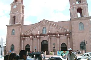
The main 'plaza' (town square) in Matamoros is home to the Presidential Offices and the Cathedral of Nuestra Señora Villa del Refugio. The Casino Matamorense and other historic buildings are also there. The 'Teatro Reforma', the city's most important theater, is a few blocks away. On January 28, 1829, the plaza was named after Miguel Hidalgo y Costilla. He was a hero who fought in the Mexican War of Independence.
The Cathedral of Nuestra Señora Villa del Refugio was built in 1831. It was one of the first major buildings and is a symbol of the city today. Its beautiful neoclassical architecture and rich history attract visitors all year. The Casino Matamorense, built in 1950, has traditionally been a place for social gatherings for the city's main families. The Centro Cultural Olimpico is another unique building. Finally, the 'Teatro Reforma' was built in 1861. It was once called the 'House of the Opera of the 19th Century'. For many years, it hosted important parties for the richest families and military officers. It is also famous for being the first place where the Mexican National Anthem was played.
On April 10, 2002, the Museum of Mexican Agrarianism was founded. It has a collection about farming and land reform in Mexico.
Medical Visits
Matamoros is a place where people from the U.S. sometimes go for medical care or cosmetic surgery. The prices for these services can be lower than in the United States.
Matamoros' Location and Weather
Where is Matamoros?
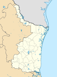
The city is on the southern bank of the Rio Grande. It is right across the border from Brownsville, Texas, in the United States.
Matamoros' Climate
Matamoros has a warm humid subtropical climate. This means it has mild winters and hot, humid summers. Because it's close to the Gulf of Mexico, it gets cooler winds in summer and winter. This makes it a bit cooler than nearby cities like Reynosa, which are further inland. Summer temperatures usually range from 30 to 40 degrees Celsius (86 to 104 degrees Fahrenheit). Temperatures above 38°C (100°F) are rare, and freezing temperatures in winter are also very uncommon.
Heavy rain usually falls in July and August. However, sometimes there is no rain at all during the "wet" season. Winter temperatures are usually around 0 to 10 degrees Celsius (32 to 50 degrees Fahrenheit). Winters often bring rain, drizzle, and fog. The last time it snowed was on December 25, 2004. This was the heaviest snowfall ever recorded in the city, with about 3.8 centimeters (1.5 inches) in one day. Even though it's near the humid Gulf Coast, the city is quite dry. It gets about 698 millimeters (27.4 inches) of rain each year.
| Climate data for Matamoros/Brownsville | |||||||||||||
|---|---|---|---|---|---|---|---|---|---|---|---|---|---|
| Month | Jan | Feb | Mar | Apr | May | Jun | Jul | Aug | Sep | Oct | Nov | Dec | Year |
| Record high °C (°F) | 34 (93) |
34 (94) |
41 (106) |
39 (102) |
39 (102) |
39 (103) |
39 (103) |
41 (105) |
41 (105) |
37 (99) |
37 (98) |
34 (94) |
41 (106) |
| Mean daily maximum °C (°F) | 21.5 (70.7) |
23.3 (73.9) |
26.1 (79.0) |
28.8 (83.9) |
31.4 (88.6) |
33.5 (92.3) |
34.3 (93.7) |
34.7 (94.5) |
32.6 (90.6) |
29.8 (85.7) |
26.2 (79.2) |
22.2 (72.0) |
28.7 (83.7) |
| Daily mean °C (°F) | 16.2 (61.2) |
17.9 (64.3) |
20.7 (69.3) |
23.8 (74.9) |
26.9 (80.4) |
28.9 (84.0) |
29.4 (85.0) |
29.7 (85.4) |
27.7 (81.8) |
24.6 (76.3) |
20.8 (69.4) |
16.8 (62.3) |
23.6 (74.5) |
| Mean daily minimum °C (°F) | 10.9 (51.6) |
12.6 (54.7) |
15.3 (59.6) |
18.8 (65.9) |
22.4 (72.3) |
24.3 (75.7) |
24.6 (76.3) |
24.6 (76.2) |
22.8 (73.1) |
19.4 (66.9) |
15.3 (59.6) |
11.5 (52.7) |
18.6 (65.4) |
| Record low °C (°F) | −8 (18) |
−11 (12) |
−2 (28) |
3 (37) |
5 (41) |
13 (56) |
14 (57) |
16 (60) |
11 (51) |
2 (35) |
−3 (27) |
−9 (15) |
−11 (12) |
| Average precipitation mm (inches) | 32 (1.27) |
27 (1.07) |
31 (1.23) |
39 (1.53) |
67 (2.64) |
65 (2.56) |
52 (2.04) |
62 (2.44) |
150 (5.92) |
95 (3.74) |
46 (1.81) |
29 (1.15) |
696 (27.41) |
| Average precipitation days (≥ 0.01 in) | 7.3 | 5.5 | 4.4 | 4.0 | 4.9 | 5.9 | 5.3 | 6.6 | 10.0 | 7.5 | 6.0 | 7.0 | 74.4 |
| Mean monthly sunshine hours | 130.2 | 152.6 | 207.7 | 234.0 | 266.6 | 306.0 | 334.8 | 306.9 | 252.0 | 229.4 | 165.0 | 130.2 | 2,715.4 |
| Source 1: NOAA (normals 1981–2010) | |||||||||||||
| Source 2: Hong Kong Observatory (sun, 1961–1990) | |||||||||||||
Bridges Connecting Countries
Matamoros is the only border city between the U.S. and Mexico that has four international bridges. These bridges help a lot with trade and travel between the two countries.
- Brownsville & Matamoros International Bridge: People call this the "Old Bridge" because it was built in 1904.
- Gateway International Bridge: This is known as the "New Bridge." It connects downtown Matamoros to Brownsville, Texas. It's the most used bridge for people walking across the border.
- Veterans International Bridge: This is often called "Los Tomates Bridge." It's the biggest and newest bridge in the Matamoros-Brownsville area.
- Free Trade International Bridge: This bridge is known as "Los Indios Bridge." It crosses the Rio Grande and connects Matamoros to Los Indios, Texas.
Famous People from Matamoros
Many notable people have come from Matamoros:
- Manuel González Flores (1833–1893): A soldier and politician who became the President of Mexico.
- Pedro Hinojosa (1820–1903): A military officer and politician who served as governor of several states.
- Lauro Villar Ochoa (1865–1913): A Mexican general who defended Francisco I. Madero.
- Gregorio Cortez (1875–1916): A Mexican American who became a folk hero in South Texas.
- Rigo Tovar (1946–2005): A famous Cumbia singer who mixed electric guitars and rock music with traditional Mexican sounds.
- Carlos Cascos (born 1952): A politician who became the Secretary of State of Texas.
- Carlos de los Cobos (born 1958): A former soccer player and manager who played in the World Cup '86.
- Cristina Rivera Garza (born 1964): A Mexican writer who won the prestigious Sor Juana Inés de la Cruz Prize twice.
- Raúl Gárate Legleú (1896–1977): A military general and former governor of Tamaulipas.
- Guadalupe Mainero (1856–1912): A lawyer, journalist, and governor of Tamaulipas.
- Eliseo Paredes Manzano (1899–1988): A businessman and journalist who served as mayor of Matamoros.
- Carlos Quintero Lamar (1863–1933): A lawyer and diplomat who served as a consul in Costa Rica and New Orleans.
- Raúl Brindis (born 1963): A Mexican radio personality.
Sister Cities
- Brownsville, Texas (since 2009)
See also
 In Spanish: Heroica Matamoros para niños
 | Roy Wilkins |
 | John Lewis |
 | Linda Carol Brown |


