
Kingsville, Texas facts for kids
Quick facts for kids
Kingsville, Texas
|
|
|---|---|

Downtown Kingsville
|
|
 |
|

Kingsville, Texas
Location in Texas

Kingsville, Texas
Location in the United States
|
|
| Country | |
| State | |
| County | Kleberg |
| Settled | July 4, 1904 |
| Incorporated | 1911 |
| Named for | Richard King |
| Government | |
| • Type | Council-Manager |
| Area | |
| • City | 13.91 sq mi (36.02 km2) |
| • Land | 13.88 sq mi (35.96 km2) |
| • Water | 0.02 sq mi (0.06 km2) |
| Elevation | 59 ft (18 m) |
| Population
(2020)
|
|
| • City | 25,402 |
| • Estimate
(2022)
|
24,833 |
| • Density | 1,769.40/sq mi (684.27/km2) |
| • Metro | 34,367 |
| Demonym(s) | Kingsvillian |
| Time zone | UTC-6 (Central (CST)) |
| • Summer (DST) | UTC-5 (CDT) |
| ZIP codes |
78363-78364
|
| Area code(s) | 361 |
| FIPS code | 48-39352 |
| GNIS feature ID | 1374386 |
Kingsville is a city in southern Texas. It is the main city of Kleberg County. Kingsville is located on U.S. Route 77, between Corpus Christi and Harlingen. In 2020, about 25,402 people lived there.
The city is named after Richard King. He founded the famous King Ranch. Kingsville was started to support the ranch. It also became the main office for the new St. Louis, Brownsville and Mexico Railway. The first train tracks were laid in 1904. The city was officially formed in 1911. Kingsville is home to Texas A&M University-Kingsville. It also has Naval Air Station Kingsville. This is one of two places where U.S. Navy pilots train for jet aviation.
Contents
- Kingsville's Story: A Look Back in Time
- Where is Kingsville? Geography and Nature
- People of Kingsville: Demographics
- Kingsville's Economy: How People Make a Living
- Learning in Kingsville: Schools and Colleges
- Getting Around: Transportation in Kingsville
- Famous People from Kingsville
- Images for kids
- See also
Kingsville's Story: A Look Back in Time
The history of Kingsville is closely linked to its main creek, Santa Gertrudis. The first people here were the Coahuiltecan Malaquites. They lived off seafood from Baffin Bay. Their homes were along the Santa Gertrudis and San Fernando creeks. Wild horses used to roam the plains. They often drank from the springs around what is now Kingsville.
In 1803, Jose Lorenzo de la Garza started a settlement here. In 1846, General Zachary Taylor and his army camped by the Santa Gertrudis. This was before they went into Mexico. In 1899, water was found deep underground. This discovery by Robert J. Kleberg, Jr., helped a new town grow next to the King Ranch.
How Kingsville Grew in the 1900s
As the King Ranch got bigger, people wanted a railroad. It would connect the Rio Grande Valley to the rest of Texas. It would also serve the King Ranch. In the early 1900s, Henrietta King, Richard King's widow, gave land. This was to help build a town and bring a railroad.
In 1903, Robert J. Kleberg, Jr., created a company. Its job was to plan and build the town. In 1904, the town was planned about 3 miles (5 km) from the King Ranch. It was named after Richard King. The town also became the main office for the new St. Louis, Brownsville and Mexico Railway. The first train came through Kingsville on July 4, 1904. This is seen as the city's founding date. The first post office opened that year too.
By 1910, Kingsville had many businesses. A library opened in 1909. An opera house was built in 1910. In 1911, Kingsville became an official city. In 1913, it was named the county seat of the new Kleberg County. Around 1920, oil and natural gas were found nearby. This made Kingsville's population grow fast.
In the early 1900s, Kingsville had separate communities. There were areas for Spanish-speaking people, African-Americans, and Anglo-Americans. Schools and churches were also often separate.
Education and Military Growth
In 1925, the South Texas Teachers College opened. It was one of only six teacher training schools in Texas. This school later became Texas A&M University-Kingsville in 1993. It joined the Texas A&M University System. The university offers many degrees. It also has special research centers. These include the National Natural Toxins Research Center.
During World War II, leaders wanted a military airfield in Kingsville. In 1941, a naval air station opened in nearby Corpus Christi. After the attack on Pearl Harbor, more pilot training was needed. So, in 1942, the U.S. Navy opened Naval Air Auxiliary Station Kingsville. It is just east of town. After the war, it closed for a short time. But it reopened in 1951 and has been open ever since. NAS Kingsville is one of three main jet training places for the Navy. It has greatly helped Kingsville's economy and history.
Several big companies have been in Kingsville. In 1944, the Celanese Corporation opened a plant. It is still working today. In the early 1960s, Humble Oil and Refining Company (now Exxon) moved an office here. This was because Kingsville was close to oil fields. Kingsville's population grew steadily. It reached almost 30,000 people in the mid-1980s. Since then, the city has seen some economic changes.
Where is Kingsville? Geography and Nature
Kingsville is in South Texas. It is about 33 miles (53 km) southwest of Corpus Christi. It is also about 91 miles (146 km) north of Harlingen. The city covers about 13.9 square miles (36.0 km²). Most of this is land.
Kingsville is in the Gulf Coastal Plain region. This area is called the Texas Coastal Bend. It is next to the Gulf of Mexico and Baffin Bay. To the north, west, and south is the South Texas Plains. You can find Mesquite trees and many types of cacti here. Several creeks flow through the city. These include the San Fernando, Santa Gertrudis, and Escondido Creeks. They all flow into Baffin Bay.

Kingsville is in the historic Wild Horse Desert. This area once had huge herds of wild mustangs. Today, there are fewer spring-fed creeks. Wildlife around Kingsville includes deer, wild turkey, and javelinas. Many waterfowl like geese, ducks, and pelicans spend winter here. The city is surrounded by farms. They grow crops like cotton and sorghum. The land around Kingsville is mostly flat. The city center is 59 feet (18 meters) above sea level.
The city was planned in a grid system. It has many neighborhoods and shopping areas. These are mostly north and south of downtown. Historic downtown has buildings from the early 1900s. Texas A&M University-Kingsville is in the northwest. Naval Air Station Kingsville is east of U.S. Highway 77. Several buildings in Kingsville are on the National Register of Historic Places. These include the Kleberg County Courthouse and the John B. Ragland Mercantile Company Building.
Kingsville's Climate: Weather and Storms
The weather in Kingsville has hot, humid summers. Winters are usually mild to cool. Kingsville has a humid subtropical climate. This means it gets a lot of rain and has warm temperatures. Because it's close to the Gulf of Mexico, Kingsville can be hit by hurricanes and tropical storms. In 1916, a strong hurricane hit Baffin Bay. It caused a lot of damage in Kingsville.
| Climate data for Kingsville, Texas, 1991–2020 normals, extremes 1951–present | |||||||||||||
|---|---|---|---|---|---|---|---|---|---|---|---|---|---|
| Month | Jan | Feb | Mar | Apr | May | Jun | Jul | Aug | Sep | Oct | Nov | Dec | Year |
| Record high °F (°C) | 94 (34) |
101 (38) |
103 (39) |
108 (42) |
107 (42) |
111 (44) |
107 (42) |
108 (42) |
111 (44) |
101 (38) |
98 (37) |
93 (34) |
111 (44) |
| Mean maximum °F (°C) | 84.5 (29.2) |
89.0 (31.7) |
92.8 (33.8) |
96.6 (35.9) |
97.6 (36.4) |
100.3 (37.9) |
101.3 (38.5) |
102.4 (39.1) |
99.3 (37.4) |
94.9 (34.9) |
89.4 (31.9) |
85.4 (29.7) |
104.5 (40.3) |
| Mean daily maximum °F (°C) | 68.4 (20.2) |
72.4 (22.4) |
77.8 (25.4) |
84.2 (29.0) |
88.9 (31.6) |
93.7 (34.3) |
95.5 (35.3) |
96.7 (35.9) |
91.7 (33.2) |
86.1 (30.1) |
77.1 (25.1) |
70.3 (21.3) |
83.6 (28.7) |
| Daily mean °F (°C) | 57.5 (14.2) |
61.8 (16.6) |
67.3 (19.6) |
73.8 (23.2) |
79.6 (26.4) |
84.4 (29.1) |
85.6 (29.8) |
86.4 (30.2) |
82.0 (27.8) |
75.2 (24.0) |
66.2 (19.0) |
59.6 (15.3) |
73.3 (22.9) |
| Mean daily minimum °F (°C) | 46.6 (8.1) |
51.2 (10.7) |
56.9 (13.8) |
63.4 (17.4) |
70.3 (21.3) |
75.1 (23.9) |
75.8 (24.3) |
76.1 (24.5) |
72.4 (22.4) |
64.2 (17.9) |
55.3 (12.9) |
48.9 (9.4) |
63.0 (17.2) |
| Mean minimum °F (°C) | 31.2 (−0.4) |
34.7 (1.5) |
38.8 (3.8) |
46.4 (8.0) |
57.2 (14.0) |
68.6 (20.3) |
70.8 (21.6) |
70.9 (21.6) |
61.8 (16.6) |
46.1 (7.8) |
36.9 (2.7) |
31.0 (−0.6) |
28.2 (−2.1) |
| Record low °F (°C) | 11 (−12) |
17 (−8) |
24 (−4) |
33 (1) |
40 (4) |
54 (12) |
63 (17) |
60 (16) |
47 (8) |
32 (0) |
27 (−3) |
10 (−12) |
10 (−12) |
| Average precipitation inches (mm) | 1.51 (38) |
1.25 (32) |
1.94 (49) |
1.49 (38) |
3.99 (101) |
2.95 (75) |
2.25 (57) |
2.80 (71) |
6.04 (153) |
3.29 (84) |
1.92 (49) |
1.52 (39) |
30.95 (786) |
| Average snowfall inches (cm) | 0.0 (0.0) |
0.0 (0.0) |
0.0 (0.0) |
0.0 (0.0) |
0.0 (0.0) |
0.0 (0.0) |
0.0 (0.0) |
0.0 (0.0) |
0.0 (0.0) |
0.0 (0.0) |
0.0 (0.0) |
0.1 (0.25) |
0.1 (0.25) |
| Average precipitation days (≥ 0.01 in) | 7.0 | 6.3 | 6.2 | 5.5 | 5.9 | 5.5 | 5.1 | 4.9 | 9.6 | 5.2 | 6.3 | 6.0 | 73.5 |
| Average snowy days (≥ 0.1 in) | 0.0 | 0.0 | 0.0 | 0.0 | 0.0 | 0.0 | 0.0 | 0.0 | 0.0 | 0.0 | 0.0 | 0.0 | 0.0 |
| Source 1: NOAA | |||||||||||||
| Source 2: National Weather Service | |||||||||||||
People of Kingsville: Demographics
| Historical population | |||
|---|---|---|---|
| Census | Pop. | %± | |
| 1920 | 4,770 | — | |
| 1930 | 6,815 | 42.9% | |
| 1940 | 7,782 | 14.2% | |
| 1950 | 16,898 | 117.1% | |
| 1960 | 25,297 | 49.7% | |
| 1970 | 28,995 | 14.6% | |
| 1980 | 29,949 | 3.3% | |
| 1990 | 25,276 | −15.6% | |
| 2000 | 25,575 | 1.2% | |
| 2010 | 26,213 | 2.5% | |
| 2020 | 25,402 | −3.1% | |
| U.S. Decennial Census | |||
In 2009, Kingsville had about 1,849 people per square mile (714 per km²). There were about 10,427 homes.
Kingsville's Population in 2020
| Race | Number | Percentage |
|---|---|---|
| White (NH) | 4,891 | 19.25% |
| Black or African American (NH) | 966 | 3.8% |
| Native American or Alaska Native (NH) | 68 | 0.27% |
| Asian (NH) | 759 | 2.99% |
| Pacific Islander (NH) | 1 | 0.0% |
| Some Other Race (NH) | 81 | 0.32% |
| Mixed/Multi-Racial (NH) | 360 | 1.42% |
| Hispanic or Latino | 18,276 | 71.95% |
| Total | 25,402 |
In 2020, Kingsville had 25,402 people. There were 9,399 households and 5,813 families.
A Look at Kingsville's Homes and Families (2007-2011)
About 25,994 people lived in Kingsville. There were 9,103 households and 5,837 families. Most homes (57.1%) were built between 1950 and 1979. The average home value was $69,500.
About 36.5% of households had children under 18. About 40.6% were married couples. About 25.0% of households had one person living alone. The average household had 2.67 people.
The city's population was diverse. About 72.4% of people were Hispanic or Latino. The median age was 27.6 years old. About 30.1% of the population was under 20.
The median household income was $33,785. The median family income was $43,167. About 27.7% of the population lived below the poverty line.
Kingsville's Economy: How People Make a Living
Kingsville's economy relies on several things. These include farming, oil and natural gas, chemical making, tourism, and the military. Westwater Resources has a uranium mine in Kingsville. It has produced a lot of uranium.
Naval Air Station Kingsville (NAS Kingsville) is very important to the city's economy. It opened in 1942. Today, about one in seven people in the Kingsville area are connected to the base. The base employs over 1,600 people.
Learning in Kingsville: Schools and Colleges
Schools for Kids: Primary and Secondary Education
Kingsville has several school districts. These include Kingsville Independent School District (KISD), Ricardo Independent School District, and Santa Gertrudis Independent School District (SGISD).
There are two high schools in Kingsville:
- Henrietta M. King Early College High School (KISD)
- Academy High School (SGISD)
Other KISD schools include John S. Gillett Middle School. There are also several elementary schools. SGISD has one elementary and junior high school.
Private schools in Kingsville include Epiphany Episcopal School and Christian Life Academy. The Presbyterian Pan American School is also here.
Higher Education: Colleges and Universities

The main campus of Texas A&M University-Kingsville (TAMUK) is in the northwest part of the city. The Irma Lerma Rangel College of Pharmacy is also on the TAMUK campus.
Coastal Bend College has a campus in Kingsville. It offers various certificate and associate degree programs.
Getting Around: Transportation in Kingsville
Major Roads
 U.S. Highway 77 (
 Interstate 69E)
 State Highway 141
Airports
- Kleberg County Airport (in Kingsville)
- Corpus Christi International Airport (in Corpus Christi)
Railroad
Famous People from Kingsville
Kingsville has been home to many notable people, including:
- Lynn Adams, a professional golfer.
- Santa Barraza, a visual artist.
- Ronnie Bull, a professional football player.
- Laura Canales, a Tejano musician.
- Brothers Lauro Cavazos and Richard E. Cavazos. Lauro was the first Hispanic to serve in the U.S. Cabinet. Richard was the U.S. Army's first Hispanic four-star general.
- Chuck Clements, a quarterback for the New York Jets.
- Matthew Dear, a music producer and DJ.
- Steve Denton, a professional tennis player and coach.
- Donald Hollas, a professional football player.
- James Jefferson, a professional football player.
- Zona Jones, a country music singer and attorney.
- Richard M. Kleberg, a U.S. Representative and heir to King Ranch.
- Carmen Lomas Garza, a visual artist and illustrator.
- J. M. Lozano, a member of the Texas House of Representatives.
- Jack Mildren, an All-American quarterback and Lieutenant Governor of Oklahoma.
- Jim Morrison, a musician.
- Dwayne Nix, a football player in the College Football Hall of Fame.
- Luke Patterson, a professional football player.
- Kit Pongetti, an actress, singer, and writer.
- Irma Rangel, a lawyer and state representative.
- Kimberly Scott, an actress.
- Willie Wood, a professional golfer.
Images for kids
-
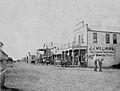
Kingsville, 1908
-
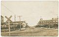
Kingsville, c. 1910s
-
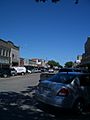
Kingsville, 2011
-
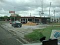
Damage from Tropical Storm Hermine in 2010
.jpg)
.jpg)


See also
 In Spanish: Kingsville (Texas) para niños
