Washabaugh County, South Dakota facts for kids
Quick facts for kids
Washabaugh County, South Dakota
|
|
|---|---|

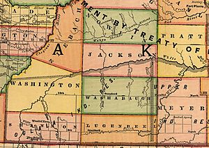
Map of Washabaugh County showing its boundaries in 1892
|
|
| County | United States |
| State | South Dakota |
| Established | March 9, 1883 |
| Dissolved | January 1, 1983 |
| Area | |
| • Total | 1,061 sq mi (2,750 km2) |
| Elevation | 2,713 ft (827 m) |
| Population
(1970)
|
|
| • Total | 1,389 |
| • Density | 1.3/sq mi (0.5/km2) |
| GNIS feature ID | 1265805 |
Washabaugh County was a special type of area called a county in South Dakota. It was named after Frank J. Washabaugh. He was an important politician in South Dakota's history. This county no longer exists today.
Contents
History of Washabaugh County
Washabaugh County was first created on March 9, 1883. It was part of Dakota Territory at that time. It was formed from a piece of land that used to be Lugenbeel County. When South Dakota became a state in 1889, Washabaugh continued as one of its counties.
Becoming Part of Jackson County
For many years, Washabaugh County was considered an "unorganized county." This meant it did not have its own local government. Instead, other counties helped manage its legal matters. Finally, on January 1, 1983, Washabaugh County officially joined with Jackson County. It became part of Jackson County and no longer existed as a separate county.
Proposed State of Absaroka
In the late 1930s, there was an idea to create a new state called Absaroka. This proposed state would have included parts of South Dakota, Wyoming, and Montana. Washabaugh County was planned to be part of this new state. However, the idea for Absaroka never became a reality.
Geography and Location
Washabaugh County was located in a unique part of South Dakota. It included the northeast corner of the Pine Ridge Indian Reservation. A community called Wanblee was also within its borders.
Changing Borders Over Time
The eastern part of Washabaugh County was once part of the Rosebud Indian Reservation. But in 1911, this area was added to the new Mellette County. By 1914, Washabaugh County's size grew. It gained land from Washington County to its west. It also took over all of Jackson County that was south of the White River.
Population and Demographics
Because Washabaugh was an unorganized county, its population was counted differently for a while. It was located entirely within two American Indian reservations. This meant its population was included with the total numbers for the Pine Ridge and Rosebud reservations. This happened during the 1890, 1900, and 1910 censuses.
First Separate Population Counts
Washabaugh County began reporting its own population numbers in the 1920 Census. The table below shows how its population changed over the years.
| 1890 | 1900 | 1910 | 1920 | 1930 | 1940 | 1950 | 1960 | 1970 |
|---|---|---|---|---|---|---|---|---|
| 1,166 | 2,474 | 1,980 | 1,551 | 1,042 | 1,389 |
 | Toni Morrison |
 | Barack Obama |
 | Martin Luther King Jr. |
 | Ralph Bunche |

