
National Register of Historic Places listings in Gregory County, South Dakota facts for kids

Imagine a special list that helps protect important old buildings and places in the United States. That's what the National Register of Historic Places is! It's like a hall of fame for historic sites. This list shows all the amazing places in Gregory County, South Dakota, that are on this special list.
These places are important because they tell us about the past. They show us how people lived, worked, and built communities long ago. Gregory County has 12 different properties and areas that are listed on the National Register.
Discover Historic Sites in Gregory County
Gregory County is home to many interesting places that have been recognized for their history. Let's explore some of these special spots!
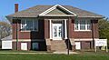
Dallas Carnegie Library: A Place for Books
The Dallas Carnegie Library is a beautiful old building in Dallas. It was added to the National Register in 1976. Libraries like this one were often built with money from Andrew Carnegie, a famous businessman who believed in the power of reading and education. This library helped people in Dallas learn and grow for many years.

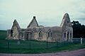
Fort Randall: A Frontier Outpost
Near Pickstown, you'll find Fort Randall. This fort was built a long time ago, in 1856, to help keep peace and protect settlers in the area. It played an important role in the history of the American frontier. The fort was added to the National Register in 1976.

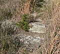
Gregory Buttes Stone Steps: Steps Through Time
In the town of Gregory, there are unique Gregory Buttes Stone Steps. These steps were built between the 11th and 14th Streets. They were added to the National Register in 2004. These steps are a cool example of how communities built their towns in the past.
_detail_1.JPG)
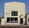
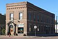
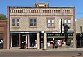
Fairfax's Old Bank: Gregory County State Bank
The Gregory County State Bank building in Fairfax is another historic site. It's located on Main Street. This building, added to the National Register in 1998, shows us what banks looked like and how they operated in earlier times.

Gregory National Bank: A Grand Building
Also in Gregory, the Gregory National Bank building stands on Main Street. This impressive building was listed in 2013. It's a great example of the architecture used for important buildings in the early 1900s.

Herrick Elevator: A Landmark for Farmers
The Herrick Elevator is a tall structure in Herrick, located along U.S. Route 18. Grain elevators were super important for farmers to store and sell their crops. This elevator, listed in 2003, reminds us of the area's farming history.

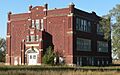
Herrick Public School: Learning in the Past
The Herrick Public School building in Herrick was added to the National Register in 2000. Located on 8th Street, this school taught many generations of students. It shows us what school buildings looked like and how education was provided in the past.
_from_NE_1.JPG)
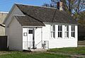
Pocahontas Schoolhouse: A Small School with Big History
The Pocahontas Schoolhouse is near 5th and Main in Gregory. This small schoolhouse, listed in 1973, is a classic example of a one-room school. Many children in rural areas learned their ABCs and math in places just like this.
_from_SW_1.JPG)
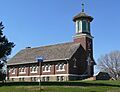
St. Augustine Church: A Community Gathering Place
In Dallas, the St. Augustine Church is a historic church building. It was added to the National Register in 2009. Churches like St. Augustine were often the heart of a community, serving as places for worship and social gatherings.
_from_NE_1.JPG)
St. John's Catholic Church: A Rural Gem
Near Dallas, in the unincorporated area of Paxton, you'll find St. John's Catholic Church. This beautiful church was listed in 2009. It's a great example of a historic church in a rural setting, showing the importance of faith in early communities.
_interior_1.JPG)
Tackett Underwood Building: Main Street History
The Tackett Underwood Building is located on Main Street in Gregory. This building, listed in 1999, is a good example of a historic commercial building. It likely housed businesses that served the community many years ago.

Images for kids
-
The historic Dallas Carnegie Library.
-
A view of Fort Randall.
-
Close-up of the Gregory Buttes Stone Steps.
-
The old Gregory County State Bank building.
-
The Gregory National Bank building.
-

The Herrick Elevator.
-
The Herrick Public School.
-
The Pocahontas Schoolhouse.
-
St. Augustine Church.
-
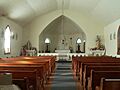
Inside St. John's Catholic Church.
-
The Tackett Underwood Building.
