Gregory, South Dakota facts for kids
Quick facts for kids
Gregory, South Dakota
|
|
|---|---|

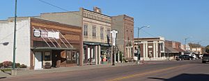
Main Street
|
|

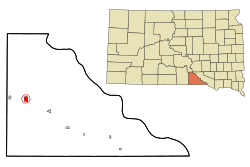
Location in Gregory County and the state of South Dakota
|
|
| Country | United States |
| State | South Dakota |
| County | Gregory |
| Incorporated | December 7, 1908 |
| Government | |
| • Type | Aldermanic Form |
| Area | |
| • Total | 1.72 sq mi (4.46 km2) |
| • Land | 1.72 sq mi (4.46 km2) |
| • Water | 0.00 sq mi (0.00 km2) |
| Elevation | 2,169 ft (661 m) |
| Population
(2020)
|
|
| • Total | 1,221 |
| • Density | 709.47/sq mi (273.92/km2) |
| Time zone | UTC−6 (Central (CST)) |
| • Summer (DST) | UTC−5 (CDT) |
| ZIP code |
57533
|
| Area code(s) | 605 |
| FIPS code | 46-26180 |
| GNIS feature ID | 1267408 |
| Website | http://www.cityofgregory.com/ |
Gregory is a city located in the western part of Gregory County, in the state of South Dakota, United States. In 2020, about 1,221 people lived there.
Contents
A Look at Gregory's Past
Gregory started as a town in 1904. It was named after Gregory County, where it is located. A post office has been open in Gregory since 1904. The local newspaper, the Gregory Times-Advocate, began in 1910.
On May 8, 1965, a very strong tornado hit the town. Luckily, no one was killed.
Where is Gregory?
Gregory is found along U.S. Route 18 and South Dakota Highway 47. It is between the towns of Burke (seven miles southeast) and Dallas (four miles west).
Ponca Creek flows about two miles south of Gregory. The start of South Fork Whetstone Creek is to the northeast.
The United States Census Bureau says that Gregory covers about 1.71 square miles (4.43 square kilometers) of land. There is no water area within the city limits.
Weather in Gregory
| Climate data for Gregory, South Dakota (1991−2020 normals, extremes 1906−present) | |||||||||||||
|---|---|---|---|---|---|---|---|---|---|---|---|---|---|
| Month | Jan | Feb | Mar | Apr | May | Jun | Jul | Aug | Sep | Oct | Nov | Dec | Year |
| Record high °F (°C) | 71 (22) |
76 (24) |
91 (33) |
98 (37) |
103 (39) |
107 (42) |
114 (46) |
113 (45) |
105 (41) |
97 (36) |
85 (29) |
79 (26) |
114 (46) |
| Mean maximum °F (°C) | 57.0 (13.9) |
61.1 (16.2) |
74.9 (23.8) |
82.0 (27.8) |
88.9 (31.6) |
93.6 (34.2) |
100.3 (37.9) |
98.2 (36.8) |
93.7 (34.3) |
85.2 (29.6) |
72.2 (22.3) |
57.9 (14.4) |
101.2 (38.4) |
| Mean daily maximum °F (°C) | 31.6 (−0.2) |
35.9 (2.2) |
46.8 (8.2) |
57.6 (14.2) |
68.8 (20.4) |
79.6 (26.4) |
86.6 (30.3) |
84.7 (29.3) |
76.7 (24.8) |
61.6 (16.4) |
46.8 (8.2) |
34.5 (1.4) |
59.3 (15.2) |
| Daily mean °F (°C) | 20.9 (−6.2) |
24.5 (−4.2) |
34.7 (1.5) |
45.4 (7.4) |
56.9 (13.8) |
67.8 (19.9) |
74.2 (23.4) |
72.0 (22.2) |
63.1 (17.3) |
48.7 (9.3) |
34.9 (1.6) |
24.2 (−4.3) |
47.3 (8.5) |
| Mean daily minimum °F (°C) | 10.1 (−12.2) |
13.1 (−10.5) |
22.5 (−5.3) |
33.3 (0.7) |
45.0 (7.2) |
55.9 (13.3) |
61.7 (16.5) |
59.3 (15.2) |
49.6 (9.8) |
35.7 (2.1) |
23.0 (−5.0) |
13.8 (−10.1) |
35.3 (1.8) |
| Mean minimum °F (°C) | −12.1 (−24.5) |
−7.9 (−22.2) |
0.0 (−17.8) |
17.0 (−8.3) |
30.2 (−1.0) |
43.0 (6.1) |
50.2 (10.1) |
47.2 (8.4) |
33.7 (0.9) |
18.4 (−7.6) |
4.4 (−15.3) |
−8.2 (−22.3) |
−17.6 (−27.6) |
| Record low °F (°C) | −31 (−35) |
−28 (−33) |
−25 (−32) |
−4 (−20) |
16 (−9) |
32 (0) |
35 (2) |
33 (1) |
20 (−7) |
3 (−16) |
−24 (−31) |
−36 (−38) |
−36 (−38) |
| Average precipitation inches (mm) | 0.55 (14) |
0.75 (19) |
1.34 (34) |
3.12 (79) |
4.13 (105) |
4.18 (106) |
2.99 (76) |
3.14 (80) |
2.41 (61) |
2.36 (60) |
0.95 (24) |
0.74 (19) |
26.66 (677) |
| Average snowfall inches (cm) | 6.8 (17) |
8.5 (22) |
5.3 (13) |
5.4 (14) |
0.0 (0.0) |
0.0 (0.0) |
0.0 (0.0) |
0.0 (0.0) |
0.0 (0.0) |
1.7 (4.3) |
6.9 (18) |
10.4 (26) |
45.0 (114) |
| Average precipitation days (≥ 0.01 in) | 3.4 | 4.3 | 5.4 | 8.2 | 10.4 | 10.0 | 7.4 | 7.1 | 6.3 | 6.0 | 4.2 | 4.0 | 76.7 |
| Average snowy days (≥ 0.1 in) | 2.9 | 3.6 | 2.4 | 1.4 | 0.0 | 0.0 | 0.0 | 0.0 | 0.0 | 0.6 | 1.8 | 3.1 | 15.8 |
| Source: NOAA | |||||||||||||
Who Lives in Gregory?
| Historical population | |||
|---|---|---|---|
| Census | Pop. | %± | |
| 1910 | 1,142 | — | |
| 1920 | 1,067 | −6.6% | |
| 1930 | 1,034 | −3.1% | |
| 1940 | 1,246 | 20.5% | |
| 1950 | 1,375 | 10.4% | |
| 1960 | 1,478 | 7.5% | |
| 1970 | 1,756 | 18.8% | |
| 1980 | 1,503 | −14.4% | |
| 1990 | 1,486 | −1.1% | |
| 2000 | 1,342 | −9.7% | |
| 2010 | 1,295 | −3.5% | |
| 2020 | 1,221 | −5.7% | |
| U.S. Decennial Census | |||
2010 Census Information
In 2010, there were 1,295 people living in Gregory. These people made up 611 households and 326 families. The city had about 757 people per square mile.
Most of the people in Gregory (90.3%) were White. About 6.8% were Native American. A small number of people were African American (0.2%) or Asian (0.6%). About 2.2% of residents were from two or more racial backgrounds.
In the households, 23.9% had children under 18 living with them. About 39.4% were married couples. Many households (46.6%) were not families. About 43.7% of all households had only one person living there. A large number (25.9%) had someone aged 65 or older living alone.
The average age of people in Gregory was 48.5 years. About 21.8% of residents were under 18. About 26.3% were 65 years or older. The city had slightly more females (52.2%) than males (47.8%).
Famous People from Gregory
- Oscar Micheaux, who was the first major African-American filmmaker to create feature films.
See also
 In Spanish: Gregory (Dakota del Sur) para niños
 | Misty Copeland |
 | Raven Wilkinson |
 | Debra Austin |
 | Aesha Ash |

