Charles Mix County, South Dakota facts for kids
Quick facts for kids
Charles Mix County
|
|
|---|---|

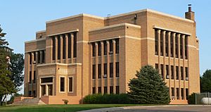
Charles Mix County Courthouse in Lake Andes
|
|

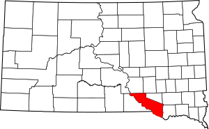
Location within the U.S. state of South Dakota
|
|
 South Dakota's location within the U.S. |
|
| Country | |
| State | |
| Founded | 1862 (created) 1879 (organized) |
| Named for | Charles Eli Mix |
| Seat | Lake Andes |
| Largest city | Wagner |
| Area | |
| • Total | 1,150 sq mi (3,000 km2) |
| • Land | 1,097 sq mi (2,840 km2) |
| • Water | 53 sq mi (140 km2) 4.6% |
| Population
(2020)
|
|
| • Total | 9,373 |
| • Estimate
(2023)
|
9,240 |
| • Density | 8.15/sq mi (3.147/km2) |
| Time zone | UTC−6 (Central) |
| • Summer (DST) | UTC−5 (CDT) |
| Congressional district | At-large |
Charles Mix County is a county located in the state of South Dakota in the United States. In 2020, about 9,373 people lived there. The main town, or county seat, is Lake Andes.
The county was first created in 1862 and officially started working in 1879. It was named after Charles Eli Mix. He was an important government official who helped sign a peace agreement with the local Lakota Indian tribes. A large part of the eastern side of the county is home to the Yankton Indian Reservation.
An old building called the Papineau Trading Post, now in Geddes, South Dakota, was one of the first places where the county government met. The Charles Mix County Courthouse in Lake Andes, where county business happens today, was built in 1918.
Contents
Geography of Charles Mix County
Charles Mix County is located on the southern border of South Dakota. Its southern edge touches the state of Nebraska. The Missouri River flows along this southern border. The land in the county has rolling hills, and most of it is used for farming.
The county covers a total area of about 1,150 square miles (2,978 square kilometers). About 1,097 square miles (2,841 square kilometers) is land, and 53 square miles (137 square kilometers) is water.
Main Roads
Neighboring Counties
- Brule County - northwest
- Aurora County - north
- Douglas County - northeast
- Hutchinson County - northeast
- Bon Homme County - east
- Knox County, Nebraska - southeast
- Boyd County, Nebraska - southwest
- Gregory County - west
Protected Natural Areas
Charles Mix County has many natural areas set aside to protect wildlife and offer outdoor fun. Some of these include:
- Academy Lake State Game Production Area
- Lake Andes National Wildlife Refuge
- Missouri National Recreational River (part)
- North Point State Recreation Area
- Platte Creek State Recreation Area
- Snake Creek State Recreation Area
There are also many other game production areas and waterfowl production areas.
Major Lakes
- Academy Lake
- Carroll Lake
- Lake Francis Case (part)
- Goose Lake
- Lake Andes
- Lake Platte
- White Lake
People in Charles Mix County
| Historical population | |||
|---|---|---|---|
| Census | Pop. | %± | |
| 1870 | 152 | — | |
| 1880 | 407 | 167.8% | |
| 1890 | 4,178 | 926.5% | |
| 1900 | 8,498 | 103.4% | |
| 1910 | 14,899 | 75.3% | |
| 1920 | 16,256 | 9.1% | |
| 1930 | 16,703 | 2.7% | |
| 1940 | 13,449 | −19.5% | |
| 1950 | 15,558 | 15.7% | |
| 1960 | 11,785 | −24.3% | |
| 1970 | 9,994 | −15.2% | |
| 1980 | 9,680 | −3.1% | |
| 1990 | 9,131 | −5.7% | |
| 2000 | 9,350 | 2.4% | |
| 2010 | 9,129 | −2.4% | |
| 2020 | 9,373 | 2.7% | |
| 2023 (est.) | 9,240 | 1.2% | |
| U.S. Decennial Census 1790-1960 1900-1990 1990-2000 2010-2020 |
|||
In 2010, there were 9,129 people living in Charles Mix County. The population density was about 8.3 people per square mile. Most people (65%) were white, and about 31.7% were American Indian. Other groups made up smaller parts of the population.
The average age of people in the county was about 38 years old. Many households had children under 18 living with them. The average income for a family was around $46,962 per year.
Towns and Communities
Charles Mix County has several towns and communities.
Reservation
Cities
- Geddes
- Lake Andes (county seat)
- Platte
- Wagner
Towns
Census-designated places
These are areas that are like towns but are not officially incorporated as cities or towns.
- Clearfield Colony
- Lakeview Colony
- Marty
- Platte Colony
Townships
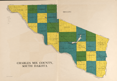
The county is also divided into many smaller areas called townships, which help manage local services.
Unorganized territory
The area known as Castalia is an unorganized territory within the county.
Famous People from Charles Mix County
- Ella Deloria, a Yankton Dakota expert on cultures
- Doug Eggers, an American football player
- Faith Spotted Eagle, the first Native American woman to receive an electoral college vote for President of the United States (in 2016).
- Jack Sully, who was elected sheriff in 1872.
See also
 In Spanish: Condado de Charles Mix para niños
 | Aurelia Browder |
 | Nannie Helen Burroughs |
 | Michelle Alexander |


