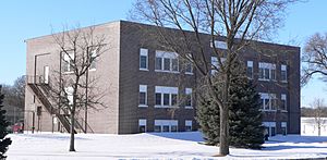
Knox County, Nebraska facts for kids
Quick facts for kids
Knox County
|
|
|---|---|

Knox County Courthouse in Center
|
|

Location within the U.S. state of Nebraska
|
|
 Nebraska's location within the U.S. |
|
| Country | |
| State | |
| Founded | 1857 |
| Named for | Henry Knox |
| Seat | Center |
| Largest city | Creighton |
| Area | |
| • Total | 1,140 sq mi (3,000 km2) |
| • Land | 1,108 sq mi (2,870 km2) |
| • Water | 31 sq mi (80 km2) 2.8%% |
| Population
(2020)
|
|
| • Total | 8,401 |
| • Estimate
(2022)
|
8,336 |
| • Density | 7.37/sq mi (2.845/km2) |
| Time zone | UTC−6 (Central) |
| • Summer (DST) | UTC−5 (CDT) |
| Congressional district | 3rd |
Knox County is a special area in the state of Nebraska, USA. It is called a county. In 2020, about 8,391 people lived there. The main town, or county seat, is Center.
Knox County got its name from Henry Knox. He was a very important Major General in the Continental Army and the United States Army. If you see a Nebraska license plate with the number 12, it means the car is from Knox County. This is because it had the 12th-largest number of registered vehicles in 1922.
Contents
History of Knox County
Knox County was officially created in 1857. At first, it had a different name: L'Eau Qui Court. This was a French name for the Niobrara River. Both "L'Eau Qui Court" and "Niobrara" mean "Running Water" in English.
The name was changed to Knox County on February 21, 1873. This new name became official on April 1, 1873.
Geography of Knox County

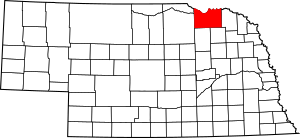
Knox County is located along the northern border of Nebraska. Its northern edge touches the state of South Dakota. The land in the county has gentle, rolling hills that slope towards the northeast. Most of the flat areas are used for farming.
The Missouri River flows east along the county's northern border. The Niobrara River enters the county from the west. It flows east and then north, joining the Missouri River near the village of Niobrara. A smaller stream, Verdigre Creek, flows north through the middle of the county. It also joins the Niobrara River.
Knox County covers a total area of about 1,140 square miles. Most of this area, about 1,108 square miles, is land. The remaining 31 square miles (about 2.8%) is water.
Main Roads in Knox County
Neighboring Counties
- Bon Homme County, South Dakota - to the north
- Yankton County, South Dakota - to the northeast
- Cedar County - to the east
- Pierce County - to the southeast
- Antelope County - to the south
- Holt County - to the west
- Boyd County - to the northwest
- Charles Mix County, South Dakota - to the northwest
Protected Natural Areas
- Bazile Creek State Wildlife Management Area
- Bloomfield Recreation Area
- Deep Water Recreation Area
- Lewis and Clark Lake (part of it)
- Lewis and Clark State Recreation Area
- Miller Creek Recreation Area
- Missouri National Recreational River (part of it)
- Niobrara State Park
- South Shore Recreation Area
Population and People
| Historical population | |||
|---|---|---|---|
| Census | Pop. | %± | |
| 1860 | 152 | — | |
| 1870 | 261 | 71.7% | |
| 1880 | 3,666 | 1,304.6% | |
| 1890 | 8,582 | 134.1% | |
| 1900 | 14,343 | 67.1% | |
| 1910 | 18,358 | 28.0% | |
| 1920 | 18,894 | 2.9% | |
| 1930 | 19,110 | 1.1% | |
| 1940 | 16,478 | −13.8% | |
| 1950 | 14,820 | −10.1% | |
| 1960 | 13,300 | −10.3% | |
| 1970 | 11,723 | −11.9% | |
| 1980 | 11,457 | −2.3% | |
| 1990 | 9,534 | −16.8% | |
| 2000 | 9,374 | −1.7% | |
| 2010 | 8,701 | −7.2% | |
| 2020 | 8,391 | −3.6% | |
| 2022 (est.) | 8,336 | −4.2% | |
| US Decennial Census 1790-1960 1900-1990 1990-2000 2010-2013 2020-2022 |
|||
In 2010, there were 8,701 people living in Knox County. These people lived in 3,647 households. About 10% of the population identified as Native American. Most of the people were White.
By 2020, the population was 8,391. The county has seen its population change over the years, as shown in the table above.
Towns and Villages
Cities
Villages
Census-Designated Place
Other Communities (Unincorporated)
Townships
- Addison
- Bohemia
- Central
- Cleveland
- Columbia
- Creighton
- Dolphin
- Dowling
- Eastern
- Frankfort
- Harrison
- Herrick
- Hill
- Jefferson
- Lincoln
- Logan
- Miller
- Morton
- Niobrara
- North Frankfort
- Peoria
- Raymond
- Spade
- Sparta
- Union
- Valley
- Verdigre
- Walnut Grove
- Washington
- Western
See also
 In Spanish: Condado de Knox (Nebraska) para niños
 | Percy Lavon Julian |
 | Katherine Johnson |
 | George Washington Carver |
 | Annie Easley |

