Niobrara, Nebraska facts for kids
Quick facts for kids
Niobrara
Ní Ubthátha (Omaha–Ponca)
|
|
|---|---|
|
Village
|
|

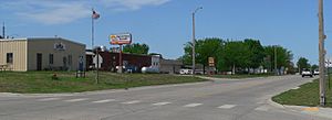
Nebraska Highway 12 in Niobrara
|
|

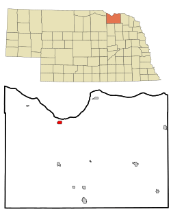
Location of Niobrara, Nebraska
|
|
| Country | United States |
| State | Nebraska |
| County | Knox |
| Area | |
| • Total | 0.73 sq mi (1.89 km2) |
| • Land | 0.73 sq mi (1.89 km2) |
| • Water | 0.00 sq mi (0.00 km2) |
| Elevation | 1,299 ft (396 m) |
| Population
(2020)
|
|
| • Total | 365 |
| • Estimate
(2021)
|
363 |
| • Density | 501.37/sq mi (193.49/km2) |
| Time zone | UTC−6 (Central (CST)) |
| • Summer (DST) | UTC−5 (CDT) |
| ZIP Code |
68760
|
| Area code(s) | 402 |
| FIPS code | 31-34370 |
| GNIS feature ID | 2399499 |
Niobrara (/ˌnaɪ.əˈbrærə/) is a small village in Knox County, Nebraska, United States. Its name comes from the Omaha words Ní Ubthátha (IPA: [nĩꜜ ubɫᶞaꜜɫᶞa tʰãꜜwãŋɡɫᶞã]), which means "water spread-out village." In 2020, the village had a population of 365 people.
Contents
History of Niobrara
Niobrara was founded in 1856. A group of men, led by Dr. Benneville Yeakel Shelly, chose this spot by the Missouri River. They built a fort there to protect the first settlers. The village was named after the nearby Niobrara River.
Geography of Niobrara
Nebraska highways 12 and 14 both pass through Niobrara. Highway 14 connects Nebraska to South Dakota using the Chief Standing Bear Memorial Bridge. This bridge is just east of the village and crosses the Missouri River.
The village covers about 0.73 square miles (1.89 square kilometers) of land. The Niobrara River flows right next to the town. However, it actually goes through the Mormon Canal instead of its original riverbed.
Population Changes in Niobrara
| Historical population | |||
|---|---|---|---|
| Census | Pop. | %± | |
| 1880 | 475 | — | |
| 1890 | 633 | 33.3% | |
| 1900 | 459 | −27.5% | |
| 1910 | 633 | 37.9% | |
| 1920 | 736 | 16.3% | |
| 1930 | 761 | 3.4% | |
| 1940 | 629 | −17.3% | |
| 1950 | 577 | −8.3% | |
| 1960 | 736 | 27.6% | |
| 1970 | 602 | −18.2% | |
| 1980 | 419 | −30.4% | |
| 1990 | 376 | −10.3% | |
| 2000 | 379 | 0.8% | |
| 2010 | 370 | −2.4% | |
| 2020 | 365 | −1.4% | |
| U.S. Decennial Census | |||
Niobrara's Population in 2010
In 2010, there were 370 people living in Niobrara. These people lived in 193 households, with 93 of them being families. The village had about 507 people per square mile.
Most of the people in Niobrara were White (84.3%). About 11.6% were Native American, and a small number were African American or from two or more races. About 2.4% of the population was Hispanic or Latino.
The average age in the village was 54.8 years old. About 16.8% of residents were under 18. About 29.2% were 65 or older. The population was almost evenly split between males (51.4%) and females (48.6%).
Climate in Niobrara
Niobrara has a type of weather called a humid continental climate. This means it has big changes in temperature throughout the year. Summers are usually warm to hot and can be humid. Winters are cold, and sometimes very cold.
| Climate data for Niobrara, Nebraska | |||||||||||||
|---|---|---|---|---|---|---|---|---|---|---|---|---|---|
| Month | Jan | Feb | Mar | Apr | May | Jun | Jul | Aug | Sep | Oct | Nov | Dec | Year |
| Mean daily maximum °C (°F) | 0 (32) |
3 (37) |
8 (47) |
17 (63) |
23 (74) |
28 (83) |
32 (89) |
31 (87) |
26 (79) |
19 (67) |
9 (48) |
2 (36) |
17 (62) |
| Mean daily minimum °C (°F) | −13 (9) |
−9 (15) |
−4 (24) |
3 (37) |
9 (48) |
14 (58) |
17 (63) |
16 (61) |
11 (51) |
4 (39) |
−4 (25) |
−9 (15) |
3 (37) |
| Average precipitation mm (inches) | 13 (0.5) |
15 (0.6) |
36 (1.4) |
61 (2.4) |
86 (3.4) |
97 (3.8) |
74 (2.9) |
66 (2.6) |
58 (2.3) |
38 (1.5) |
23 (0.9) |
10 (0.4) |
580 (22.7) |
| Source: Weatherbase | |||||||||||||
Famous People from Niobrara
- Anton Krupicka, a very fast long-distance runner.
- James Tufts, who was a temporary governor of Montana Territory a long time ago.
See also
 In Spanish: Niobrara (Nebraska) para niños
 | Mary Eliza Mahoney |
 | Susie King Taylor |
 | Ida Gray |
 | Eliza Ann Grier |

