
Lindy, Nebraska facts for kids
Quick facts for kids
Lindy, Nebraska
|
|
|---|---|

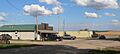
Downtown Lindy; at left is the Lindy Country Club
|
|

Lindy, Nebraska
Location in Nebraska

Lindy, Nebraska
Location in the United States
|
|
| Country | United States |
| State | Nebraska |
| County | Knox |
| Townsite surveyed | 1928 |
| Area | |
| • Total | 1.00 sq mi (2.59 km2) |
| • Land | 1.00 sq mi (2.59 km2) |
| • Water | 0.00 sq mi (0.00 km2) |
| Elevation | 1,611 ft (491 m) |
| Population
(2020)
|
|
| • Total | 13 |
| • Density | 13.03/sq mi (5.03/km2) |
| Time zone | UTC-6 (Central (CST)) |
| • Summer (DST) | UTC-5 (CDT) |
| ZIP code |
68718
|
| Area code(s) | 402 |
| FIPS code | 31-28140 |
| GNIS feature ID | 2583888 |
Lindy is a small, unincorporated community in Knox County, Nebraska, in the northeastern part of Nebraska. It is also known as a census-designated place, which means it's an area identified by the government for statistics. Lindy is located within the Santee Sioux Reservation.
As of the 2020 United States Census, only 13 people live in Lindy.
Contents
Where is Lindy Located?
Lindy is found in northeastern Knox County. It is about 7 miles (11 km) south of the Missouri River, which forms the border with South Dakota.
Nebraska Highway 12 runs along the southern edge of Lindy. This highway connects Lindy to other towns. For example, Crofton, Nebraska is about 12 miles (19 km) to the east. Niobrara, Nebraska is about 15 miles (24 km) to the west.
The Lindy area covers about 1 square mile (2.59 square kilometers) of land. It sits in the valley of Hoboe Creek. This creek flows into Howe Creek, which then flows into Bazile Creek, and finally into the Missouri River.
A Look at Lindy's Population
| Historical population | |||
|---|---|---|---|
| Census | Pop. | %± | |
| 2020 | 13 | — | |
| U.S. Decennial Census | |||
The number of people living in Lindy has changed over time.
- In 1978, the population was 38 people.
- By 2002, it had decreased to 13 residents.
- The 2020 United States Census confirmed the population remained at 13 people.
Lindy's Past: A Brief History
Lindy was established quite late in Nebraska's history. The town was officially surveyed in 1928. People wanted a local place to shop and sell their goods.
How Lindy Got Its Name
The town was named after Charles Lindbergh. He was a famous pilot nicknamed "Lucky Lindy." The year before Lindy was founded, Charles Lindbergh made a celebrated solo flight from New York to Paris.
Early Businesses and Growth
At one point, Lindy was a busy place with many businesses. These included:
- A hardware store
- A barbershop
- An ice-cream parlor
- A blacksmith shop
- An electrical-appliances shop
There was also a large building with multiple floors. It had a garage in the basement, a dance hall and movie theater on the second floor, and offices and living spaces on the third floor. However, this building was taken apart in 1944. From 1944 to 1958, the local Addison Telephone Company operated from Lindy.
Changes Over Time
Over the years, Lindy's population got smaller. Many businesses closed down. For example, the town's feed store, general store, and gas pumps closed or moved away in the late 1980s and early 1990s.
Lindy Today: What's There Now?
Even though it's a small community, Lindy still has a few important places.
- The Lindy Country Club: This is a restaurant and bar.
- Good Shepherd Evangelical Lutheran Church: The community's church.
- A fire hall: This building is used by the Bloomfield Volunteer Fire Department and Rescue Unit.
Lindy is still located on Nebraska Highway 12 and is part of the Santee Sioux Reservation.
The Shannon Trail Project
In 2001, several communities in northeastern Nebraska worked together. They formed a group called Shannon Trail Promoters. Their goal was to attract more tourists for the 200th anniversary of the Lewis and Clark Expedition.
They created thirteen wooden chainsaw sculptures of Private George Shannon. He was a member of the Lewis and Clark Expedition who got lost for 16 days in 1804. These statues were placed in towns along a 240-mile (386 km) route called the Shannon Trail.
Sixteen special markers were also put along the trail. These markers tell stories about George Shannon's journey. A statue and a marker were placed in Lindy, right next to the country club.
Images for kids
-
Downtown Lindy; at left is the Lindy Country Club
See also
 In Spanish: Lindy (Nebraska) para niños
