Gavins Point Dam facts for kids
Quick facts for kids Gavins Point Dam |
|
|---|---|

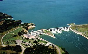
Gavins Point Dam on the Missouri River, impounding Lewis and Clark Lake.
|
|
|
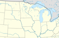
Location of Gavins Point Dam in the Midwestern United States.
|
|
| Country | United States |
| Location | Cedar County, Nebraska and Yankton County, South Dakota. |
| Coordinates | 42°50′58″N 97°28′55″W / 42.849382°N 97.482018°W |
| Status | Operational |
| Construction began | 1952 |
| Opening date | 1957 |
| Construction cost | $51 million |
| Owner(s) | |
| Dam and spillways | |
| Type of dam | Embankment, rolled-earth and chalk-fill |
| Impounds | Missouri River |
| Height | 74 ft (23 m) |
| Length | 8,700 ft (2,652 m) |
| Width (crest) | 35 ft (11 m) |
| Width (base) | 850 ft (259 m) |
| Dam volume | 7,000,000 cu yd (5,351,884 m3) |
| Reservoir | |
| Creates | Lewis and Clark Lake |
| Total capacity | 492,000 acre⋅ft (606,873,064 m3) |
| Catchment area | 279,480 sq mi (723,850 km2) |
| Surface area | 31,400 acres (12,700 ha) |
| Maximum length | 25 mi (40 km) |
| Maximum water depth | 45 ft (14 m) |
| Normal elevation | 1,210 feet msl |
| Power station | |
| Operator(s) | U.S. Army Corps of Engineers (Operator); Western Area Power Administration (marketer) |
| Commission date | 1957 |
| Turbines | 3 x 44 MW |
| Installed capacity | 132 MW |
| Annual generation | 727 million KWh |
| Website U.S. Army Corps of Engineers, Gavins Point Project |
|
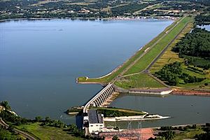
The Gavins Point Dam is a huge structure that stretches for about 1.9 miles (3 km) across the Missouri River. It's an embankment dam, meaning it's built from earth and chalk. This dam creates a large body of water called Lewis and Clark Lake. It connects Cedar County, Nebraska and Yankton County, South Dakota.
The dam and its hydroelectric power plant were built between 1952 and 1957. This project was part of a bigger plan called the Pick–Sloan Missouri Basin Program. The United States Army Corps of Engineers built and manages the dam. You can find Gavins Point Dam about 4 miles (6.4 km) west of Yankton, South Dakota.
Contents
Building the Dam: A Look Back

Gavins Point Dam was built as part of the Pick–Sloan Missouri Basin Program. This program was approved by the U.S. Congress in 1944. The dam gets its name from Gavins Point, which is a bluff (a steep cliff) along the Missouri River. This bluff was supposed to be the original spot for the dam.
However, the builders decided to move the dam's location a bit downstream. They chose a spot called Calumet Bluff. This new spot was better because it was shorter to span. This meant they needed less material to build the dam. Even though the location changed, the project kept the original name.
The Gavins Point Dam works with other dams in the Pick-Sloan Program. Together, these dams help manage the water resources in the Missouri River Basin. They help with many important things. These include controlling floods, helping boats travel, providing water for farms, and supplying water for cities and industries. They also generate power, help clean the river, protect fish and wildlife, and create fun places for recreation. Gavins Point is the last dam on the Missouri River before it joins the Mississippi River. The dam just upstream from it is called Fort Randall Dam.
The Big Flood of 2011
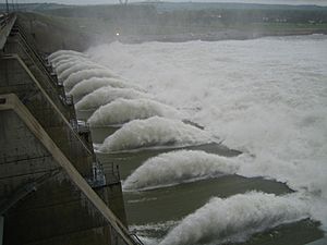
In 2011, the 2011 Missouri River Flood caused a huge amount of water to flow through the dam. The dam released a record 160,200 cubic feet per second (cfs) of water. The old record, set in 1997, was only 70,000 cfs.
During this flood, the dam was damaged. Debris hit it, and many rocks were knocked loose from its upstream side. The U.S. Army Corps of Engineers quickly started fixing the dam and its spillway gates. They also added special sensors to the concrete parts of the dam to monitor pressure.
Making Electricity: Hydroelectric Power
The Gavins Point Dam has a hydroelectric power plant. This plant has three large generators. Each generator can produce 44,099 kilowatts (kW) of power. This means the plant can make a total of 132.297 megawatts (MW) of electricity.
This power plant creates enough electricity to supply about 68,000 homes! The electricity generated here is sold through an organization called the Western Area Power Administration.
Lewis and Clark Lake: The Reservoir
See main article: Lewis and Clark Lake

The Gavins Point Dam creates Lewis and Clark Lake. This lake is a very popular spot for tourists and locals. People come here for many water activities like boating and fishing. There are also opportunities for camping, hiking, and hunting nearby. These activities are managed by the states of South Dakota and Nebraska, along with the U.S. Army Corps of Engineers.
However, the lake faces a big problem called sedimentation. This means that sediment (like sand and mud) carried by the Missouri River and Niobrara River settles in the lake. The dam stops the natural flow of the river, which causes the sediment to build up.
Studies show that about 5.1 million tons of sediment are deposited in the lake every year. This causes the lake's surface area to shrink and its ability to store water to lessen. About 60% of this sediment comes from the Nebraska Sandhills through the Niobrara River. As of 2016, about 30% of the lake's surface area had already disappeared due to this sediment. Some experts believe that by 2045, half of the lake could be gone. Right now, there isn't a clear plan to stop or remove this buildup of silt in the lake.
 | Bessie Coleman |
 | Spann Watson |
 | Jill E. Brown |
 | Sherman W. White |


