Cedar County, Nebraska facts for kids
Quick facts for kids
Cedar County
|
|
|---|---|

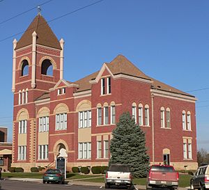
Cedar County Courthouse in Hartington
|
|

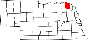
Location within the U.S. state of Nebraska
|
|
 Nebraska's location within the U.S. |
|
| Country | |
| State | |
| Founded | 1857 |
| Seat | Hartington |
| Largest city | Hartington |
| Area | |
| • Total | 746 sq mi (1,930 km2) |
| • Land | 740 sq mi (1,900 km2) |
| • Water | 5.5 sq mi (14 km2) 0.7%% |
| Population
(2020)
|
|
| • Total | 8,380 |
| • Density | 11.233/sq mi (4.337/km2) |
| Time zone | UTC−6 (Central) |
| • Summer (DST) | UTC−5 (CDT) |
| Congressional district | 3rd |
Cedar County is a special area in the state of Nebraska, USA. It's like a big neighborhood with its own local government. In 2020, about 8,380 people lived here. The main town, or county seat, is Hartington.
Cedar County was created in 1857. It got its name from the many cedar trees that grew in the area. If you look at a Nebraska license plate, cars from Cedar County have the number 13. This is because it had the 13th highest number of registered cars when the system started in 1922.
Contents
Where is Cedar County?

Cedar County is located in the northern part of Nebraska. Its northern border is right next to South Dakota, with the Missouri River flowing between them.
The county covers about 746 square miles. Most of this (740 square miles) is land, and a small part (5.5 square miles) is water.
Main Roads
You can travel through Cedar County on several important roads:
 U.S. Highway 20
 U.S. Highway 81
 Nebraska Highway 12
 Nebraska Highway 15
 Nebraska Highway 57
 Nebraska Highway 59
 Nebraska Highway 84
 Nebraska Highway 121
Neighboring Counties
Cedar County shares its borders with these other counties:
- Clay County, South Dakota - to the northeast
- Dixon County - to the east
- Wayne County - to the southeast
- Pierce County - to the southwest
- Knox County - to the west
- Yankton County, South Dakota - to the northwest
Nature Spots
Cedar County has many beautiful places where you can enjoy nature:
- Audubon Bend Wildlife Area
- Calumet Bluff
- Chalkrock State Wildlife Management Area
- Cottonwood Recreation Area
- Missouri National Recreational River (part of it)
- Bow Creek Recreation Area
- Meridian Bridge
- Nebraska Tailwaters Recreation Area
- Tatanka State Wildlife Management Area (part of it)
- Training Dike Recreation Area
- Wiseman State Wildlife Management Area
Lakes
- Chalkrock Lake
- Lewis and Clark Lake (part of it)
Who Lives Here?
| Historical population | |||
|---|---|---|---|
| Census | Pop. | %± | |
| 1860 | 246 | — | |
| 1870 | 1,032 | 319.5% | |
| 1880 | 2,899 | 180.9% | |
| 1890 | 7,028 | 142.4% | |
| 1900 | 12,467 | 77.4% | |
| 1910 | 15,191 | 21.8% | |
| 1920 | 16,225 | 6.8% | |
| 1930 | 16,427 | 1.2% | |
| 1940 | 15,126 | −7.9% | |
| 1950 | 13,843 | −8.5% | |
| 1960 | 13,368 | −3.4% | |
| 1970 | 12,192 | −8.8% | |
| 1980 | 11,375 | −6.7% | |
| 1990 | 10,131 | −10.9% | |
| 2000 | 9,615 | −5.1% | |
| 2010 | 8,852 | −7.9% | |
| 2020 | 8,380 | −5.3% | |
| 2022 (est.) | 8,371 | −5.4% | |
| US Decennial Census 1790-1960 1900-1990 1990-2000 2010 2020 |
|||
Over the years, the number of people living in Cedar County has changed. In 1860, there were only 246 people. The population grew a lot until the 1930s. Since then, it has slowly decreased.
In 2000, there were 9,615 people living in the county. About 3,623 homes were counted. Many families lived there, with 63.6% being married couples. About 34.8% of homes had children under 18.
The average age of people in Cedar County in 2000 was 39 years old. About 29.4% of the population was under 18.
Towns and Villages
Cedar County has several communities where people live and work.
Cities
- Hartington (This is the county seat, the main town)
- Laurel
- Randolph
Villages
These are smaller towns:
Other Communities
- Aten (a census-designated place)
- Bow Valley (a census-designated place)
Small Settlements
These are even smaller places that are not officially cities or villages:
See also
 In Spanish: Condado de Cedar (Nebraska) para niños
 | Laphonza Butler |
 | Daisy Bates |
 | Elizabeth Piper Ensley |

