
Wayne County, Nebraska facts for kids
Quick facts for kids
Wayne County
|
|
|---|---|
_from_SE_1.JPG)
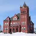
Wayne County Courthouse in Wayne
|
|

Location within the U.S. state of Nebraska
|
|
 Nebraska's location within the U.S. |
|
| Country | |
| State | |
| Founded | 1870 |
| Named for | Anthony Wayne |
| Seat | Wayne |
| Largest city | Wayne |
| Area | |
| • Total | 443 sq mi (1,150 km2) |
| • Land | 443 sq mi (1,150 km2) |
| • Water | 0.4 sq mi (1 km2) 0.09%% |
| Population
(2020)
|
|
| • Total | 9,697 |
| • Density | 21.889/sq mi (8.452/km2) |
| Time zone | UTC−6 (Central) |
| • Summer (DST) | UTC−5 (CDT) |
| Congressional district | 3rd |
Wayne County is a special area in the U.S. state of Nebraska. It's called a county. In 2020, about 9,697 people lived here. The main town, or county seat, is Wayne.
When you see a Nebraska license plate, Wayne County cars have the number 27. This is because it had the 27th most registered vehicles in the state back in 1922.
Contents
History of Wayne County
Wayne County was officially created in the fall of 1870. This happened by a special announcement from Governor David Butler. As more people moved in, the county was divided into smaller areas called precincts.
These precincts were named after important people, early settlers, or even local creeks. Today, Wayne County has 13 of these precincts. Both Wayne County and the city of Wayne are named after Anthony Wayne. He was a famous general during the American Revolutionary War.
Geography and Nature
Wayne County has gently rolling hills. Most of the land is used for farming. The ground slopes slightly down towards the east and northeast. A small stream called South Logan Creek flows through the middle of the county.
The county covers a total area of 443 square miles. Almost all of this is land, with only a tiny bit (0.4 square miles) being water.
Main Roads in Wayne County
 Nebraska Highway 15
 Nebraska Highway 16
 Nebraska Highway 35
 Nebraska Highway 57
 Nebraska Highway 98
Neighboring Counties
Wayne County shares its borders with several other counties:
- Dixon County – to the northeast
- Thurston County – to the east
- Cuming County – to the southeast
- Stanton County – to the south
- Madison County – to the southwest
- Pierce County – to the west
- Cedar County – to the north
Protected Natural Areas
- Sioux Strip State Wildlife Management Area is a special place in the county. It helps protect local wildlife and their homes.
Population Over Time
| Historical population | |||
|---|---|---|---|
| Census | Pop. | %± | |
| 1870 | 182 | — | |
| 1880 | 813 | 346.7% | |
| 1890 | 6,189 | 661.3% | |
| 1900 | 9,862 | 59.3% | |
| 1910 | 10,397 | 5.4% | |
| 1920 | 9,725 | −6.5% | |
| 1930 | 10,566 | 8.6% | |
| 1940 | 9,880 | −6.5% | |
| 1950 | 10,129 | 2.5% | |
| 1960 | 9,959 | −1.7% | |
| 1970 | 10,400 | 4.4% | |
| 1980 | 9,858 | −5.2% | |
| 1990 | 9,364 | −5.0% | |
| 2000 | 9,851 | 5.2% | |
| 2010 | 9,595 | −2.6% | |
| 2020 | 9,697 | 1.1% | |
| 2022 (est.) | 9,871 | 2.9% | |
| US Decennial Census 1790-1960 1900-1990 1990-2000 2010 2020 2022 |
|||
In 2000, there were 9,851 people living in Wayne County. Most people (96.78%) were White. About 1.48% of the population identified as Hispanic or Latino. Many families in the county have German, Irish, or Swedish backgrounds.
The average age of people in Wayne County in 2000 was 28 years old. About 21.60% of the population was under 18 years old.
Towns and Villages
Wayne County has several communities where people live.
Cities
Villages
Unincorporated Community
Some towns that existed long ago in Wayne County are no longer there. For example, LaPorte once had nearly 300 people. It even had a temporary courthouse. But then the railroad chose a different path, and the town faded away. Other towns like Taffe, Logan City, Apex, Melvin, Weber, and Spring Branch also no longer exist.
Precincts of Wayne County
Wayne County is divided into 13 smaller areas called precincts. These areas were named after important people, early settlers, or local creeks.
- Brenna - Named for the sister of F.E. Moses, who was the first settler in that area.
- Chapin - Named after an early settler, Arthur T. Chapin.
- Deer Creek - Named because deer horns were found on the prairies there long ago.
- Garfield - Named after US President James A. Garfield.
- Hancock - Named after Civil War General Winfield Scott Hancock.
- Hoskins - First called Spring Branch. Later named for Mr. Hoskins, who worked for the company that planned the village of Hoskins.
- Hunter - Named for early settler Cyrus E. Hunter, who came from Illinois.
- Logan - Likely named for John A. Logan, a political candidate.
- Leslie - Could be named for an early judge or a post office.
- Plum Creek - Named for the wild plum trees seen along the creek in early days.
- Sherman - Named for a Civil War General.
- Strahan - Named for J.M. Strahan, an early settler.
- Wilbur - Named for Russell H. Wilbur, a pioneer in the precinct.
Schools in Wayne County
Children in Wayne County attend schools in various districts. Here are some of the school districts:
- Laurel-Concord-Coleridge School
- Norfolk Public Schools
- Pender Public Schools
- Pierce Public Schools
- Randolph Public Schools
- Wakefield Public Schools
- Wayne Community Schools
- Winside Public Schools
- Wisner-Pilger Public Schools
Images for kids
-
Wayne County Courthouse in Wayne
See also
 In Spanish: Condado de Wayne (Nebraska) para niños
