Wakefield, Nebraska facts for kids
Quick facts for kids
Wakefield, Nebraska
|
|
|---|---|

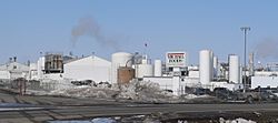
Michael Foods egg-processing plant in Wakefield, March 2010
|
|

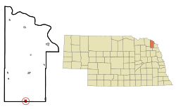
Location of Wakefield, Nebraska
|
|
| Country | United States |
| State | Nebraska |
| Counties | Dixon, Wayne |
| Area | |
| • Total | 1.13 sq mi (2.93 km2) |
| • Land | 1.06 sq mi (2.75 km2) |
| • Water | 0.07 sq mi (0.18 km2) |
| Elevation | 1,391 ft (424 m) |
| Population
(2020)
|
|
| • Total | 1,522 |
| • Density | 1,433.15/sq mi (553.13/km2) |
| Time zone | UTC-6 (Central (CST)) |
| • Summer (DST) | UTC-5 (CDT) |
| ZIP code |
68784
|
| Area code(s) | 402 |
| FIPS code | 31-51070 |
| GNIS feature ID | 2397168 |
Wakefield is a city in the state of Nebraska, United States. It is located in both Dixon County and Wayne County. In 2010, the city had a population of 1,451 people. The part of Wakefield in Dixon County is also considered part of the larger Sioux City metropolitan area.
Contents
History of Wakefield
Wakefield began in 1881. This was after the Chicago, St. Paul, Minneapolis and Omaha Railway built its tracks through the area. The city was named after L. W. Wakefield, who was a railroad engineer. Wakefield officially became a city in 1883.
Population and People
This section looks at how many people live in Wakefield and how the population has changed over time.
Population Growth Over Time
The number of people living in Wakefield has changed quite a bit since 1900. Here's a quick look at the population counts from different years:
| Historical population | |||
|---|---|---|---|
| Census | Pop. | %± | |
| 1900 | 755 | — | |
| 1910 | 861 | 14.0% | |
| 1920 | 1,114 | 29.4% | |
| 1930 | 1,112 | −0.2% | |
| 1940 | 961 | −13.6% | |
| 1950 | 1,027 | 6.9% | |
| 1960 | 1,068 | 4.0% | |
| 1970 | 1,160 | 8.6% | |
| 1980 | 1,125 | −3.0% | |
| 1990 | 1,082 | −3.8% | |
| 2000 | 1,411 | 30.4% | |
| 2010 | 1,451 | 2.8% | |
| 2020 | 1,522 | 4.9% | |
| U.S. Decennial Census | |||
What the 2010 Census Showed
In 2010, there were 1,451 people living in Wakefield. These people lived in 534 households. A household is a group of people living together in one home. About 352 of these households were families.
The city had 575 housing units in total. A housing unit is a house, apartment, or other place where people live. The average household had about 2.64 people. The average family had about 3.23 people.
About 25.7% of the people in Wakefield were under 18 years old. About 18.5% were 65 years old or older. The average age in the city was 38 years.
Wakefield's Economy
The economy of Wakefield is supported by several important businesses. These businesses provide jobs for many people in the city.
The biggest employer in Wakefield is the Michael Foods egg-processing plant. This plant employs about 800 people. It plays a very important role in the local economy.
Other major employers include the Wakefield Health Care Center. This is a nursing home that employs 65 people. Wakefield Public School also employs 55 people. Central Valley Ag is a company that supplies fertilizer and farm supplies. It has 20 employees. Roses Transport is a company that hauls freight. It employs 17 people.
Geography and Climate
This section describes where Wakefield is located and what its weather is like.
Where is Wakefield Located?
According to the United States Census Bureau, Wakefield covers a total area of about 0.94 square miles (2.43 square kilometers). Most of this area, about 0.87 square miles (2.25 square kilometers), is land. The remaining 0.07 square miles (0.18 square kilometers) is water.
Wakefield's Climate and Weather
Wakefield experiences a wide range of temperatures throughout the year. Summers are generally warm, while winters can be very cold. The city also gets a good amount of rain and snow.
The hottest month is usually July, with average high temperatures around 86.3°F (30.2°C). The coldest month is January, with average low temperatures around 9.5°F (-12.5°C). The highest temperature ever recorded was 115°F (46°C). The lowest temperature ever recorded was -41°F (-41°C).
Wakefield receives about 30.69 inches (779.5 mm) of precipitation each year. Most of this falls as rain, but there is also significant snowfall, especially in winter. The average annual snowfall is about 35.5 inches (90.2 cm).
| Climate data for Wakefield, Nebraska (1991−2020 normals, extremes 1897−present) | |||||||||||||
|---|---|---|---|---|---|---|---|---|---|---|---|---|---|
| Month | Jan | Feb | Mar | Apr | May | Jun | Jul | Aug | Sep | Oct | Nov | Dec | Year |
| Record high °F (°C) | 73 (23) |
73 (23) |
89 (32) |
101 (38) |
109 (43) |
108 (42) |
115 (46) |
110 (43) |
103 (39) |
96 (36) |
83 (28) |
72 (22) |
115 (46) |
| Mean maximum °F (°C) | 53.9 (12.2) |
58.8 (14.9) |
73.9 (23.3) |
83.3 (28.5) |
90.7 (32.6) |
95.2 (35.1) |
95.7 (35.4) |
93.9 (34.4) |
90.9 (32.7) |
85.6 (29.8) |
70.7 (21.5) |
55.2 (12.9) |
98.3 (36.8) |
| Mean daily maximum °F (°C) | 31.7 (−0.2) |
36.9 (2.7) |
49.8 (9.9) |
62.8 (17.1) |
73.3 (22.9) |
83.0 (28.3) |
86.3 (30.2) |
84.1 (28.9) |
78.3 (25.7) |
65.1 (18.4) |
48.2 (9.0) |
35.1 (1.7) |
61.2 (16.2) |
| Daily mean °F (°C) | 20.6 (−6.3) |
25.3 (−3.7) |
36.7 (2.6) |
48.5 (9.2) |
59.7 (15.4) |
70.0 (21.1) |
73.4 (23.0) |
71.3 (21.8) |
63.9 (17.7) |
51.1 (10.6) |
35.9 (2.2) |
24.3 (−4.3) |
48.4 (9.1) |
| Mean daily minimum °F (°C) | 9.5 (−12.5) |
13.7 (−10.2) |
23.7 (−4.6) |
34.2 (1.2) |
46.1 (7.8) |
57.1 (13.9) |
60.6 (15.9) |
58.5 (14.7) |
49.6 (9.8) |
37.2 (2.9) |
23.5 (−4.7) |
13.6 (−10.2) |
35.6 (2.0) |
| Mean minimum °F (°C) | −13.6 (−25.3) |
−8.0 (−22.2) |
2.8 (−16.2) |
18.2 (−7.7) |
31.9 (−0.1) |
45.9 (7.7) |
50.5 (10.3) |
48.2 (9.0) |
33.6 (0.9) |
19.1 (−7.2) |
4.7 (−15.2) |
−7.2 (−21.8) |
−17.6 (−27.6) |
| Record low °F (°C) | −41 (−41) |
−38 (−39) |
−22 (−30) |
−4 (−20) |
19 (−7) |
32 (0) |
40 (4) |
33 (1) |
17 (−8) |
0 (−18) |
−18 (−28) |
−28 (−33) |
−41 (−41) |
| Average precipitation inches (mm) | 0.74 (19) |
0.95 (24) |
1.67 (42) |
3.33 (85) |
4.12 (105) |
5.03 (128) |
3.13 (80) |
3.72 (94) |
3.01 (76) |
2.50 (64) |
1.40 (36) |
1.09 (28) |
30.69 (780) |
| Average snowfall inches (cm) | 6.9 (18) |
8.1 (21) |
5.6 (14) |
2.8 (7.1) |
0.0 (0.0) |
0.0 (0.0) |
0.0 (0.0) |
0.0 (0.0) |
0.0 (0.0) |
0.6 (1.5) |
3.6 (9.1) |
7.9 (20) |
35.5 (90) |
| Average precipitation days (≥ 0.01 in) | 5.5 | 5.4 | 6.7 | 9.8 | 11.8 | 10.5 | 9.4 | 9.3 | 7.6 | 7.2 | 5.3 | 5.7 | 94.2 |
| Average snowy days (≥ 0.1 in) | 4.9 | 4.7 | 2.8 | 1.5 | 0.0 | 0.0 | 0.0 | 0.0 | 0.0 | 0.6 | 2.0 | 4.7 | 21.2 |
| Source: NOAA | |||||||||||||
See also
 In Spanish: Wakefield (Nebraska) para niños
 | Frances Mary Albrier |
 | Whitney Young |
 | Muhammad Ali |

