Pierce County, Nebraska facts for kids
Quick facts for kids
Pierce County
|
|
|---|---|

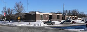
Pierce County courthouse in Pierce
|
|

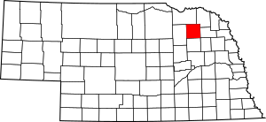
Location within the U.S. state of Nebraska
|
|
 Nebraska's location within the U.S. |
|
| Country | |
| State | |
| Founded | 1859 |
| Named for | Franklin Pierce |
| Seat | Pierce |
| Largest city | Pierce |
| Area | |
| • Total | 575 sq mi (1,490 km2) |
| • Land | 573 sq mi (1,480 km2) |
| • Water | 1.3 sq mi (3 km2) 0.2%% |
| Population
(2020)
|
|
| • Total | 7,317 |
| • Estimate
(2022)
|
7,332 |
| • Density | 12.725/sq mi (4.913/km2) |
| Time zone | UTC−6 (Central) |
| • Summer (DST) | UTC−5 (CDT) |
| Congressional district | 3rd |
Pierce County is a county located in the state of Nebraska in the United States. It's like a special area within the state. In 2020, about 7,317 people lived here. The main town, or county seat, is called Pierce.
The county was created in 1859. It was named after Franklin Pierce, who was a US President. Pierce County is also part of a larger area called the Norfolk Micropolitan Statistical Area. If you look at Nebraska license plates, cars from Pierce County have the number 40. This is because it was the 40th county with the most registered vehicles back in 1922.
Contents
History
Some of the first people to settle in Pierce County were German Lutheran families. They came from a place called Ixonia, Wisconsin. These settlers also helped start the nearby town of Norfolk.
Geography
Pierce County has gentle, rolling hills. These hills slope downwards towards the east and southeast. The north fork of the Elkhorn River flows through the middle of the county. Another stream, Dry Fork, drains the western part and flows into the Elkhorn River.
Most of the land in Pierce County is used for farming. Farmers often use a special watering system called central pivot irrigation.
The county covers a total area of about 575 square miles (1,490 square kilometers). Most of this area, about 573 square miles (1,480 square kilometers), is land. Only a small part, about 1.3 square miles (3.4 square kilometers), is water.
Major Highways
These are the main roads that go through Pierce County:
 U.S. Highway 20
 U.S. Highway 81
 Nebraska Highway 13
 Nebraska Highway 98
 Nebraska Highway 121
Neighboring Counties
Pierce County shares its borders with these other counties:
- Cedar County – to the northeast
- Wayne County – to the east
- Stanton County – to the southeast
- Madison County – to the south
- Antelope County – to the west
- Knox County – to the north
Special Areas
- Willow Creek Recreation Area is a protected natural space in the county.
Population Information
The population of Pierce County has changed over many years. Here's a look at how many people have lived there during different census counts:
| Historical population | |||
|---|---|---|---|
| Census | Pop. | %± | |
| 1870 | 152 | — | |
| 1880 | 1,202 | 690.8% | |
| 1890 | 4,864 | 304.7% | |
| 1900 | 8,445 | 73.6% | |
| 1910 | 10,122 | 19.9% | |
| 1920 | 10,681 | 5.5% | |
| 1930 | 11,080 | 3.7% | |
| 1940 | 10,211 | −7.8% | |
| 1950 | 9,405 | −7.9% | |
| 1960 | 8,722 | −7.3% | |
| 1970 | 8,493 | −2.6% | |
| 1980 | 8,481 | −0.1% | |
| 1990 | 7,827 | −7.7% | |
| 2000 | 7,857 | 0.4% | |
| 2010 | 7,266 | −7.5% | |
| 2020 | 7,317 | 0.7% | |
| 2022 (est.) | 7,332 | 0.9% | |
| US Decennial Census 1790-1960 1900-1990 1990-2000 2010 2020 2022 |
|||
In 2000, there were 7,857 people living in the county. The average age of people in Pierce County was 38 years old. About 29% of the population was under 18 years old.
Communities
Pierce County has several towns and villages.
Cities
Villages
Other Communities
These are smaller places that are not officially cities or villages:
See also
 In Spanish: Condado de Pierce (Nebraska) para niños
 | Victor J. Glover |
 | Yvonne Cagle |
 | Jeanette Epps |
 | Bernard A. Harris Jr. |

