
U.S. Route 81 facts for kids
Quick facts for kids
|
|
|---|---|
 |
|
| Route information | |
| Length | 1,220 mi (1,963 km) |
| Existed | 1926, truncated to Fort Worth in the 1990s–present |
| Major junctions | |
| South end | |
|
|
| North end | |
| Location | |
| States: | Texas, Oklahoma, Kansas, Nebraska, South Dakota, North Dakota |
| Highway system | |
| United States Numbered Highways List • Bannered • Divided • Replaced |
|

U.S. Route 81 (or US 81) is a very long road in the central United States. It runs for about 1,220 miles (1,963 kilometers) from south to north. This highway was one of the first United States Numbered Highways. These special roads were created in 1926 by a group called the American Association of State Highway Officials.
A Road with History
US 81 follows the path of an even older road called the Meridian Highway. This older road was first planned way back in 1911. In Oklahoma, US 81 also goes along the famous Chisholm Trail. This trail was used in the 1860s and 1870s for cattle drives. Cowboys would move large groups of cattle from Texas all the way to Kansas. In Kansas, the cattle could be loaded onto trains.
Where Does US 81 Go?
Today, the northern end of US 81 is near Pembina, North Dakota. This is right at the border with Canada.
The southern end of US 81 is in Fort Worth, Texas. It meets with I-35W and US 287 there.
Changes Over Time
When US 81 was first made in 1926, it went all the way to the Mexican border in Laredo, Texas. But in 1991, its southern end was moved to San Antonio. Later, it was shortened again to its current end in Fort Worth.
Images for kids
-
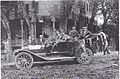
1912 Meridian Highway Inspection team in Concordia, Kansas

