Stanton County, Nebraska facts for kids
Quick facts for kids
Stanton County
|
|
|---|---|

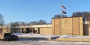
Stanton County courthouse in Stanton
|
|

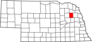
Location within the U.S. state of Nebraska
|
|
 Nebraska's location within the U.S. |
|
| Country | |
| State | |
| Founded | 1856 (founded as "Izard County") 1862 (renamed "Stanton County") 1867 (organized) |
| Named for | Edwin M. Stanton |
| Seat | Stanton |
| Largest city | Stanton |
| Area | |
| • Total | 431 sq mi (1,120 km2) |
| • Land | 428 sq mi (1,110 km2) |
| • Water | 3.1 sq mi (8 km2) 0.7%% |
| Population
(2020)
|
|
| • Total | 5,842 |
| • Density | 13.555/sq mi (5.233/km2) |
| Time zone | UTC−6 (Central) |
| • Summer (DST) | UTC−5 (CDT) |
| Congressional district | 1st |
Stanton County is a place in Nebraska, a state in the United States. In 2020, about 5,842 people lived there. Its main town, called the county seat, is Stanton.
Stanton County was created in 1856 and officially set up in 1867. First, it was called Izard County. In 1862, it was renamed after Edwin M. Stanton. He was an important person who worked for President Abraham Lincoln.
Stanton County is part of the Norfolk area. This area is known as a Micropolitan Statistical Area.
If you look at Nebraska license plates, Stanton County has the number 53. This is because it had the 53rd highest number of registered vehicles in 1922.
Contents
About the Land
Stanton County has gentle, rolling hills that slope towards the east. The Elkhorn River flows through the middle of the county.
The county covers a total area of 431 square miles. Most of this, 428 square miles, is land. Only 3.1 square miles, or 0.7%, is water.
Main Roads
Neighboring Counties
- Cuming County – to the east
- Colfax County – to the south
- Platte County – to the southwest
- Madison County – to the west
- Pierce County – to the northwest
- Wayne County – to the north
Nature Areas
- Black Island State Wildlife Management Area (part of it)
- Maskenthine Lake Recreation Area
- Red Fox State Wildlife Management Area
- Wood Duck State Wildlife Management Area
People of Stanton County
| Historical population | |||
|---|---|---|---|
| Census | Pop. | %± | |
| 1870 | 636 | — | |
| 1880 | 1,813 | 185.1% | |
| 1890 | 4,619 | 154.8% | |
| 1900 | 6,959 | 50.7% | |
| 1910 | 7,542 | 8.4% | |
| 1920 | 7,756 | 2.8% | |
| 1930 | 7,809 | 0.7% | |
| 1940 | 6,887 | −11.8% | |
| 1950 | 6,387 | −7.3% | |
| 1960 | 5,783 | −9.5% | |
| 1970 | 5,758 | −0.4% | |
| 1980 | 6,549 | 13.7% | |
| 1990 | 6,244 | −4.7% | |
| 2000 | 6,455 | 3.4% | |
| 2010 | 6,129 | −5.1% | |
| 2020 | 5,842 | −4.7% | |
| US Decennial Census 1790-1960 1900-1990 1990-2000 2010 |
|||
In 2000, there were 6,455 people living in Stanton County. The population density was about 15 people per square mile. Most people in the county were White. Some people were also of German, Czech, and Irish backgrounds.
About 38.9% of households had children under 18 living with them. The average household had about 2.76 people. The average family had about 3.16 people.
The county's population included many young people. About 29.8% were under 18 years old. About 13.5% were 65 years or older. The average age in the county was 36 years.
Towns and Villages
City
- Stanton (This is the county seat, the main town.)
Village
Census-designated place
- Woodland Park
See also
 In Spanish: Condado de Stanton (Nebraska) para niños
 | Misty Copeland |
 | Raven Wilkinson |
 | Debra Austin |
 | Aesha Ash |

