Norfolk, Nebraska facts for kids
Quick facts for kids
Norfolk, Nebraska
|
|
|---|---|

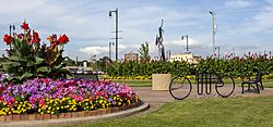
Downtown Norfolk
|
|

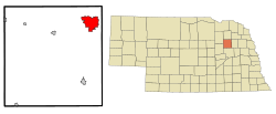
Location in Madison County and the state of Nebraska
|
|
| Country | United States |
| State | Nebraska |
| County | Madison |
| Founded | 1866 |
| Area | |
| • Total | 18.37 sq mi (47.58 km2) |
| • Land | 17.98 sq mi (46.56 km2) |
| • Water | 0.39 sq mi (1.02 km2) |
| Elevation | 1,532 ft (467 m) |
| Population
(2020)
|
|
| • Total | 24,955 |
| • Density | 1,388.16/sq mi (535.97/km2) |
| Time zone | UTC-6 (CST) |
| • Summer (DST) | UTC-5 (CDT) |
| ZIP codes |
68701-68702
|
| Area code(s) | 402 |
| FIPS code | 31-34615 |
| GNIS feature ID | 2395248 |
Norfolk is a city in Madison County, Nebraska. It is located about 113 miles northwest of Omaha. The city is also 76 miles southwest of Sioux City, Iowa. You can find it where U.S. Routes 81 and 275 meet.
In 2020, Norfolk had a population of 24,955 people. This makes it the seventh-largest city in Nebraska. It is the main city in the Norfolk Micropolitan Statistical Area. A micropolitan area is a city and its surrounding areas that are closely linked economically.
Contents
History of Norfolk
How Norfolk Was Settled
In late 1865, three scouts from a German Lutheran settlement in Wisconsin went looking for good farmland. They wanted land that was cheap and available under the Homestead Act. This act allowed people to claim land if they lived on it and farmed it.
The scouts traveled along the Elkhorn River. They found a good spot on September 15, 1865. This was where the Elkhorn River met its North Fork. On May 23, 1866, 124 settlers from Wisconsin set out for this new site. They arrived on July 15, 1866. Another group of settlers came in July 1867.
The first name for the settlement was "North Fork" or something similar. When the name was sent to postal authorities, it changed to "Norfolk." Many people in Nebraska still say "Norfork."
Norfolk was chosen as the county seat in 1867. The county seat is the main town where the county government is located. However, in 1875, after a few elections, Madison became the county seat instead.
Railroads Bring Growth
Railroads were very important for Norfolk's growth. The Fremont, Elkhorn and Missouri Valley Railroad reached Norfolk in 1879. This connected the city to other places like Blair on the Missouri River.
Another railroad, the Omaha, Niobrara, and Black Hills branch of the Union Pacific, arrived in 1880. The Chicago, St. Paul, Minneapolis & Omaha Railroad was finished in Norfolk by 1882.
These railway connections helped Norfolk grow a lot. By 1886, Norfolk's population reached 1,000. This made it a "city of the second class." In 1887, the city got a streetcar system and a public water supply. The next year, the Norfolk Electric Light Company started, and a telephone company began service.
In 1885, the state of Nebraska created a hospital in Norfolk. It was called the Insane Asylum and took its first patients in 1888. Later, its name changed to the Norfolk State Hospital in 1920. In 1962, it became the Norfolk Regional Center.
The Age of Automobiles and Air Travel
By 1900, Norfolk's population was 3,883. By 1910, it had grown to over 6,000 people. This was about one-third of Madison County's total population. In 1915, there was an attempt to move the county seat back to Norfolk, but it did not pass.
In the 1910s, the Meridian Highway was developed. This was a major north-south road across the United States. It ran right through Norfolk. In 1924, the Meridian Bridge was built over the Missouri River. This made the highway a continuous route all year. In 1926, it became U.S. Highway 81.
Another federal highway, U.S. Highway 275, was named in 1939. It follows the Elkhorn valley through Norfolk. During World War II, the part of this highway from Norfolk to O'Neill was very important. It was part of the "Strategic Network of Highways." This meant it received special funding for maintenance and materials.
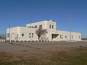
Air travel also began in Norfolk. A flying school was set up in 1928. The school's airfield grew and improved over time. In 1942, the WPA started building a municipal airport there. Even during World War II, Norfolk's airport got special attention. It served as an auxiliary field for war-related airports. After the war, Norfolk's congressman, Karl Stefan, helped get more money for the airport. Commercial passenger flights started in the early 1950s.
In the 1970s, there was another try to move the county seat to Norfolk. In a 1975 election, the idea did not get enough votes to pass.
Geography of Norfolk
Norfolk is located at 42°1′42″N 97°26′01″W / 42.02833°N 97.43361°W.
The United States Census Bureau says the city covers about 10.78 square miles (27.92 km2). Most of this area, about 10.69 square miles (27.69 km2), is land. Only a small part, about 0.09 square miles (0.23 km2), is water.
Population Information
| Historical population | |||
|---|---|---|---|
| Census | Pop. | %± | |
| 1880 | 547 | — | |
| 1890 | 3,038 | 455.4% | |
| 1900 | 3,883 | 27.8% | |
| 1910 | 6,025 | 55.2% | |
| 1920 | 8,634 | 43.3% | |
| 1930 | 10,717 | 24.1% | |
| 1940 | 10,490 | −2.1% | |
| 1950 | 11,335 | 8.1% | |
| 1960 | 13,111 | 15.7% | |
| 1970 | 16,607 | 26.7% | |
| 1980 | 19,449 | 17.1% | |
| 1990 | 21,476 | 10.4% | |
| 2000 | 23,516 | 9.5% | |
| 2010 | 24,210 | 3.0% | |
| 2020 | 24,955 | 3.1% | |
| U.S. Decennial Census | |||
2020 Census Details
The 2020 United States census counted 24,955 people living in Norfolk. There were 10,240 households and 5,724 families. The city had about 1,388 people per square mile (536.0/km2).
Most of the people were white (80.34%). Other groups included Black or African-American (1.52%), Native American (1.82%), and Asian (1.13%). About 14.0% of the population was Hispanic or Latino.
About 26.4% of households had children under 18. The average household had 2.3 people. The average family had 3.1 people.
The median age in Norfolk was 35.6 years. About 24.8% of the population was under 18. About 14.8% were 65 years or older.
The median income for a household was $49,280. The median income for a family was $68,608. About 16.0% of the population lived below the poverty line. This included 18.9% of those under 18.
2010 Census Details
In 2010, there were 24,210 people in Norfolk. There were 9,910 households and 6,005 families. The population density was about 2,265 people per square mile (875/km2).
The racial makeup was mostly White (88.0%). Hispanic or Latino people made up 12.1% of the population.
About 31.0% of households had children under 18. The average household size was 2.36 people. The average family size was 3.00 people.
The median age was 35.5 years. About 24.5% of residents were under 18. About 14.6% were 65 or older.
Norfolk's Economy
Norfolk is the main shopping center for northeastern Nebraska. Its economy also relies on farming, manufacturing, and services. Services include education and health care.
Some of the biggest manufacturers in Norfolk are:
- Nucor: They make steel products and employ about 1,200 people.
- Covidien: They produce medical supplies like syringes, with about 440 employees.
- Continental: This company makes high-pressure and hydraulic hoses, employing about 350 people.
- Norfolk Iron and Metal: They also make steel products and have 320 employees.
- Wis-Pak: They produce soft drinks and other beverages, with about 100 employees.
Other large employers include Wal-Mart, with about 410 employees. Associated Wholesale Grocers (formerly Affiliated Foods Midwest) has a distribution center. It employs about 650 people. Faith Regional Health Services is a non-profit organization. It has about 1,300 employees. Norfolk Public Schools employs about 700 people.
Education in Norfolk
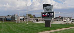
Norfolk has one college, Northeast Community College. Over 7,000 students take classes for credit there. Many others take non-credit courses. These include classes for the GED test. They also offer English as a second language and help for the Naturalization test.
The Norfolk Public School District has over 4,000 students. It has seven elementary schools, one junior high school, and two high schools. The high schools are Norfolk Senior High School and Alternatives For Success.
There are also several private schools. Norfolk Catholic Schools has a grade school and Norfolk Catholic High School. Two Lutheran elementary schools and a high school also serve students. St. Paul's Lutheran School is a Pre-K-8 school.
Media in Norfolk
The Norfolk Daily News is the city's main newspaper. It is published six days a week.
Norfolk has two television stations: KXNE-TV 19 and KNEN-LD 35. KXNE-TV is part of the NET Television network. KNEN-LD is part of the News Channel Nebraska (NCN) network.
The city also has several radio stations. These include WJAG 780 AM (news/talk) and several FM stations. The FM stations play different types of music. These include public radio, Christian talk, country, rock, and adult contemporary.
Transportation
Bus service to Norfolk is provided by Express Arrow.
The city also has a commercial airport, Norfolk Regional Airport.
Notable People from Norfolk
Many interesting people have connections to Norfolk:
- Jim Buchanan: A baseball pitcher for the St. Louis Browns.
- Max Carl: A singer and songwriter for the band .38 Special. He grew up nearby and graduated from a Norfolk High School.
- Orville Carlisle: He invented model rocketry in 1954.
- Johnny Carson: The famous television host moved to Norfolk at age 8. He graduated from Norfolk High School.
- Jeromey Clary: An offensive tackle for the San Diego Chargers. He was born in Norfolk.
- Mike Flood: A U.S. representative for Nebraska.
- Joyce Hall: She started the Norfolk Post Card Company in 1908. This company later became Hallmark Cards.
- Bill Lafleur: A punter for the San Francisco 49ers. He graduated from Norfolk Catholic High School.
- Scott Munter: A pitcher for the San Francisco Giants. He was born in Norfolk.
- Shane Osborn: A pilot known for the Hainan Island incident. He later became Nebraska's State Treasurer. He grew up in Norfolk.
- Thurl Ravenscroft: Best known as the voice of "Tony the Tiger." He also sang "You're a Mean One, Mr. Grinch." He was born in Norfolk.
- Don Stewart: An actor known for his role in Guiding Light.
- Dean White: A billionaire entrepreneur.
See also
 In Spanish: Norfolk (Nebraska) para niños
 | Claudette Colvin |
 | Myrlie Evers-Williams |
 | Alberta Odell Jones |


