Meridian Highway Bridge facts for kids
Quick facts for kids Meridian Highway Bridge |
|
|---|---|

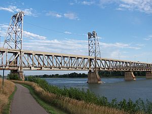
Meridian Bridge as seen from Yankton trail.
|
|
| Carries | pedestrians, previously 2 lanes of |
| Crosses | Missouri River |
| Locale | Yankton, South Dakota and Cedar County, Nebraska |
| Official name | Meridian Highway Bridge |
| Maintained by | City of Yankton, South Dakota |
| Characteristics | |
| Design | Vertical lift bridge double deck, Pratt through truss |
| Total length | 3,013 feet |
| Width | 33 feet |
| Longest span | 1,668 feet |
| Clearance below | feet |
| History | |
| Opened | 1924 |
|
Meridian Bridge
|
|
| Nearest city | South Yankton, Nebraska |
| Area | 2.4 acres (0.97 ha) |
| Architectural style | Prat vertical-lift truss |
| MPS | Highway Bridges in Nebraska MPS |
| NRHP reference No. | 93000537 |
| Added to NRHP | June 17, 1993 |
The Meridian Highway Bridge is a special bridge that used to carry U.S. Route 81 cars across the Missouri River. It connects Yankton, South Dakota with Cedar County, Nebraska. This bridge is a double-deck bridge. This means it has two levels, one on top of the other. Cars going into South Dakota used the top level. Cars going into Nebraska used the bottom level. Today, it's a popular path for people walking and biking.
Building the Meridian Bridge
The Meridian Bridge crosses the Missouri River. It connects Yankton, South Dakota in the north to Cedar County, Nebraska in the south. Before the bridge was built, people crossed the river in different ways.
One way was a ferry service, which started in 1870. A ferry is a boat that carries people and vehicles across water. Another way was a seasonal pontoon bridge. This bridge was made of floating sections. It was first used in 1890. Workers had to take the pontoon bridge apart and rebuild it twice a year. They would float it on open water in warmer months. Then, they would place it on solid ice in winter.
People wanted a permanent bridge. An effort to build one in 1915 stopped because of World War I. A new plan began in 1919. The Yankton Chamber of Commerce helped raise money. There were some money problems in 1922, which caused a short delay. But the new bridge was finished in the summer of 1924. It had a special moving part to let boats pass underneath.
How the Bridge Changed Over Time
The Meridian Bridge officially opened on October 11, 1924. It was a toll bridge, meaning drivers had to pay to cross it. This bridge was the last part of the Meridian Highway to be completed. This highway later became U.S. Route 81.
The bridge was designed to have trains on the lower level and cars on the upper level. It was a vertical-lift bridge. This type of bridge can lift its middle section up. This allowed tall boats to pass safely on the river below. However, trains never actually used the lower level of the bridge.
In 1953, the tolls were removed, so it became free to cross. The two levels were changed to carry one-way traffic. Cars going north used the top level. Cars going south used the bottom level.
Later, in the 1980s, the lifting parts were removed. The decorative railings on the top level were replaced with concrete barriers. In 1993, the bridge was added to the National Register of Historic Places. This means it is recognized as an important historical site.
On May 9, 2008, a weight limit was put on the bridge. This happened after inspectors found some rust on parts of the bridge. A new bridge, the Discovery Bridge, opened on October 11, 2008. This was exactly 84 years after the Meridian Bridge first opened. The Discovery Bridge replaced the Meridian Bridge for car traffic.
The Meridian Bridge was even used in a movie! A scene for the 2016 film Until Forever was filmed there.
What the Bridge is Used for Now
After the Discovery Bridge was finished, the Meridian Bridge got a new purpose. It was turned into a path for people walking and biking. It reopened in November 2011 for non-motorized traffic only. This means no cars or trucks are allowed.
A special two-block-long area for pedestrians was also added. The bridge crosses the Missouri National Recreational River. This area is part of the National Park Service. It is protected under the Wild and Scenic Rivers Act.
 | Charles R. Drew |
 | Benjamin Banneker |
 | Jane C. Wright |
 | Roger Arliner Young |


