Platte County, Nebraska facts for kids
Quick facts for kids
Platte County
|
|
|---|---|
| County of Platte | |

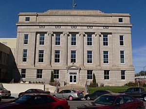
Platte County Courthouse
|
|

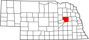
Location within the U.S. state of Nebraska
|
|
| Country | |
| State | |
| Established | January 26, 1856 |
| Named for | Platte River |
| County seat | Columbus |
| Largest city | Columbus |
| Area | |
| • Total | 685 sq mi (1,770 km2) |
| • Land | 674 sq mi (1,750 km2) |
| • Water | 11 sq mi (30 km2) 1.5% |
| Highest elevation | 1,657 ft (505 m) |
| Lowest elevation | 1,112 ft (339 m) |
| Population
(2020)
|
34,296 |
| • Density | 50.9/sq mi (19.7/km2) |
| Time zone | UTC−6 (Central) |
| • Summer (DST) | UTC−5 (CDT) |
| Area code | 402/531 |
| FIPS code | 31141 |
| GNIS feature ID | 835892 |
| Website | www.plattecounty.net |
Platte County is a county in the state of Nebraska, United States. In 2020, about 34,296 people lived there. The main city and county seat is Columbus. The county was officially created in 1855.
Platte County is part of the Columbus, NE Micropolitan Statistical Area. This means it's an important area for jobs and living, centered around Columbus. If you see a Nebraska license plate with the number 10, it means the car is from Platte County. This is because it had the 10th highest number of registered vehicles in 1922.
Contents
History of Platte County
Platte County was officially started in 1856. The first meeting of its governing group, the board of commissioners, happened the next year. This board helps make decisions for the county.
Geography and Rivers
The Platte River flows along the southern edge of Platte County. The Loup River also flows through the lower part of the county. It joins the Platte River near Columbus. The land in Platte County has gentle, rolling hills. Most of the land is used for farming.
The county covers about 685 square miles (1,774 square kilometers). Most of this area, about 674 square miles (1,746 square kilometers), is land. The remaining 11 square miles (28 square kilometers) are water.
Main Roads in Platte County
 U.S. Highway 30
 U.S. Highway 81
 Nebraska Highway 22
 Nebraska Highway 39
 Nebraska Highway 45
 Nebraska Highway 91
Public Transportation
- Express Arrow
Neighboring Counties
- Colfax County – to the east
- Butler County – to the southeast
- Polk County – to the south
- Merrick County – to the south
- Nance County – to the southwest
- Boone County – to the west
- Madison County – to the north
- Stanton County – to the northeast
Protected Natural Areas
- George Syas State Wildlife Management Area
Population Changes
| Historical population | |||
|---|---|---|---|
| Census | Pop. | %± | |
| 1860 | 782 | — | |
| 1870 | 1,899 | 142.8% | |
| 1880 | 9,511 | 400.8% | |
| 1890 | 15,437 | 62.3% | |
| 1900 | 17,747 | 15.0% | |
| 1910 | 19,006 | 7.1% | |
| 1920 | 19,464 | 2.4% | |
| 1930 | 21,181 | 8.8% | |
| 1940 | 20,191 | −4.7% | |
| 1950 | 19,910 | −1.4% | |
| 1960 | 23,992 | 20.5% | |
| 1970 | 26,508 | 10.5% | |
| 1980 | 28,852 | 8.8% | |
| 1990 | 29,820 | 3.4% | |
| 2000 | 31,662 | 6.2% | |
| 2010 | 32,236 | 1.8% | |
| 2020 | 34,296 | 6.4% | |
| US Decennial Census 1790-1960 1900-1990 1990-2000 2010 |
|||
The population of Platte County has grown a lot since 1860. In 2000, there were 31,662 people living in the county. About 29% of the people were under 18 years old. The average age was 36 years.
Towns and Villages
Platte County has several cities, villages, and other communities.
Cities in Platte County
- Columbus (This is the county seat, where the main government offices are.)
- Humphrey
- Newman Grove (part of this city is in Platte County)
Villages in Platte County
Special Designated Place
- Lakeview (This is a place defined by the census for statistics.)
Other Small Communities
County Townships
- Bismark
- Burrows
- Butler
- Columbus
- Creston
- Grand Prairie
- Granville
- Humphrey
- Joliet
- Lost Creek
- Loup
- Monroe
- Oconee
- St. Bernard
- Shell Creek
- Sherman
- Walker
- Woodville
Famous People from Platte County
- James Keogh was an important person in journalism and politics. He was an executive editor for Time magazine. He also led the speechwriting team for President Richard M. Nixon at the White House.
See also
 In Spanish: Condado de Platte (Nebraska) para niños
 | Victor J. Glover |
 | Yvonne Cagle |
 | Jeanette Epps |
 | Bernard A. Harris Jr. |

