Polk County, Nebraska facts for kids
Quick facts for kids
Polk County
|
|
|---|---|
| County of Polk | |

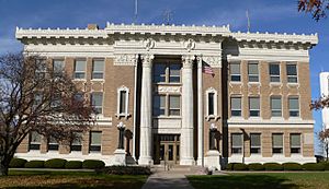
Polk County Courthouse in Osceola
|
|

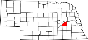
Location within the U.S. state of Nebraska
|
|
| Country | |
| State | |
| Established | January 26, 1856 |
| Organized | August 6, 1870 |
| Named for | James K. Polk |
| County seat | Osceola |
| Largest city | Stromsburg |
| Area | |
| • Total | 441 sq mi (1,140 km2) |
| • Land | 438 sq mi (1,130 km2) |
| • Water | 2.3 sq mi (6 km2) 0.5% |
| Highest elevation | 1,739 ft (530 m) |
| Lowest elevation | 1,089 ft (332 m) |
| Population | |
| • Total | 5,214 |
| • Estimate
(2021)
|
5,174 |
| Time zone | UTC−6 (Central) |
| • Summer (DST) | UTC−5 (CDT) |
| Area code | 402/531 |
| FIPS code | 31143 |
| GNIS feature ID | 835893 |
| Website | www.polkcounty.ne.gov |
Polk County is a county located in the state of Nebraska in the United States. In 2020, about 5,214 people lived here. The main town and county seat is Osceola.
Polk County was created in 1856 and officially started working as a county in 1870. It was named after James K. Polk, who was a President of the United States. If you see a Nebraska license plate with the number 41, it means the car is from Polk County. This number was given because Polk County had the 41st largest number of registered vehicles in 1922.
Contents
Exploring Polk County's Geography
Polk County is a place with rolling hills. The Platte River flows along its northwest side. Most of the land in the county is used for farming.
The U.S. Census Bureau says that Polk County covers a total area of 441 square miles. Out of this, 438 square miles is land, and only 2.3 square miles is water.
Main Roads in Polk County
You can travel through Polk County using these important roads:
 U.S. Highway 81
 Nebraska Highway 39
 Nebraska Highway 66
 Nebraska Highway 69
 Nebraska Highway 92
Neighboring Counties
Polk County shares its borders with several other counties:
- Butler County to the east
- Seward County to the southeast
- York County to the south
- Hamilton County to the southwest
- Merrick County to the west
- Platte County to the north
Polk County's Population Over Time
| Historical population | |||
|---|---|---|---|
| Census | Pop. | %± | |
| 1860 | 19 | — | |
| 1870 | 136 | 615.8% | |
| 1880 | 6,846 | 4,933.8% | |
| 1890 | 10,817 | 58.0% | |
| 1900 | 10,542 | −2.5% | |
| 1910 | 10,521 | −0.2% | |
| 1920 | 10,714 | 1.8% | |
| 1930 | 10,092 | −5.8% | |
| 1940 | 8,748 | −13.3% | |
| 1950 | 8,044 | −8.0% | |
| 1960 | 7,210 | −10.4% | |
| 1970 | 6,468 | −10.3% | |
| 1980 | 6,320 | −2.3% | |
| 1990 | 5,668 | −10.3% | |
| 2000 | 5,639 | −0.5% | |
| 2010 | 5,406 | −4.1% | |
| 2020 | 5,214 | −3.6% | |
| 2021 (est.) | 5,174 | −4.3% | |
| US Decennial Census 1790-1960 1900-1990 1990-2000 2010-2013 |
|||
In 2000, there were 5,639 people living in Polk County. Most people living there were White (98.92%). A small number of people were from other racial backgrounds.
About 29.90% of the homes had children under 18 living in them. The average family had about three people. The median age of people in the county was 42 years old.
Towns and Villages in Polk County
Polk County has a few cities and villages, along with some smaller, unincorporated communities.
Cities
- Osceola (This is the main town, also called the county seat)
- Stromsburg
Villages
Unincorporated Communities
These are smaller places that are not officially organized as cities or villages:
Townships
Polk County is also divided into smaller areas called townships:
- Canada
- Clear Creek
- Hackberry
- Island
- Osceola
- Platte
- Pleasant Home
- Stromsburg
- Valley
See also
 In Spanish: Condado de Polk (Nebraska) para niños
 | Calvin Brent |
 | Walter T. Bailey |
 | Martha Cassell Thompson |
 | Alberta Jeannette Cassell |

