Seward County, Nebraska facts for kids
Quick facts for kids
Seward County
|
|
|---|---|
| County of Seward | |

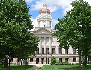
Seward County Courthouse in Seward
|
|

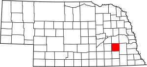
Location within the U.S. state of Nebraska
|
|
| Country | |
| State | |
| Established | March 16, 1855 |
| Organized | October 1865 |
| Named for | William H. Seward |
| County seat | Seward |
| Largest city | Seward |
| Area | |
| • Total | 576 sq mi (1,490 km2) |
| • Land | 571 sq mi (1,480 km2) |
| • Water | 4.5 sq mi (12 km2) 0.8% |
| Highest elevation | 1,598 ft (487 m) |
| Lowest elevation | 938 ft (286 m) |
| Population | |
| • Total | 17,609 |
| • Density | 30.571/sq mi (11.804/km2) |
| Time zone | UTC−6 (Central) |
| • Summer (DST) | UTC−5 (CDT) |
| Area code | 402/531 |
| FIPS code | 31159 |
| GNIS feature ID | 835901 |
| Website | countyofsewardne.com |
Seward County is a county in the state of Nebraska, United States. In 2020, about 17,609 people lived there. Its main town and county seat is Seward.
The county was formed in 1855. It was officially organized in 1867. It was first called Greene County. In 1862, it was renamed for William H. Seward. He was the Secretary of State for Presidents Abraham Lincoln and Andrew Johnson. Seward County is part of the Lincoln, NE Metropolitan Statistical Area. This means it is connected to the larger city of Lincoln.
In Nebraska, license plates have a special system. Seward County is shown by the number 16. This is because it had the sixteenth-largest number of vehicles registered when the system started in 1922.
Contents
Geography
Seward County has gently rolling hills. Much of the land is used for farming. Farmers often use center pivot irrigation to water their crops. The Big Blue River flows through the middle of the county, heading south.
The county covers a total area of 576 square miles. About 571 square miles of this is land. The remaining 4.5 square miles (0.8%) is water.
Protected Areas
Seward County is home to several protected natural areas. These places help protect wildlife and their habitats.
- Bur Oak State Wildlife Management Area
- Freeman Lakes Waterfowl Production Area
- North Lake Basin State Wildlife Management Area
- Oak Glen State Wildlife Management Area
- Tamora Waterfowl Production Area
Population Information
The population of Seward County has changed over many years. Here is a look at how many people have lived there during different times:
| Historical population | |||
|---|---|---|---|
| Census | Pop. | %± | |
| 1870 | 2,953 | — | |
| 1880 | 11,147 | 277.5% | |
| 1890 | 16,140 | 44.8% | |
| 1900 | 15,690 | −2.8% | |
| 1910 | 15,895 | 1.3% | |
| 1920 | 15,867 | −0.2% | |
| 1930 | 15,938 | 0.4% | |
| 1940 | 14,167 | −11.1% | |
| 1950 | 13,155 | −7.1% | |
| 1960 | 13,581 | 3.2% | |
| 1970 | 14,460 | 6.5% | |
| 1980 | 15,789 | 9.2% | |
| 1990 | 15,450 | −2.1% | |
| 2000 | 16,496 | 6.8% | |
| 2010 | 16,750 | 1.5% | |
| 2020 | 17,609 | 5.1% | |
| 2023 (est.) | 17,671 | 5.5% | |
| US Decennial Census 1790-1960 1900-1990 1990-2000 2010 |
|||
As of the year 2000, there were 16,496 people living in the county. There were about 6,013 households. A household is a group of people living together in one home. The average number of people in each household was about 2.53.
The population included people of different ages. About 24.7% of the people were under 18 years old. About 14.3% were between 18 and 24 years old. About 15.2% were 65 years old or older. The average age in the county was 36 years.
Communities
Seward County has several cities, villages, and other communities.
Cities
Villages
Census-designated Place
Unincorporated Communities
These are small communities that are not officially organized as cities or villages.
Ghost Town
- Pittsburg (A ghost town is a place where people used to live, but now it is mostly empty.)
Adjacent Counties
Seward County shares its borders with several other counties:
- Butler County – to the north
- Lancaster County – to the east
- Saline County – to the south
- Fillmore County – to the southwest
- York County – to the west
- Polk County – to the northwest
See also
 In Spanish: Condado de Seward (Nebraska) para niños
 | Victor J. Glover |
 | Yvonne Cagle |
 | Jeanette Epps |
 | Bernard A. Harris Jr. |

