Fillmore County, Nebraska facts for kids
Quick facts for kids
Fillmore County
|
|
|---|---|
| County of Fillmore | |

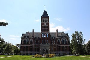
Fillmore County Courthouse in Geneva
|
|

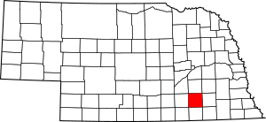
Location within the U.S. state of Nebraska
|
|
| Country | |
| State | |
| Established | January 26, 1856 |
| Organized | May 27, 1871 |
| Named for | Millard Fillmore |
| County seat | Geneva |
| Largest city | Geneva |
| Area | |
| • Total | 577 sq mi (1,490 km2) |
| • Land | 575 sq mi (1,490 km2) |
| • Water | 1.2 sq mi (3 km2) 0.2% |
| Highest elevation | 1,555 ft (474 m) |
| Lowest elevation | 1,171 ft (357 m) |
| Population
(2020)
|
5,551 |
| • Density | 9.7/sq mi (3.7/km2) |
| Time zone | UTC−6 (Central) |
| • Summer (DST) | UTC−5 (CDT) |
| Area code | 402/531 |
| FIPS code | 31059 |
| GNIS feature ID | 835851 |
| Website | www.fillmorecounty.org |
Fillmore County is a county in the state of Nebraska, USA. In 2020, about 5,551 people lived here. The main town, or county seat, is Geneva. The county is named after Millard Fillmore, who was the thirteenth President of the United States.
When Nebraska started using numbers on its license plates in 1922, Fillmore County was given the number 34. This was because it had the 34th largest number of vehicles registered in the county at that time.
Contents
History of Fillmore County
How Fillmore County Started
Fillmore County was created by the Nebraska Territorial Legislature in 1856. Its borders were set, and it was named after Millard Fillmore. He had finished being president in 1853.
The first homesteaders came to the county in 1866. Homesteaders were people who moved to new land to farm it. William O. Bussard and William C. Whitaker were among the first. They settled near the West Fork of the Big Blue River.
Early Settlements and Railroads
Not many people settled in the area until 1870. Most early settlers lived in the northern part of the county. This was partly because the Burlington and Missouri River Railroad was planned to run just north of Fillmore County.
In 1870, the first town, Fillmore City, was started. It was about four miles (6 km) north of where Grafton is today. The county's first post office opened there in 1871.
In 1871, the Burlington and Missouri Railroad changed its plans. They decided to build their tracks about five miles (8 km) further south. This new path was flatter, which made building the tracks cheaper. It also brought the railroad into northern Fillmore County.
Organizing the County
Fillmore County was officially organized in 1871. Before this, it was managed and taxed by Saline County, its neighbor to the east.
In April 1871, people voted to choose officers to organize the county. They also decided to put the county seat in the middle of the county. A town was planned and named "Henry." But it was on land owned by the state for schools, so it couldn't be settled right away. The state government had to pass a law to allow the land to be sold.
In 1872, the state passed the law. Around that time, the new county seat's name was changed from "Henry" to "Geneva." A local settler's daughter suggested the name, wanting it to be like her family's old home in Geneva, Illinois.
Growth and Challenges
The county grew quickly in the early 1870s. Three new towns were built along the Burlington railroad line: Exeter, Fairmont, and Grafton. The railroad named its towns in alphabetical order. By 1873, the county was "thickly settled."
However, growth slowed down in the mid-1870s. This was due to a worldwide economic problem called the Panic of 1873. Also, many grasshoppers invaded the area in the summer of 1874, which hurt farming.
More Railroads and Towns
As more railroad lines were built, new towns appeared. Around 1886, the Burlington railroad built another line. It ran east to west through southern Fillmore County. Towns like Shickley, Strang, and Ohiowa were founded along this route.
Another line connected Strang to Fairmont. Milligan was started in 1887 on the Kansas City and Omaha line.
Different Cultures Settle Here
Many different groups of European immigrants settled in Fillmore County.
- Many Czech families settled in eastern Fillmore County, including Milligan.
- Swedish immigrants settled in southwestern Fillmore County, near Shickley and Ong.
- German families formed communities in both the southeastern and southwestern parts of the county.
Geography of Fillmore County
Fillmore County covers about 577 square miles (1,490 km2). Most of this is land (575 square miles (1,490 km2)), and a small part is water (1.2 square miles (3.1 km2)).
Rivers and Water
The county is part of the Big Blue River area. Water in the county flows into the Big Blue River through its West Fork. It also flows through Turkey Creek and the Little Blue River.
Land Features
Fillmore County is in the eastern part of Nebraska's loess plain. This is a flat area made of soil carried by the wind long ago. The Big Blue River and its smaller streams have cut channels into this plain.
Many parts of the county have shallow dips in the land. These dips are lined with fine soil and can fill with rain or melted snow, creating temporary wetlands. These wetlands can be small or quite large.
Neighboring Counties
Fillmore County shares borders with these counties:
- York County – to the north
- Seward County – to the northeast
- Saline County – to the east
- Jefferson County – to the southeast
- Thayer County – to the south
- Nuckolls County – to the southwest
- Clay County – to the west
- Hamilton County – to the northwest
Protected Natural Areas
Fillmore County has several protected areas for wildlife:
- Bluebill State Wildlife Management Area
- Marsh Hawk State Wildlife Management Area
- Morphy Lagoon National Wildlife Management Area
- Rauscher Lagoon National Wildlife Management Area
- Redhead Wildlife Management Area
- Rolland Lagoon National Wildlife Management Area
- Sandpiper State Wildlife Management Area
- Sora Wildlife Management Area
Population of Fillmore County
| Historical population | |||
|---|---|---|---|
| Census | Pop. | %± | |
| 1870 | 238 | — | |
| 1880 | 10,204 | 4,187.4% | |
| 1890 | 16,022 | 57.0% | |
| 1900 | 15,087 | −5.8% | |
| 1910 | 14,674 | −2.7% | |
| 1920 | 13,671 | −6.8% | |
| 1930 | 12,971 | −5.1% | |
| 1940 | 11,417 | −12.0% | |
| 1950 | 9,610 | −15.8% | |
| 1960 | 9,425 | −1.9% | |
| 1970 | 8,137 | −13.7% | |
| 1980 | 7,920 | −2.7% | |
| 1990 | 7,103 | −10.3% | |
| 2000 | 6,634 | −6.6% | |
| 2010 | 5,890 | −11.2% | |
| 2020 | 5,551 | −5.8% | |
| US Decennial Census 1790-1960 1900-1990 1990-2000 2010 |
|||
In 2000, there were 6,634 people living in Fillmore County. About 97.75% of the people were White. Other groups included Black or African American, Native American, Asian, and Pacific Islander. About 1.66% of the population was Hispanic or Latino.
Many people in the county have German (48.6%), Czech (10.4%), Irish (7.1%), and English (7.0%) backgrounds.
The average age in the county was 41 years old. About 26.30% of the population was under 18.
Transportation in Fillmore County
Several important roads and a railway line pass through Fillmore County:
- U.S. Route 81 runs north and south through the county.
- U.S. Route 6 runs east and west across the northern part.
- Nebraska Highway 41 runs east and west through the middle.
- Nebraska Highway 74 runs east and west through the southern part.
- The BNSF Railway also runs east and west across northern Fillmore County, passing through Exeter, Fairmont, and Grafton.
Towns and Villages
City
- Geneva (This is the county seat, the main town where the county government is located.)
Villages
Unincorporated Communities
These are smaller communities that are not officially organized as cities or villages:
Ghost Towns
These are places where towns once existed but are now abandoned:
- Dudley
- Sawyer
- Buxton
- Turkey Creek
- Martland
- Lyman
- Fillmore
- Bryant
- Eden
Townships
Townships are smaller areas within a county, often used for local government or land division:
- Belle Prairie
- Bennett
- Bryant
- Chelsea
- Exeter-Fairmont
- Franklin
- Geneva
- Glengary
- Grafton
- Hamilton
- Liberty
- Madison
- Momence
- Stanton
- West Blue
See also
 In Spanish: Condado de Fillmore (Nebraska) para niños
 | Leon Lynch |
 | Milton P. Webster |
 | Ferdinand Smith |

